
Jackson County is a county located in the northeastern part of the U.S. state of Georgia. As of the 2010 census, the population was 60,485. The county seat is Jefferson.

Florence is a city in, and the county seat of, Lauderdale County, Alabama, United States, in the state's northwest corner.

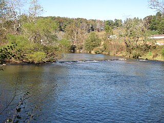
Elizabethton is a city in, and the county seat of Carter County, Tennessee, United States. Elizabethton is the historical site of the first independent American government located west of both the Eastern Continental Divide and the original Thirteen Colonies.

The Chattahoochee River forms the southern half of the Alabama and Georgia border, as well as a portion of the Florida - Georgia border. It is a tributary of the Apalachicola River, a relatively short river formed by the confluence of the Chattahoochee and Flint rivers and emptying from Florida into Apalachicola Bay in the Gulf of Mexico. The Chattahoochee River is about 430 miles (690 km) long. The Chattahoochee, Flint, and Apalachicola rivers together make up the Apalachicola–Chattahoochee–Flint River Basin. The Chattahoochee makes up the largest part of the ACF's drainage basin.

The Lane Cove River, a northern tributary of the Parramatta River, is a tide-dominated, drowned valley estuary west of Sydney Harbour, located in Sydney, New South Wales, Australia. The river is a tributary of the Parramatta River, winding through a bushland valley. It joins Parramatta River at Greenwich and Woolwich, where together they form an arm of Sydney Harbour.
New River State Park is a North Carolina state park in Ashe County, North Carolina in the United States. Located near Jefferson, North Carolina, it covers 2,911 acres (11.78 km2) in the protected New River watershed. The New River is one of the oldest rivers in the United States. It is considered by some geologists to be possibly one of the oldest rivers in the world, between 10 million and 360 million years old. New River State Park is open for year-round recreation, including canoeing, hiking, picnicking, fishing, camping and environmental education. The park is just off U.S. Route 221 in northwestern North Carolina.

Raven Rock State Park is a North Carolina state park in Harnett County, North Carolina in the United States. Located near Lillington, North Carolina, it covers 4,694 acres (19.00 km2) along the banks of the Cape Fear River. Raven Rock State Park is located on the eastern edge of the Piedmont.

The Ocmulgee River (ok-MUHL-gee) is a western tributary of the Altamaha River, approximately 255 mi (410 km) long, in the U.S. state of Georgia. It is the westernmost major tributary of the Altamaha.

The Chattahoochee-Oconee National Forest in northern Georgia comprises two United States National Forests, the Oconee National Forest in eastern Georgia and the Chattahoochee National Forest located in the North Georgia Mountains. The Chattahoochee National Forest is composed of an eastern and western forest. The western forest contains Johns Mountain, Little Sand Mountain, and Taylor Ridge. The combined total area of the Chattahoochee-Oconee National Forest is 866,468 acres (3,506 km2), of which the Chattahoochee National Forest comprises 750,145 acres (3,036 km2) and the Oconee National Forest comprises 116,232 acres (470 km2). The county with the largest portion of the eastern forest is Rabun County, Georgia, which has 148,684 acres (601.7 km2) within its boundaries.
Chattahoochee River National Recreation Area (CRNRA) preserves a series of sites between Atlanta and Lake Sidney Lanier along the Chattahoochee River, Georgia, U.S. The 48-mile (77 km) stretch of the river affords public recreation opportunities and access to historic sites. The National Recreation Area, a National Park Service unit, was established on August 15, 1978, by President Jimmy Carter.

Lake Sinclair is a man-made lake in central Georgia near Milledgeville. It is operated by Georgia Power.

Whipple Dam State Park is a Pennsylvania state park on 256 acres (104 ha) in Jackson Township, Huntingdon County, Pennsylvania in the United States. Whipple Lake is a man-made lake on 22 acres (8.9 ha) that was originally built during the height of the lumber era that swept through Pennsylvania in the late 19th and early 20th century to supply power for a sawmill. Whipple Dam State Park is 12 miles (19 km) south of State College, just east of Pennsylvania Route 26.

Milton State Park is an 82 acres (33 ha) Pennsylvania state park in Milton in Northumberland County, Pennsylvania in the United States. The park is on Montgomery Island in the West Branch Susquehanna River, just east of the village of West Milton in Union County. Milton State Park is on Pennsylvania Route 642.

The Palmetto Trail is a planned 425-mile-long (684 km) foot and mountain bike trail in South Carolina for recreational hiking and biking. Several of the sections are also equestrian trails. It will extend from the Oconee County mountains to the Intracoastal Waterway in Charleston County. It currently consists of 23 segments totaling 235 miles (378 km). Maps and trail guides are available.
Scull Shoals is a ghost town in northwestern Greene County, Georgia, United States.
Mayo River State Park is a North Carolina state park in Rockingham County, North Carolina in the United States. It is near Mayodan, North Carolina and covers 2,187-acre (8.85 km2) along the Mayo River. The park is one of the newest in the North Carolina system, having been authorized by the General Assembly in May 2003. An interim facility, called the Mayo Mountain Access, was opened to the public on April 1, 2010.
Kern River County Park is a large recreation facility located just north of Bakersfield, California. The facility is 1,012 acres (4.10 km2), and includes a park, zoo, golf course, and other amenities. The complex is served by Alfred Harrell Highway. The segment to the west of the park was built as a 4-lane local freeway. The segment to the east of the park was built as a 2-lane expressway, with land reserved for a future 4-lane freeway.

Carvers Creek State Park is a North Carolina state park in Cumberland County, North Carolina in the United States. Located north of Fayetteville, it covers 4,332 acres (17.53 km2) in the Sandhills region of the state. The park covers lands around Carvers Creek, a tributary of the Cape Fear River, and it borders Fort Bragg. The park is currently divided into two areas, Long Valley Farm and the Sandhills Property. The park is still being planned, and the state is planning to acquire more land for the park.

State Route 82 (SR 82) is a 36.2-mile-long (58.3 km) arc-shaped state highway in the northwest part of the U.S. state of Georgia. The highway travels from Winder to a point east of Gainesville.

Sisters State Park is a state park located at the southeast side of the town of Sisters in Deschutes County, Oregon, United States. The park property is bisected by U.S. Route 20 and Oregon Route 126, creating three separate parcels. The park covers 28 acres (11 ha) of undeveloped forest land along Whychus Creek. It is adjacent to two developed city parks that were once part of the state park. Sisters State Park is administered by the Oregon Parks and Recreation Department.


