Praia da Vitória is a municipality in the Portuguese archipelago of the Azores. With a population of 21,035, the second largest administrative authority on the island of Terceira, it covers an area of 161.27 square kilometres (62.27 sq mi), that extends from the northern coast halfway into the interior.

Santo Amaro, also known as Santo Amaro da Purificação, is a municipality in the state of Bahia in Brazil. The population is 60,131 in an area of 492.9 square kilometres (190.3 sq mi). It is located in the metropolitan area of Salvador. Santo Amaro is located approximately 73 kilometres (45 mi) from the city of Salvador. Santo Amaro was home to numerous Amerindian peoples until the arrival of the Portuguese, who developed the region for sugarcane production. Santo Amaro is now noted for its numerous historic structures. The city is also a center of Candomblé, having more than 60 terreiros, or temples of the religion.

Vila de São Sebastião, commonly shortened to São Sebastião, is a civil parish in the municipality of Angra do Heroísmo, on the island of Terceira in the Portuguese archipelago of the Azores. The population in 2011 was 2,096, in an area of 23.93 square kilometres (9.24 sq mi). It is in the southeastern part of the island of Terceira. It contains the localities Arrabalde, Boavista, Cavalas, Canada da Salga, Contendas, Cruz, Maria Vieira, Ribeira Seca de Cima, Ribeira Seca de Baixo, Salgueiros and Vila de São Sebastião.

Vila Franca do Campo is a town and municipality in the southern part of the island of São Miguel in the Portuguese Autonomous Region of the Azores. The population of the municipality was 11,229 in 2011, in an area of 77.97 km². The town proper, which incorporates the urbanized parishes São Miguel and São Pedro, has 4100 inhabitants.

São Cristóvão is a Brazilian municipality in the Northeastern state of Sergipe. Founded at the mouth of the Vaza-Barris River on January 1, 1590, the municipality is the fourth oldest settlement in Brazil. São Cristóvão is noted for its historic city square, São Francisco Square, and numerous early colonial-period buildings. The 3 hectares site was designated a UNESCO World Heritage Site in 2010.

Penafiel ([pɨnɐfiˈɛl]or is a municipality and former bishopric in the northern Portuguese district of Porto. Capital of the Tâmega Subregion, the population was 72,265 in 2011, in an area of 212.24 square kilometres.

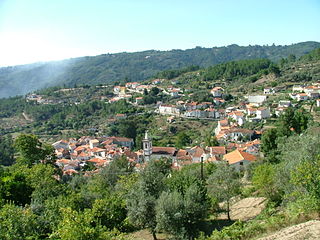
São Gião is a parish, in the North of Portugal, on Serra da Estrela, the highest mountain range in Portugal. It belongs to the municipality of Oliveira do Hospital, and the district (distrito) of Coimbra. The population in 2011 was 425, in an area of 14.55 km².

Miranda do Corvo is a town and a municipality in the Portuguese district of Coimbra, with an area of 126.38 square kilometres (48.80 sq mi) and 2011 population of 13,098 inhabitants.

The Visigoths entered Hispania in 415 and they rose to be the dominant people there until the Umayyad conquest of Hispania of 711 brought their kingdom to an end.

The Church of Cedofeita is a medieval church in the civil parish of Cedofeita, municipality of Porto, in the northern Grande Porto Subregion of Portugal. The Church is a rare architectural example of a single-nave vaulted-ceiling temple, and the only one in the traditional Entre-Douro-e-Minho Province region of Portugal. It is classified as a National Monument.
Arcozelo is a freguesia in the municipality (concelho) of Vila Nova de Gaia. The population in 2011 was 14,352, in an area of 8.50 km².

The Monastery of Rates was a Benedictine monastery located in the parish of Rates in the municipality of Póvoa de Varzim, in Portugal. The part of the monastery that has survived to this day is the bell-tower and, most importantly, the Church dedicated to St Peter of Rates, mostly known as Romanesque Church of Rates, which is a national monument since 1910. Reconstruction of the church began at the turn of the 11th to the 12th century, turning it into one of the oldest extant Romanesque churches in Portugal.

Jaguaripe is a municipality in the state of Bahia in the North-East region of Brazil. It covers 863.424 km2 (333.370 sq mi), and has a population of 18,981 with a population density of 18.32 inhabitants per square kilometer. Jaguaripe is located 130 km (81 mi) from the state capital of Bahia, Salvador. Jaguaripe shares a border with the municipalities of Aratuípe, Nazaré, Maragogipe, Laje, São Miguel das Matas, and Santo Antônio de Jesus. It was the first municipality created outside of Salvador, dating to 1693.

Nazaré, also known as Nazaré das Farinhas, is a municipality in the state of Bahia in the North-East region of Brazil. The municipality has a population of 28,594 with a population density of 107 inhabitants per square kilometer. It is located 110 km (68 mi) from the state capital of Bahia, Salvador. Nazaré is within the Bahian Recôncavo, an interior region of the state of Bahia. It borders the municipalities of Muniz Ferreira, Aratuípe, Jaguaripe, São Felipe, and Maragogipe. The Jaguaripe River crosses through the middle of the town. It is sits on the intersection of two Bahian state highways, BA-001 and BA-046.

The Church of Saint John the Baptist is a 15th-century Catholic church in Tomar, Portugal that was built by King Manuel I and is of Manueline architecture. As its name implies, the church is dedicated to Saint John the Baptist. It has been classified as a National Monument since 1910.

Igreja de Nossa Senhora da Nazaré is a colonial church in Luanda, Angola, built in 1664. It is located in the centre of the city, overlooking Luanda Bay.

A Church of São João Evangelista, or Carmelite Church of Aveiro, is an 18th-century church in the Praça Marquês de Pombal, in the civil parish of Glória e Vera Cruz, in the Portuguese municipality of Aveiro. It was declared a national monument in 1910.
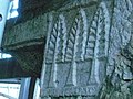
A Church of São Gião is an 18th-century church in the civil parish of São Gião, in the municipality of Oliveira do Hospital, in the Portuguese district of Coimbra. Classified as a national monument since 1910, it is locally known as the Cathedral das Beiras, although unrecognized by IGESPAR or the Diocese of Guarda.

The Church of Our Lady of Nazareth of Engenho Itaperoá is an abandoned 18th-century Roman Catholic church in São Cristóvão, Sergipe, Brazil. It is also referred to as the Chapel of Our Lady of Nazareth of Engenho Itaperoá. The church is located on the former Fazenda Itaperoá, a sugarcane plantation, west of the city center São Cristóvão. The church belonged to the Parish of Our Lady of Victory, which included Santo Antônio and São Gonçalo, in Camassari. It was listed as a historic structure by the State of Sergipe in 1984; despite its heritage designation, the church is in advanced state of ruin.