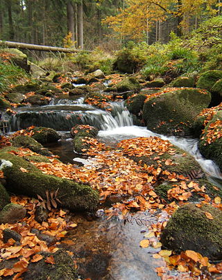
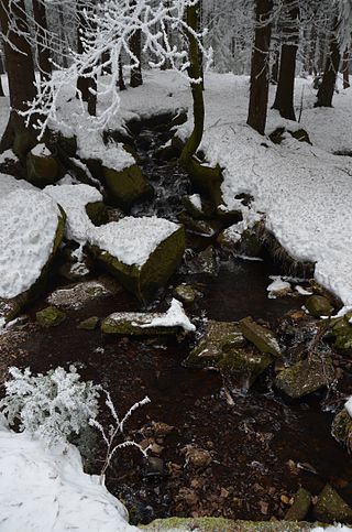
It rises at about 900 metres (3,000ft) above sea level on the northern slopes of the Brocken. During its first few kilometres it flows as a narrow brook, almost invisible to the observer, down the side of the Brocken. Known here as the Verdeckte Ilse ("hidden Ilse") it gurgles its way under blocks of granite that hide the stream bed from above.
The Ilse then rushes through the narrow Ilse valley, hemmed in to the east by the rugged, cross-topped Ilsestein, passes by Ilsenburg into the Harz Foreland, flows through Veckenstedt, Wasserleben, Osterwieck and Hornburg and discharges into the Oker near Börßum together with the Schiffgraben from the Großes Bruch. Its total length is around 40 kilometres (25mi).
Local folklore personifies the river as the beautiful Princess Ilse, who has her home in the rocks of the Ilsestein. The Ilse is mentioned in literary works such as the Die Harzreise by Heinrich Heine.
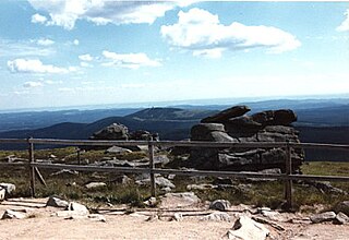
The Harz is a highland area in northern Germany. It has the highest elevations for that region, and its rugged terrain extends across parts of Lower Saxony, Saxony-Anhalt, and Thuringia. The name Harz derives from the Middle High German word Hardt or Hart. The name Hercynia derives from a Celtic name and could refer to other mountain forests, but has also been applied to the geology of the Harz. The Brocken is the highest summit in the Harz with an elevation of 1,141.1 metres (3,744 ft) above sea level. The Wurmberg is the highest peak located entirely within the state of Lower Saxony.
Harz National Park is a nature reserve in the German federal states of Lower Saxony and Saxony-Anhalt. It comprises portions of the western Harz mountain range, extending from Herzberg and Bad Lauterberg at the southern edge to Bad Harzburg and Ilsenburg on the northern slopes. 95% of the area is covered with forests, mainly with spruce and beech woods, including several bogs, granite rocks and creeks. The park is part of the Natura 2000 network of the European Union.
The Mulde is a river in Saxony and Saxony-Anhalt, Germany. It is a left tributary of the Elbe and is 124 kilometres (77 mi) long.
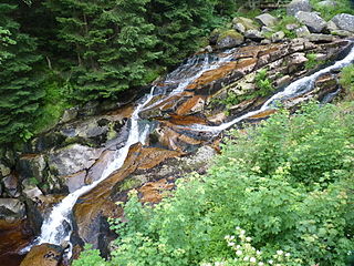
The Bode is a river in the German state of Saxony-Anhalt, a left tributary of the Saale. It rises in the Harz mountains and drains them in a northerly direction. After 169 kilometres (105 mi) it discharges into the Saale at Nienburg. The river is named after a legendary giant, the wild, rampaging, Bohemian, Prince Bodo, who, according to the Rosstrappe legend changed into a marauding dog that guarded the crown of Princess Brunhilde in the Kronensumpf in the present-day Bode Gorge. The gorge is the narrow section of the Bode valley between Treseburg and Thale.
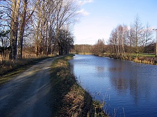
The Ohre is a river in northern Germany, left tributary to the Elbe. Its total length is 103 kilometres (64 mi). Its source is north of Wolfsburg, in Lower Saxony. It flows generally south-east, at first following the border of Lower Saxony and Saxony-Anhalt. After Buchhorst it flows completely through Saxony-Anhalt, along the Mittellandkanal. It flows into the Elbe in Rogätz, north of Magdeburg. The towns Brome, Calvörde, Haldensleben and Wolmirstedt lie along the river. The upper course of the Ohre is in the Drömling nature reserve.
Ilsenburg is a town in the district of Harz, in Saxony-Anhalt in Germany. It is situated under the north foot of the Harz Mountains, at the entrance to the Ilse valley with its little river, the Ilse, a tributary of the Oker, about six 6 miles (9.7 km) north-west of the town of Wernigerode. It received town privileges in 1959. Owing to its surrounding of forests and mountains as well as its position on the edge of the Harz National Park, Ilsenburg is a popular tourist resort. Since 2002, it is officially an air spa.
The river Jeetzel, which begins in the Altmark under the name Jeetze, flows from Saxony-Anhalt through Lower Saxony, in Germany. From its source near the village of Dönitz, it flows north through Beetzendorf, Salzwedel, Wustrow, Lüchow and Dannenberg, before joining the Elbe in Hitzacker. Its total length is 73 kilometres (45 mi).
The Holtemme is a 47-kilometre (29 mi) long tributary of the river Bode in Saxony-Anhalt, Germany.
The Hohnekamm or Hohne Kamm is a mountain ridge up to 900 m above sea level high in the Harz mountains of central Germany. It is located in the state of Saxony-Anhalt, and is well known for its rock towers or tors, the Hohneklippen.
The Kalte Bode is the left-hand headstream of the Bode in the High Harz Mountains in the German state of Saxony-Anhalt. It is 17 kilometres (11 mi) long.
The Warme Bode is the right-hand headstream of the Bode in the High Harz mountains of central Germany in the states of Lower Saxony and Saxony-Anhalt. It is 23 kilometres (14 mi) long and is formed by the confluence of the Große Bode and Kleine Bode rivers.
The Rappbode is a right-hand, southwestern tributary of the River Bode in the Harz mountains in the German state of Saxony-Anhalt. In its lower reaches it is impounded by the Rappbode Dam, the largest dam in the Harz.
The Renneckenberg is a mountain, roughly 933 metres (3,061 ft) high, in the High Harz part of the Harz mountain range of central Germany within the borough of Wernigerode in the state of Saxony-Anhalt.
The Wormke is a river of Saxony-Anhalt, Germany, in the Harz Mountains. It is a left tributary of the Kalte Bode, about 6.7 kilometres (4.2 mi) long.
The Ecker is a 28-kilometre (17 mi), right-hand, southeast tributary of the Oker which runs mainly through the Harz mountains in the German states of Saxony-Anhalt and Lower Saxony.
Harz granite is found in the Harz Mountains of central Germany. It may be divided into five types, all of which were widely used as natural stone: Knaupsholz granite, Birkenkopf granite, Wurmberg granite, Königskopf granite and Ilsestein granite. The first three granites were widely used in North Germany, Belgium and the Netherlands and, later, also in East Germany. Knaupsholz granite was "for a long time one of the most important types of cut stone in the former GDR".
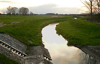
Großer Graben and Schiffgraben together are an artificial waterbody with ambiguous flows in Lower Saxony and Saxony-Anhalt, Germany, partly forming the border of both Länder.
The Bremen Hut in the Harz Mountains is a refuge hut and shelter in that part of the Harz National Park lying within the borough of Ilsenburg (Harz) in Harz district in the German state of Saxony-Anhalt.
The Ilsestein is a prominent granite rock formation near the town of Ilsenburg in the Harz mountains of central Germany. Offering a scenic view over the Ilse valley to the Brocken massif, the highest mountain of the range, it is today a popular tourist destination.
The Scharfenstein is a mountain, 697.6 m above sea level (NN) high, in the Harz Mountains of Germany, near Ilsenburg in the district of Harz in Saxony-Anhalt. It is part of the Harz National Park.
This page is based on this Wikipedia article Text is available under the CC BY-SA 4.0 license; additional terms may apply. Images, videos and audio are available under their respective licenses.