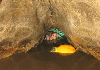
Ingleborough Cave (formerly known as Clapham Caves) is a show cave close to the village of Clapham in North Yorkshire, England, adjacent to where the water from Gaping Gill resurges.
That part of the cave that is open to the public follows a fossil gallery for some 500 metres (1,640ft). The passage is spacious, and well decorated with stalagmitic formations.
Beyond the show cave, the fossil gallery continues until it meets the main stream. The water can be followed upstream through passages under Trow Gill, to where it emerges from a sump at Terminal Lake which has been connected by divers to Gaping Gill, and followed downstream into Lake Pluto which has been connected by divers to Beck Head Stream Cave.
A connection has also been made with Fox Holes, a cave near Trow Gill.
A small stream in the show cave drops into a rift called the Abyss. An underwater connection has been made between the passage at the bottom and Beck Head Cave, the resurgence for the Gaping Gill water.
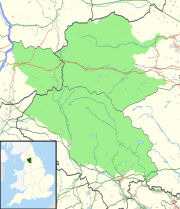
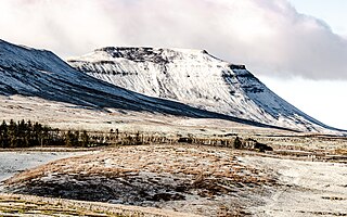
Ingleborough is the second-highest mountain in the Yorkshire Dales, England. It is one of the Yorkshire Three Peaks, and is frequently climbed as part of the Three Peaks walk. A large part of Ingleborough is designated as a Site of Special Scientific Interest and National Nature Reserve and is the home of a new joint project, Wild Ingleborough, with aims to improve the landscape for wildlife and people.
Gaping Gill is a natural cave in North Yorkshire, England. It is one of the unmistakable landmarks on the southern slopes of Ingleborough – a 98-metre (322 ft) deep pothole with the stream Fell Beck flowing into it. After falling through one of the largest known underground chambers in Britain, the water disappears into the bouldery floor and eventually resurges adjacent to Ingleborough Cave.
Clapham is a village in the civil parish of Clapham cum Newby in the Craven district of North Yorkshire, England. It was previously in the West Riding of Yorkshire. It lies within the Yorkshire Dales National Park, 6 miles (10 km) north-west of Settle, and just off the A65 road.
The Ease Gill Cave System is the longest, and most complex cave system in Britain as of 2011, with around 41 miles (66 km) of passages, including connections only passable by cave diving. It spans the valley between Leck Fell and Casterton Fell. The water resurges into Leck Beck.
The Marble Arch Caves are a series of natural limestone caves located near the village of Florencecourt in County Fermanagh, Northern Ireland. The caves are named after the nearby Marble Arch, a natural limestone arch at the upstream end of Cladagh Glen under which the Cladagh River flows. The caves are formed from three rivers draining off the northern slopes of Cuilcagh mountain, which combine underground to form the Cladagh. On the surface, the river emerges from the largest karst resurgence in Ireland, and one of the largest in the United Kingdom. At 11.5 kilometres (7.1 mi) the Marble Arch Caves form the longest known cave system in Northern Ireland, and the karst is considered to be among the finest in the British Isles.
Great Douk Cave is a shallow cave system lying beneath the limestone bench of Ingleborough in Chapel-le-Dale, North Yorkshire, England. It is popular with beginners and escorted groups, as it offers straightforward caving, and it is possible to follow the cave from where a stream emerges at a small waterfall to a second entrance close to where it sinks 600 yards (549 m) further up the hill. It lies within the Ingleborough Site of Special Scientific Interest.
A gill or ghyll is a ravine or narrow valley in the North of England and parts of Scotland. The word originates from the Old Norse gil. Examples include Dufton Ghyll Wood, Dungeon Ghyll, Troller's Gill and Trow Ghyll. As a related usage, Gaping Gill is the name of a cave, not the associated stream, and Cowgill, Masongill and Halton Gill are derived names of villages.
John Birkbeck was a Yorkshireman, banker, alpinist, and pioneer potholer.
Fell Beck is a stream near the foot of Ingleborough, in the Yorkshire Dales National Park. It is notable for running into Gaping Gill, the second-largest natural cave shaft in the UK. As it falls down the shaft for 110 metres it is the tallest unbroken waterfall in the UK. At times it is blocked off by a temporary dam to allow members of the public to descend the Gaping Gill shaft on a winch.
The Nidderdale Caves are a series of caves in Upper Nidderdale in North Yorkshire, England. There are two cave systems and most of the caves are in some way linked with one or the other. The smaller system is the Eglin cave system in the valley of How Stean Beck, a tributary of the River Nidd, associated with How Stean Gorge. The larger system is the Goyden cave system under the valley of the River Nidd, which flows east from Scar House Reservoir, then south, and shortly after disappears underground down several sinkholes to reappear at the rising just beyond the village of Lofthouse. Cavers can access several sections of this system via the different entrances.
Bar Pot is one of the entrances to the Gaping Gill cave system being located about 340 metres (370 yd) south of Gaping Gill Main Shaft, on Ingleborough in the Yorkshire Dales. It is a popular entrance into the system, being one of the easiest, driest, and having just two vertical pitches to contend with. It lies within the designated Ingleborough Site of Special Scientific Interest.
Disappointment Pot is one of the entrances to the Gaping Gill cave system, located in a steep grassy shakehole some 120 metres (130 yd) south-east of Gaping Gill Main Shaft. Its mainly narrow stream passage descends a number of small shafts to enter the main system as a major inlet of Hensler's Master Cave. It lies within the designated Ingleborough Site of Special Scientific Interest.
Stream Passage Pot is one of the entrances to the Gaping Gill system being located about 320 metres (350 yd) ESE of Gaping Gill Main Shaft. It is a popular and sporting entrance into the system, featuring three well-watered big shafts. It is the highest entrance of the Gaping Gill system, so the full depth of the system, 198 metres (650 ft), is measured from its entrance. It lies within the designated Ingleborough Site of Special Scientific Interest.
Flood Entrance Pot is one of the entrances to the Gaping Gill cave system located about 300 metres (330 yd) south of Gaping Gill Main Shaft. It was the first alternative entrance into the main system to be explored, and it is now a popular entrance into the system, with a fine 38-metre (125 ft) pitch landing in Gaping Gill's South-East Passage. It lies within the designated Ingleborough Site of Special Scientific Interest.
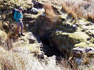
Rat Hole is one of the entrances to the Gaping Gill cave system, located in the north bank of Fell Beck 30 metres (33 yd) upstream of Gaping Gill Main Shaft. A small, awkward, tube-like passage descends into a stream passage, and hence to a 100-metre (330 ft) shaft into Gaping Gill Main Chamber. The sharp and loose nature of the rock, and the quantity of water prevented full exploration for over 80 years, but the current route is described in one guide book as "a technical and exhilarating adventure". It lies within the designated Ingleborough Site of Special Scientific Interest.
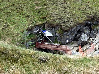
Jib Tunnel, also known as Lateral Passage is one of the entrances into the Gaping Gill cave system, located behind a large boulder in the north bank of Fell Beck adjacent to Gaping Gill Main Shaft. Although short, it leads to Lateral Shaft, a direct descent into Gaping Gill Main Chamber which is a popular caving route, and has had considerable significance in the history of the exploration of Gaping Gill. It lies within the designated Ingleborough Site of Special Scientific Interest.
Weathercote Cave is a natural solutional cave in Chapel-le-Dale, North Yorkshire, England. It has been renowned as a natural curiosity since the eighteenth century, and was accessible to paying visitors until 1971. The entrance is a large shaft about 20 metres (66 ft) deep, dominated by a waterfall entering at one end. It lies within the designated Ingleborough Site of Special Scientific Interest.
The Three Counties System is a set of inter-connected limestone solutional cave systems spanning the borders of Cumbria, Lancashire and North Yorkshire in the north of England. The possibility of connecting a number of discrete cave systems in the area to create a single super-system that spans the county borders was first proposed by Dave Brook in 1968, and it was achieved in 2011. The system is currently over 86 kilometres (53 mi) long, making it the longest in the UK and the thirtieth longest in the world, and there continues to be scope for considerably extending the system.
The Long Kin East Cave - Rift Pot system is a limestone cave system on the southern flanks of Ingleborough, North Yorkshire in England lying within the designated Ingleborough Site of Special Scientific Interest. Long Kin East Cave starts as a long meandering stream passage but then plummets down a 58-metre (190 ft) deep shaft when it meets a shattered fault into which Rift Pot also descends. At the bottom, the stream flows through some low canals and sumps, to eventually emerge at Austwick Beck Head in Crummackdale.
This page is based on this Wikipedia article Text is available under the CC BY-SA 4.0 license; additional terms may apply. Images, videos and audio are available under their respective licenses.