Innerdalen

Last updated
Innerdalen nature reserve
IUCN category V (protected landscape/seascape)

Innerdalstarnet cows.jpg

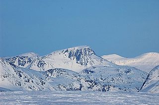
Innerdalstårnet seen from the valley floor
Location Sunndal Municipality, Møre og Romsdal, Norway
Nearest city Sunndalsøra
Coordinates 62°43′52″N08°44′43″E / 62.73111°N 8.74528°E / 62.73111; 8.74528 Coordinates: 62°43′52″N08°44′43″E / 62.73111°N 8.74528°E / 62.73111; 8.74528
Area 73 square kilometres (28 sq mi)
Established 1967
Governing body Norwegian Directorate for Nature Management

Innerdalen is a valley in Sunndal Municipality in Møre og Romsdal county, Norway. In 1967, the valley was established as Norway's first nature reserve. The valley and nature reserve begins at the village of Ålvundeid by the Norwegian National Road 70 in the west and stretches approximately 25 kilometres (16 mi) to the east to Innerdalsporten. It lies within the Trollheimen mountain range. [1]

Møre og Romsdal County (fylke) of Norway

Møre og RomsdalUrban East Norwegian: [²møːrə ɔ ˈrʊmsdɑːl](listen) is a county in the northernmost part of Western Norway. It borders the counties of Trøndelag, Oppland, and Sogn og Fjordane. The county administration is located in the town of Molde, while Ålesund is the largest town. The county is governed by the Møre og Romsdal County Municipality which includes an elected county council and a county mayor. The national government is represented by the county governor.

Norway constitutional monarchy in Northern Europe

Norway, officially the Kingdom of Norway, is a Nordic country in Northwestern Europe whose territory comprises the western and northernmost portion of the Scandinavian Peninsula; the remote island of Jan Mayen and the archipelago of Svalbard are also part of the Kingdom of Norway. The Antarctic Peter I Island and the sub-Antarctic Bouvet Island are dependent territories and thus not considered part of the kingdom. Norway also lays claim to a section of Antarctica known as Queen Maud Land.

Nature reserve protected area for flora, fauna or features of geological interest

A nature reserve is a protected area of importance for flora, fauna or features of geological or other special interest, which is reserved and managed for conservation and to provide special opportunities for study or research. Nature reserves may be designated by government institutions in some countries, or by private landowners, such as charities and research institutions, regardless of nationality. Nature reserves fall into different IUCN categories depending on the level of protection afforded by local laws. Normally it is more strictly protected than a nature park.

The valley is regularly visited by mountain climbers. Some of the mountains include Store Trolla (1,850 metres or 6,070 feet, highest in Trollheimen), Skarfjellet (1,790 metres or 5,870 feet), and Innerdalstårnet (1,452 metres or 4,764 feet). For glacier hiking, there is a glacier on top of Kongskrona called Vinnufonna.

Trollheimen mountain

Trollheimen is a mountain range in Møre og Romsdal and Trøndelag counties in central Norway. The mountain range is part of the Scandinavian Mountains.

Skarfjellet mountain in Norway

Skarfjellet is a 1,790-metre (5,870 ft) tall mountain in Sunndal Municipality in Møre og Romsdal county, Norway. It lies along the southern side of the Innerdalen valley, just west of the mountain Innerdalstårnet, and about 9 kilometres (5.6 mi) northeast of the village of Sunndalsøra. It is the northern peak along the Trolla ridge where the highest point is Store Trolla at 1,850 metres (6,070 ft). The mountain is a popular rock climbing destination.

Innerdalstårnet mountain in Norway

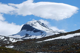
Innerdalstårnet or Dalatårnet is a 1,452-metre (4,764 ft) tall mountain on the south side of the Innerdalen valley in Sunndal Municipality in Møre og Romsdal county, Norway. It is located about 15 kilometres (9.3 mi) southeast of the village of Ålvundeid. The mountain is also known as the Matterhorn of Norway for its characteristic pyramidal shape.

In 2001, Norsk Tindeklub (Norwegian Mountaineering Association) released a mountain guide for Innerdalen (in Norwegian) and they also have a private cabin, Giklingdalshytta, beneath the mountain Innerdalstårnet. The Norwegian Mountain Touring Association has two cabins in the valley, Innerdalshytta (originally built 1889) and Renndølsetra.

Norsk Tindeklub

Norsk Tindeklub is a Norwegian mountaineering association. The club was founded in 1908. The association issues climbing guides and mountaineering books. The club has issued several jubilee books in the series Norsk Fjellsport. The club has three cabins, in Skagadalen (Hurrungane), Vengedalen (Romsdalen) and Flatvaddalen (Innerdalen).

Related Research Articles

Sunndal Municipality in Møre og Romsdal, Norway

Sunndal  is a municipality in the Nordmøre region located in the northeast part of Møre og Romsdal county, Norway. The administrative center of the municipality is the village of Sunndalsøra. Other villages include Gjøra, Grøa, Hoelsand, Jordalsgrenda, Romfo, Ålvund, Ålvundeidet, and Øksendalsøra. With an area of 1,712 square kilometres (661 sq mi), it is the largest municipality in Møre og Romsdal county. The important occupations in Sunndal include industry, public services, retail, and farming.

Surnadal Municipality in Møre og Romsdal, Norway

Surnadal  is a municipality in Møre og Romsdal county, Norway. It is part of the Nordmøre region. The administrative centre is the village of Skei. Other villages in Surnadal include Glærem, Mo, Stangvik, Surnadalsøra, Sylte, Todalsøra, and Åsskard.

Kebnekaise Swedens highest mountain

Kebnekaise is the highest mountain in Sweden. The Kebnekaise massif, which is part of the Scandinavian Mountains, has two main peaks, of which the southern, glaciated one is highest at 2,097.5 metres (6,882 ft) above sea level as of August 2014. The northern peak is 2,096.8 metres (6,879 ft) and free of ice. Kebnekaise lies in Swedish Lapland, about 150 kilometres (93 mi) north of the Arctic Circle and west of Kiruna near the Kungsleden hiking trail between Abisko and Hemavan.

Rondane National Park national park

Rondane National Park is the oldest national park in Norway, established on 21 December 1962. The park contains ten peaks above 2,000 metres (6,560 ft), with the highest being Rondeslottet at an altitude of 2,178 m (7,146 ft). The park is an important habitat for herds of wild reindeer.

Blåfjella–Skjækerfjella National Park national park in Trøndelag, Norway

Blåfjella–Skjækerfjella National Park lies in Trøndelag county, Norway. It is the third largest national park on the Norwegian mainland and one of the largest remaining true wilderness areas. It is located in the municipalities of Verdal, Snåsa, Grong, Lierne, and Steinkjer. The terrain is characterized by mountain plains, lakes, forested valleys, marshes, and a few mountain peaks. The Sami people have lived in and used the area for several centuries. There are many Sami cultural monuments here, such as settlements, gathering places, burial sites, and sacred places.

Jotunheimen National Park national park

JotunheimenNational Park is a national park in Norway, recognized as one of the country's premier hiking and fishing regions. The national park covers 1,151 km² and is part of the larger area Jotunheimen. More than 250 peaks rise above 1,900 metres, including Northern Europe's two highest peaks: Galdhøpiggen at 2,469 metres, and Glittertind at 2,465 metres.

Bymarka park area in Trondheim, Norway

Bymarka is a large park and nature reserve on the west side of the city of Trondheim in Trøndelag county, Norway.

Saltfjellet–Svartisen National Park national park in Nordland, Norway

Saltfjellet–Svartisen National Park is a national park in Nordland county in Norway. It is located within the municipalities of Beiarn, Meløy, Rana, Rødøy, Saltdal, and Bodø. European route E06 and the Nordland Line both follow the southern and eastern borders around the park. The park's eastern border is the Norway-Sweden border and a portion of this border is shared with the Vindelfjällen Nature Reserve which lies in Sweden.

Saltfjellet mountain range in Nordland, Norway

Saltfjellet is a mountain area in Nordland county, Norway that separates the two regions of Helgeland and Salten. It is also a cultural border between the Southern and Central parts of Sápmi.

Snota mountain in Norway

Snota is a prominent mountain in the Trollheimen mountain range in the municipality of Surnadal in Møre og Romsdal county, Norway. It is also the highest mountain in the municipality of Surnadal. It lies west of the mountain Trollhetta and north of the mountain Neådalssnota.

Gjevilvatnet lake in Oppdal, Norway

Gjevillvatnet is a lake in the municipality of Oppdal in Trøndelag county, Norway. It is located in the Trollheimen mountain range, about 5 kilometres (3.1 mi) south of the mountain Blåhøa and about 5 kilometres (3.1 mi) northwest of the village of Vognillan.

Speilsalen glacier in Oppdal, Norway

Speilsalen was a natural glacial formation caused by a river underneath a glacier in the Trollheimen mountains in the municipality of Oppdal in Trøndelag county, Norway. It was located at the northeast base of the mountain Blåhøa.

Trolla (mountain) mountain

Trolla is a mountain in the Trollheimen mountain range in Sunndal Municipality in Møre og Romsdal county, Norway. It is located about 10 kilometres (6.2 mi) east of the village of Sunndalsøra and about 3.5 kilometres (2.2 mi) north of the village of Grøa. The mountain is made up of several peaks along the ridge of the mountain:

Trollhetta mountain in Surnadal/Rindal, Norway

Trollhøtta or Trollhetta is a mountain on the border of Trøndelag and Møre og Romsdal counties in Norway. The 1,616-metre (5,302 ft) tall mountain is located on the border of the municipalities of Surnadal and Rindal. It is part of the Trollheimen mountain range, just east of the lake Gråsjøen and the mountains Snota and Neådalssnota. To the south, across the valley Svartådalen, you see the mountains Geithetta and Svarthetta.

Kongskrona mountain in Norway

Kongskrona is a 1,818-metre (5,965 ft) tall mountain peak in the municipality of Sunndal in Møre og Romsdal county, Norway. It is the higher of the two peaks on the main mountain Vinnufjellet. Its neighbouring peak is Dronningkrona, which is about 2 metres shorter. The name means King's crown in Norwegian.

Såtbakkollen mountain in Norway

Såtbakkollen is a 1,632-metre (5,354 ft) tall mountain in Sunndal Municipality in Møre og Romsdal county, Norway. It is located in the Trollheimen mountain range, just north of the Sunndalen valley. It forms the southern end of the "Tårn massif", which also includes Tåga, Tårnfjellet, and the quite famous Innerdalstårnet. Other mountains nearby include Navardalsnebba, Trolla, and Skarfjellet.

Sylan mountain range in Norway and Sweden

Sylan (Norwegian), Sylarna (Swedish), or Bealjehkh is a mountain range on the border between Norway and Sweden. The mountain range lies in Trøndelag and Jämtland counties.

Tverrådalskyrkja mountain in Norway

Tverrådalskyrkja is a mountain on the border between the municipalities of Luster and Skjåk, Norway. It is part of the Breheimen mountain range within Breheimen National Park, just north of the large Harbardsbreen glacier. It is 23 kilometres (14 mi) north of the village of Skjolden in Luster and 33 kilometres (21 mi) southwest of Bismo in Skjåk.

References

  1. Store norske leksikon. "Innerdalen" (in Norwegian). Retrieved 2010-12-05.