
Samnanger is a municipality in the Midhordland region of Hordaland county, Norway. The administrative centre of the municipality is the village of Tysse. Other main villages in the municipality include Haga and Bjørkheim in Nordbygda. The municipality is located about 20 kilometres (12 mi) east of the city of Bergen, Norway's second largest city. It surrounds the inner part of the Samnangerfjorden and the surrounding valleys. There are mountains that surround the municipality. The development of hydroelectric power plants started here in 1909.

Hornindalsvatnet is Norway's and Europe's deepest lake, officially measured to a depth of 514 metres (1,686 ft). Its surface is 53 metres (174 ft) above sea level, which means that its bottom is 461 metres (1,512 ft) below sea level.

Verdalsøra is a town in the municipality of Verdal in Trøndelag county, Norway. The town is the administrative center of the municipality. It is located along the Trondheimsfjord at the mouth of the river Verdalselva. The village of Vinne lies 4 kilometres (2.5 mi) to the southeast, Trones lies about 5 kilometres (3.1 mi) to the north, the villages of Forbregd/Lein lie about 4 kilometres (2.5 mi) to the northeast, and the village of Stiklestad lies about 3 kilometres (1.9 mi) to the east. In 1998, the municipal council of Verdal voted to grant the urban area of Verdalsøra town status under the laws of Norway.

Malm (help·info) is the administrative centre of the municipality of Verran in Trøndelag county, Norway. The village of Malm is located along the Breistadsundet strait which flows into the Trondheimsfjorden. The village of Bartnes lies across the strait from Malm. The village lies about a 32 kilometres (20 mi) drive northwest of the town of Steinkjer, about 12 kilometres (7.5 mi) northwest of the village of Follafoss, and about 20 kilometres (12 mi) south of the village of Namdalseid. The Norwegian County Road 720 runs through the village.

Vossevangen or Voss is the administrative centre of Voss municipality in Hordaland county, Norway.

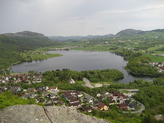
Nordfjordeid is the administrative centre of the municipality of Eid in Sogn og Fjordane county, western Norway. It is located at the end of the Eidsfjorden, an arm off of the main Nordfjorden, west of the large lake Hornindalsvatnet. The village of Stårheim is located about 12 kilometres (7.5 mi) to the west, the village of Mogrenda is about 5 kilometres (3.1 mi) to the east, and the village of Lote is about 7 kilometres (4.3 mi) to the southeast.

Baugevatnet is a lake that lies in Tysfjord Municipality in Nordland county, Norway. The 4.99-square-kilometre (1.93 sq mi) lake is located about 25 kilometres (16 mi) east of the village of Kjøpsvik and just 1.5 kilometres (0.93 mi) northwest of the border with Sweden. The lake Båvrojávrre lies about 3 kilometres (1.9 mi) to the southwest and the lake Langvatnet lies about the same distance to the north.
Langvatnet (Norwegian) or Tjoaddnejávrre (Lule Sami) is a lake that lies on the border between Norway and Sweden. Almost all of the lake is located in Tysfjord Municipality in Nordland county, Norway with a very small part of the lake in Jokkmokk Municipality in Norrbotten County, Sweden. The 5.46-square-kilometre (2.11 sq mi) lake is located about 20 kilometres (12 mi) southeast of the village of Kjøpsvik in Tysfjord.
Nilsebuvatnet is a lake in the municipalities of Forsand and Hjelmeland in Rogaland county, Norway. The 2.47-square-kilometre (0.95 sq mi) lake lies in the Lyseheiane mountains about 13 kilometres (8.1 mi) north of the village of Lysebotn and about 25 kilometres (16 mi) east of the village of Årdal. The lake is regulated by a small dam on the southwest corner of the lake. The dam provides water for the Lysebotn power station. The lake drains out into the river Storåna which flows westward towards Årdal. The lake is accessible by a small service road from Lysebotn which leads up to the dam.
Vostervatnet is a lake in the municipality of Strand in Rogaland county, Norway. The 2.62-square-kilometre (1.01 sq mi) lake lies in the northwestern part of Strand, just south of the Fognafjorden. The village of Tau lies about 3.5 kilometres (2.2 mi) southwest of the lake. The main outflow of the lake is the river Fiskåna, which flows north from the northeastern corner of the lake, down the hill to the village of Fiskå on the shore of the fjord.

Holmavatnet is a lake the Setesdalsheiene mountains of Southern Norway. It is located on the border of the municipalities of Suldal, Vinje, and a small part in Bykle. The southeastern corner of the lake is in Bykle, and it is the northernmost part of all of Aust-Agder county. The lake Skyvatn is located about 5 kilometres (3.1 mi) to the south of the lake.
Frøylandsvatnet is a lake in the municipality of Sandnes in Rogaland county, Norway. The 0.48-square-kilometre (120-acre) lake lies on the south side of the village of Hommersåk, about 10 kilometres (6.2 mi) northeast of the city of Sandnes. The lake empties into a small river that runs out of the north end of the lake. The river runs through Hommersåk into an arm of the Gandsfjorden.
Byavatnet is a lake in the municipality of Levanger in Trøndelag county, Norway. It is located about 2.5 kilometres (1.6 mi) south of the village of Ekne and about 3 kilometres (1.9 mi) west of the village of Ronglan. The lake Hammervatnet lies about 3.5 kilometres (2.2 mi) south of Byavatnet and the lake Sønningen lies about 1.5 kilometres (0.93 mi) to the northwest. The 2.31-square-kilometre (570-acre) lake is about 5 kilometres (3.1 mi) long and about 800 metres (0.5 mi) wide.
Gilten is a lake in the municipality of Steinkjer in Trøndelag county, Norway. The 31.62-square-kilometre (12.21 sq mi) lake lies in the northern part of Steinkjer, about 8 kilometres (5.0 mi) northeast of the village of Kvam, about 1.5 kilometres (0.93 mi) north of the village of Følling, and about 14 kilometres (8.7 mi) east of the village of Namdalseid. The lake is only accessible by road from Namdalseid, even though most of the 31.62-square-kilometre (12.21 sq mi) lake lies in Steinkjer. The lake Bangsjøan lies to the northeast and the lake Snåsavatnet lies to the south.

Gravatnet is a lake in the municipality of Sirdal in Vest-Agder county, Norway. The 5.33-square-kilometre (2.06 sq mi) lake is located about 9 kilometres (5.6 mi) north of the small village of Lunde. The lake lies immediately south of the lake Valevatn, which flows out into Gravatnet. The water in Gravatnet is stopped by a dam on the south side. The water is regulated at an elevation of 660 metres (2,170 ft) and it flows out through the small river Gravassåni which is a tributary of the big river Sira.
Hoklingen is a lake in the municipality of Levanger in Trøndelag county, Norway. The 6.1-square-kilometre (2.4 sq mi) lake lies just to the east of the village of Åsen and about 6 kilometres (3.7 mi) south of the village of Skogn.

Dingevatn or Dingevatnet is the 18th deepest lake in Norway, reaching a maximum depth of 220 metres (720 ft). It is located in the municipality of Gulen in Sogn og Fjordane county. The 2.84-square-kilometre (1.10 sq mi) lake is located just east of the village of Dingja, about 1 kilometre (0.62 mi) southeast of the mouth of the Sognefjorden. The lake lies about 4 kilometres (2.5 mi) north of the municipal center of Eivindvik. The lake flows out into the small Dingjaelva river, which runs past the village of Dingja before emptying into the Sognesjøen strait.

Čorotjávri is a lake in Karasjok Municipality in Finnmark county, Norway. The 4-square-kilometre (1.5 sq mi) lake lies on the Finnmarksvidda plateau about 15 kilometres (9.3 mi) north of the small village of Šuoššjávri, just east of the municipal boundary with Kautokeino Municipality.

Hommersåk is a village in Sandnes municipality in Rogaland county, Norway. The village is located in the borough of Riska in the northern part of the municipality. It is situated about 12 kilometres (7.5 mi) northeast of the city centre of Sandnes, along the shore of the Riskafjorden, an arm off the main Gandsfjorden. The 2.14-square-kilometre (530-acre) village has a population (2015) of 6,312; giving the village a population density of 2,950 inhabitants per square kilometre (7,600/sq mi).

Brekke is a village in the northeastern part of Gulen Municipality in Sogn og Fjordane county, Norway. The village of Brekke has a population (2001) of 299 people.

