Isola di Lolando

Last updated
Isola di Lolando
Isolda-di-lolando-site-photo-3.jpg
Pilings from the Lolando Island sea wall
USA Florida relief location map.jpg
Red pog.svg
Isola di Lolando
Isola di Lolando
North Atlantic Ocean laea relief location map.jpg
Red pog.svg
Isola di Lolando
Isola di Lolando (North Atlantic)
Geography
Location North Atlantic
Coordinates 25°48′15″N80°09′30″W / 25.8043°N 80.1584°W / 25.8043; -80.1584 Coordinates: 25°48′15″N80°09′30″W / 25.8043°N 80.1584°W / 25.8043; -80.1584
Administration
County Miami-Dade
Pilings from the Lolando Island sea wall, with Belle Isle, Rivo Alto Island, and Di Lido Island visible in the background. Isolda-di-lolando-site-photo-2.jpg
Pilings from the Lolando Island sea wall, with Belle Isle, Rivo Alto Island, and Di Lido Island visible in the background.

Isola di Lolando is an unfinished artificial island in Biscayne Bay, Florida. Hurricane damage and economic collapse caused the project to be abandoned shortly after the start of construction, but pilings remain visible in the bay and are a hazard to navigation.

Biscayne Bay lagoon located on the Atlantic coast of South Florida

Biscayne Bay is a lagoon that is approximately 35 miles (56 km) long and up to 8 miles (13 km) wide located on the Atlantic coast of South Florida, United States. It is usually divided for purposes of discussion and analysis into three parts: North Bay, Central Bay, and South Bay. Its area is 428 square miles (1,110 km2). The drainage basin covers 938 square miles (2,430 km2).

Florida State of the United States of America

Florida is the southernmost contiguous state in the United States. The state is bordered to the west by the Gulf of Mexico, to the northwest by Alabama, to the north by Georgia, to the east by the Atlantic Ocean, and to the south by the Straits of Florida. Florida is the 22nd-most extensive, the 3rd-most populous, and the 8th-most densely populated of the U.S. states. Jacksonville is the most populous municipality in the state and the largest city by area in the contiguous United States. The Miami metropolitan area is Florida's most populous urban area. Tallahassee is the state's capital.

History

In the early 1920s, audacious developers like John S. Collins were known for selling pre-construction property in the middle of Biscayne Bay before the islands had even been built. Demand was strong and there was virtually no environmental regulation, leading developers to envision filling Biscayne Bay with artificial islands. With unlimited waterfront property available, it seemed that the land boom had no end in sight.

John S. Collins Developer of Miami Beach, Florida

John Stiles Collins was an American Quaker farmer from Moorestown Township, New Jersey who moved to South Florida and attempted to grow vegetables and coconuts on the swampy, bug-infested stretch of land between Miami and the ocean, a barrier island which became Miami Beach.

The Shoreland Company and The Venetian Island Company were attempting to build a chain of new Venetian Islands in the water south of the Julia Tuttle Causeway in north Biscayne Bay. The first was to stretch from the causeway to Di Lido Island, and was to be called Isolda di Lolando, [1] continuing the Venetian theme of the existing successful artificial island projects.

Venetian Islands, Florida Neighborhood of Miami in Miami-Dade County, Florida, United States

The Venetian Islands are a chain of artificial islands in Biscayne Bay in the cities of Miami and Miami Beach, Florida. The islands are, from west to east: Biscayne Island (Miami), San Marco Island (Miami), San Marino Island, Di Lido Island, Rivo Alto Island, and Belle Isle. Flagler Monument Island remains an uninhabited picnic island, originally built in 1920 as a memorial to railroad pioneer Henry Flagler. The islands are connected by bridges from the Miami mainland to Miami Beach.

In 1925 the population explosion in South Florida had begun to strain local resources, and railway shipping companies began raising prices. In October the old Danish war ship Prinz Valdemar capsized in the channel in the port of Miami on its way to becoming a floating hotel, blocking shipping access to Miami for weeks. That summer brought the 1926 Miami Hurricane, which devastated an unprepared populace and heavily damaged local infrastructure. The Shoreland Company went bankrupt in 1927 amid objections to "further mutilation of the waterway". The 1929 stock market crash and subsequent onset of the Great Depression [2] ensured that Lolando Island was never completed.

Great Depression 20th-century worldwide economic depression

The Great Depression was a severe worldwide economic depression that took place mostly during the 1930s, beginning in the United States. The timing of the Great Depression varied across nations; in most countries it started in 1929 and lasted until the late-1930s. It was the longest, deepest, and most widespread depression of the 20th century. In the 21st century, the Great Depression is commonly used as an example of how intensely the world's economy can decline.

A Miami real estate bubble burst in the mid-1920s as a land boom fueled by outside speculators was stricken by economic realities and unexpected hurricanes. [3] One failed development project left its remains scarring north Biscayne Bay near Miami Beach, Florida. Concrete pilings from the sea wall of the incomplete Isola di Lolando still remain perfectly aligned in the shape of a new "Venetian island", stretching from the northern tip of Di Lido Island to the Julia Tuttle Causeway.

The Florida land boom of the 1920s was Florida's first real estate bubble, which burst in 1925. The land boom left behind entire new cities, such as Coral Gables, Hialeah, Miami Springs, Opa-locka, Miami Shores, and Hollywood. It also left behind the remains of failed development projects such as Aladdin City in south Miami-Dade County, Fulford-by-the-Sea in what is now North Miami Beach, Miami's Isola di Lolando in north Biscayne Bay, Boca Raton, as it had originally been planned, and Palm Beach Ocean just north of Palm Beach. The land boom shaped Florida's future for decades and created entire new cities out of the Everglades land that remain today. The story includes many parallels to the real estate boom of the 2000s, including the forces of outside speculators, easy credit access for buyers, and rapidly appreciating property values.

Miami Beach, Florida City in Florida, United States

Miami Beach is a coastal resort city in Miami-Dade County, Florida, United States. It was incorporated on March 26, 1915. The municipality is located on natural and man-made barrier islands between the Atlantic Ocean and Biscayne Bay, the latter of which separates the Beach from Miami. The neighborhood of South Beach, comprising the southernmost 2.5 square miles (6.5 km2) of Miami Beach, along with downtown Miami and the Port of Miami, collectively form the commercial center of South Florida. Miami Beach's estimated population is 92,307 according to the most recent United States census estimates. Miami Beach is the 26th largest city in Florida based on official 2017 estimates from the US Census Bureau. It has been one of America's pre-eminent beach resorts since the early 20th century.

The pilings sit in about 5–10 feet of water and extend about 5–10 feet above the water, depending on the tide. The pilings and the island's outline shape are clearly visible from the Julia Tuttle Causeway as well as from many of the tall buildings that overlook the bay. They present a clear hazard to boat navigation and the interior of the island is a peaceful place that remains free of boat and jet ski traffic for kayakers, dolphin, manatee, sting rays, manta rays, and many types of fish.

Though faint, the island's pilings and outline can still be seen from space, via Google Earth and Google Maps, [4] and from Yahoo Maps. [5]

Isola di Lolando piling ruins seen from Julia Tuttle Causeway Isola di lolando miami beach 01.jpg
Isola di Lolando piling ruins seen from Julia Tuttle Causeway

Related Research Articles

Key Biscayne, Florida Village in Florida, United States

Key Biscayne is an island town in Miami-Dade County, Florida, United States. The population was 12,344 at the 2010 census.

Artificial island An island constructed by people

An artificial island or man-made island is an island that has been constructed by people rather than formed by natural means. Artificial islands may vary in size from small islets reclaimed solely to support a single pillar of a building or structure, to those that support entire communities and cities. Early artificial islands included floating structures in still waters, or wooden or megalithic structures erected in shallow waters.

Key Biscayne island in the United States of America

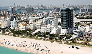
Key Biscayne is an island located in Miami-Dade County, Florida, United States, between the Atlantic Ocean and Biscayne Bay. It is the southernmost of the barrier islands along the Atlantic coast of Florida, and lies south of Miami Beach and southeast of Miami. The key is connected to Miami via the Rickenbacker Causeway, originally built in 1947.

Interstate 195 (Florida) Highway in Florida

Interstate 195 (I-195) is a 4.4-mile-long (7.1 km) spur freeway connecting I-95 in the west with Miami Beach in the east. It crosses Biscayne Bay by traveling over the Julia Tuttle Causeway, named after Miami founder Julia Tuttle.

Adrienne Arsht Center station Miami Metromover station

Adrienne Arsht Center station, formerly Omni station, is a Metromover station in the Arts & Entertainment District neighborhood of Downtown, Miami, Florida, United States. The station is adjacent to the Adrienne Arsht Center for the Performing Arts, just west of The Miami Herald building and the Venetian Causeway, and directly south of the MacArthur Causeway.

Venetian Causeway Bridge in Florida, United States of America

The Venetian Causeway crosses Biscayne Bay between Miami on the mainland and Miami Beach on a barrier island in south Florida. The man-made Venetian Islands and non-bridge portions of the causeway were created by materials which came from the dredging of the bay. The Venetian Causeway follows the original route of the Collins Bridge, a wooden 2.5 mi (4 km) long structure built in 1913 by John S. Collins and Carl G. Fisher which opened up the barrier island for unprecedented growth and development.

Julia Tuttle Founder of Miami City

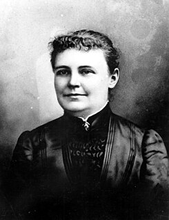
Julia DeForest Tuttle was an American businesswoman who was largely responsible for, and the original owner of, the land upon which Miami, Florida, was built. For this reason, she is called the "Mother of Miami." She is the only woman to found a major American city.

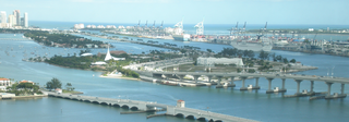
State Road 886, also known as Port Boulevard, is a causeway connecting the Port of Miami with downtown Miami, Florida. Its western terminus is an intersection with U.S. Route 1 just north of Bayside Marketplace, and its eastern terminus is at the Port of Miami entrance. It received its FDOT designation in 1980.

State Road 913 is an access road between the village of Key Biscayne on the island of Key Biscayne and I-95 in Miami on the western end of Biscayne Bay. The only part that is state maintained is South 26th Road ; Miami-Dade County maintains the Rickenbacker Causeway across the Biscayne Bay and Virginia Key to Key Biscayne. Inside the village of Key Biscayne, the roadway is known as Crandon Boulevard after it crosses Bear Cut. Mile markers are posted along the entire route, with zero at the entrance to Bill Baggs Cape Florida State Park at the south end of Crandon Boulevard.

State Road 922 is a 5.548 miles (8.929 km) east–west road built in 1951, passing through the cities of North Miami, Bay Harbor Islands, and Bal Harbour, Florida. Locally, the street is also known as North 125th Street, North Miami Boulevard, Northeast 123rd Street, Broad Causeway, 96th Street, and Kane Concourse. Its western terminus is an intersection with Northwest Seventh Avenue one block west of Interstate 95; its eastern terminus is an intersection with SR A1A. The street is an important commercial artery in northeastern Miami-Dade County, with stores lining much of the route, including the Bal Harbour Shops mall near its eastern terminus.

MacArthur Causeway Bridge in Florida, United States of America

The General Douglas MacArthur Causeway is a six-lane causeway which connects Downtown, Miami, Florida and South Beach, Miami Beach via Biscayne Bay.

Rickenbacker Causeway Bridge in Florida, United States of America

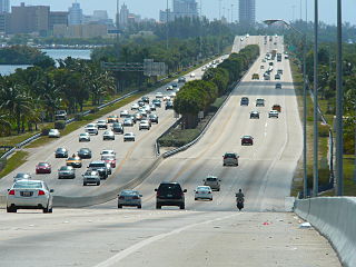
The Rickenbacker Causeway is a causeway which connects Miami, Florida, United States to the barrier islands of Virginia Key and Key Biscayne across Biscayne Bay.

Belle Isle (Miami Beach) Neighborhood of Miami Beach in Miami-Dade County, Florida, United States

Belle Isle is a neighborhood in the city of Miami Beach on an island in Biscayne Bay, Florida, United States. It is the easternmost of the Venetian Islands, a chain of artificial islands in Biscayne Bay in the cities of Miami and Miami Beach. It is home to apartment buildings, a portion of the Venetian Causeway, a city of Miami Beach park, and a hotel. It is between Rivo Alto Island and the main barrier island of Miami Beach.

Di Lido Island Neighborhood of Miami Beach in Miami-Dade County, Florida, United States

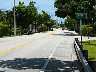
Di Lido Island is a neighborhood in the city of Miami Beach on a man-made island in Biscayne Bay, Florida, United States. It is the third island from the east of the Venetian Islands, a chain of artificial islands in Biscayne Bay in the cities of Miami and Miami Beach. It is between San Marino Island and Rivo Alto Island. It is home to residential neighborhoods and a portion of the Venetian Causeway. The unfinished artificial island Isola di Lolando from the Florida land boom of the 1920s is located near the north tip of Di Lido Island.

Flagler Monument Island Neighborhood of Miami Beach in Miami-Dade County, Florida, United States

Flagler Memorial Island is an uninhabited artificial island of South Beach in the city of Miami Beach in Biscayne Bay, Florida, United States. A 110-foot (34 m) high obelisk with allegorical sculptures at its base stands as a monument to Miami pioneer Henry M. Flagler, and was built in the center of the freshly constructed island in memory of Flagler, who died in 1913.

Rivo Alto Island is a neighborhood of in the city of Miami Beach on a man-made island in Biscayne Bay, Florida, United States. It is one of the Venetian Islands, a chain of artificial islands in Biscayne Bay in the cities of Miami and Miami Beach. It is between Di Lido Island and Belle Isle. It is home to residential neighborhoods and a portion of the Venetian Causeway.

San Marino Island Neighborhood of Miami Beach in Miami-Dade County, Florida, United States

San Marino Island is a neighborhood in the city of Miami Beach on a man-made island in Biscayne Bay, Florida, United States. It is one of the Venetian Islands, a chain of artificial islands in Biscayne Bay in the cities of Miami and Miami Beach. It is between San Marco Island and Di Lido Island. It is home to residential neighborhoods and a portion of the Venetian Causeway.

Central Business District (Miami)

Central Business District (CBD) is the historic city center of what has become Greater Downtown Miami, in Miami, Florida, United States. It is generally bound by Biscayne Boulevard, Bayfront Park and Museum Park on the east, the Miami River to the south, North 6th Street to the north, and Interstate 95 to the west. While it is technically Miami's official "downtown", the term "Downtown Miami" has come to refer to a much larger 3.8-square-mile (10 km2) area along the bay from the Rickenbacker Causeway to the Julia Tuttle Causeway. It is also distinct from the financial district, which in this case is neighboring Brickell to the south. However, the downtown core has over 5,000,000 square feet (460,000 m2) of office space, including more than fifteen buildings with greater than 100,000 sq ft (9,300 m2) of floor space.

References