Isunngua

Last updated

Isunngua (old spelling: Isúngua) is a highland in the Qeqqata municipality in central-western Greenland, located immediately west of the Greenland Ice Sheet edge. In large part it is covered by the tundra, although in the immediate vicinity of the Sermersuaq ice sheet it gradually becomes exposed, barren, and largely devoid of life. The climate is polar continental, with the area receiving very little rainfall. [1] Isunngua is a calving site for reindeer.

Qeqqata Municipality in Greenland, Kingdom of Denmark

Qeqqata is a municipality in western Greenland, operational from 1 January 2009. The municipality was named after its location in the central-western part of the country. Its population is 9,620 as of January 2013. The administrative center of the municipality is in Sisimiut. It consists of the previously unincorporated area of Kangerlussuaq, as well as two former municipalities of western Greenland:

Greenland autonomous country within the Kingdom of Denmark

Greenland is an autonomous constituent country of the Kingdom of Denmark between the Arctic and Atlantic oceans, east of the Canadian Arctic Archipelago. Though physiographically a part of the continent of North America, Greenland has been politically and culturally associated with Europe for more than a millennium. The majority of its residents are Inuit, whose ancestors began migrating from the Canadian mainland in the 13th century, gradually settling across the island.

Tundra biome where the tree growth is hindered by low temperatures and short growing seasons

In physical geography, tundra is a type of biome where the tree growth is hindered by low temperatures and short growing seasons. The term tundra comes through Russian тундра from the Kildin Sami word тӯндар meaning "uplands", "treeless mountain tract". Tundra vegetation is composed of dwarf shrubs, sedges and grasses, mosses, and lichens. Scattered trees grow in some tundra regions. The ecotone between the tundra and the forest is known as the tree line or timberline.

Contents

Geography

Isunnguata Sermia glacier forming the northern boundary of the Isunngua highlands Isunnguata-sermia-greenland.jpg
Isunnguata Sermia glacier forming the northern boundary of the Isunngua highlands
Meltwater canyon in Isunngua Isunngua-greenland.jpg
Meltwater canyon in Isunngua

Isunngua is notable for a gravel road which leads through it towards the edge of the Greenland Ice Sheet, located 40 km (25 mi) east of Kangerlussuaq, and due to trivial approach it remains a popular tourist target, [2] although very few hikers make the journey on foot, or explore the neighboring glaciers.

Gravel mix of crumbled stone (grain size range = 2-63 mm according to ISO 14688)

Gravel is a loose aggregation of rock fragments. Gravel is classified by particle size range and includes size classes from granule- to boulder-sized fragments. In the Udden-Wentworth scale gravel is categorized into granular gravel and pebble gravel. ISO 14688 grades gravels as fine, medium, and coarse with ranges 2 mm to 6.3 mm to 20 mm to 63 mm. One cubic metre of gravel typically weighs about 1,800 kg.

Kangerlussuaq Place in Greenland, Kingdom of Denmark

Kangerlussuaq, , is a settlement in western Greenland in the Qeqqata municipality located at the head of the fjord of the same name. It is Greenland's main air transport hub and the site of Greenland's largest commercial airport. The airport dates from American settlement during and after World War II, when the site was known as Bluie West-8 and then Sondrestrom Air Base. The Kangerlussuaq area is also home to Greenland's most diverse terrestrial fauna, including muskoxen, caribou, and gyrfalcons. The settlement's economy and population of 499 is almost entirely reliant on the airport and tourist industry.

The highland is bounded from the north by the Isunnguata Sermia glacier, [3] from the south by Russell Glacier and Aajuitsup Tasia lake, and from the west by Sanningasoq twin lake.

Glacier Persistent body of ice that is moving under its own weight

A glacier is a persistent body of dense ice that is constantly moving under its own weight; it forms where the accumulation of snow exceeds its ablation over many years, often centuries. Glaciers slowly deform and flow due to stresses induced by their weight, creating crevasses, seracs, and other distinguishing features. They also abrade rock and debris from their substrate to create landforms such as cirques and moraines. Glaciers form only on land and are distinct from the much thinner sea ice and lake ice that form on the surface of bodies of water.

Russell Glacier (Greenland) glacier in Greenland

Russell Glacier is a glacier in the Qeqqata municipality in central-western Greenland. It flows from the Greenland ice sheet in the western direction. The front of the glacier is located 25 km (16 mi) east of Kangerlussuaq. It is active, advancing 25 m (82 ft) every year, and due to easy approach it remains a popular tourist target.

Aajuitsup Tasia lake in Qeqqata, Greenland

Aajuitsup Tasia is a large lake in central-western Greenland, in the Qeqqata municipality. It is located approximately 12 km (7.5 mi) northeast of Kangerlussuaq. It is of elongated oval shape, with its western shore at 67°04′45″N50°30′02″W and its eastern shore at 67°05′35″N50°16′30″W. Aajuitsup Tasia is an oligotrophic lake of 32 m (105 ft) depth, covering an area of 1,350ha.

Both glaciers flow to the west from the ice sheet, which constrains Isunngua from the east. The average height of the highland hills is approximately 500–530 metres (1,640–1,740 ft). [3] The highland is dotted with freshwater lakes, kettles, and meltwater outflow lakes saturated with glacial silt.

Kettle (landform) A depression/hole in an outwash plain formed by retreating glaciers or draining floodwaters

A kettle is a depression/hole in an outwash plain formed by retreating glaciers or draining floodwaters. The kettles are formed as a result of blocks of dead ice left behind by retreating glaciers, which become surrounded by sediment deposited by meltwater streams as there is increased friction. The ice becomes buried in the sediment and when the ice melts, a depression is left called a kettle hole, creating a dimpled appearance on the outwash plain. Lakes often fill these kettles, these are called kettle hole lakes. Another source is the sudden drainage of an ice-dammed lake. When the block melts, the hole it leaves behind is a kettle. As the ice melts, ramparts can form around the edge of the kettle hole. The lakes that fill these holes are seldom more than 10 m (33 ft) deep and eventually become filled with sediment. In acid conditions, a kettle bog may form but in alkaline conditions, it will be kettle peatland.

Meltwater

Meltwater is water released by the melting of snow or ice, including glacial ice, tabular icebergs and ice shelves over oceans. Meltwater is often found in the ablation zone of glaciers, where the rate of snow cover is reducing. Meltwater can be produced during volcanic eruptions, in a similar way in which the more dangerous lahars form.

Turbidity The cloudiness of a fluid caused by large numbers of particles that are generally invisible to the naked eye

Turbidity is the cloudiness or haziness of a fluid caused by large numbers of individual particles that are generally invisible to the naked eye, similar to smoke in air. The measurement of turbidity is a key test of water quality.

Road to the ice sheet

In the spring of 2000 the Swedish construction group Skanska's Greenlandic subsidiary completed six months' work in establishing a 30 kilometres (19 mi) road for the testing company Nausta, which operates a testing site in northern Sweden. The road runs through the glacial valley of Akuliarusiarsuup Kuua, from Kangerlussuaq to the edge of the permanent inland ice in Isunngua. A road stretching 150 km (93 mi) was laid on the inland ice. Nausta built the facility to complement the winter testing done by Volkswagen in northern Sweden and Finland. [4]

Sweden constitutional monarchy in Northern Europe

Sweden, officially the Kingdom of Sweden, is a Scandinavian Nordic country in Northern Europe. It borders Norway to the west and north and Finland to the east, and is connected to Denmark in the southwest by a bridge-tunnel across the Öresund, a strait at the Swedish-Danish border. At 450,295 square kilometres (173,860 sq mi), Sweden is the largest country in Northern Europe, the third-largest country in the European Union and the fifth largest country in Europe by area. Sweden has a total population of 10.2 million of which 2.5 million has a foreign background. It has a low population density of 22 inhabitants per square kilometre (57/sq mi). The highest concentration is in the southern half of the country.

Skanska AB is a multinational construction and development company based in Sweden. Skanska is the fifth largest construction company in the world according to Construction Global magazine. Notable Skanska projects include the World Trade Center Transportation Hub project, 30 St Mary Axe, MetLife Stadium, Mater Dei Hospital, among others.

Akuliarusiarsuup Kuua river in Greenland

Akuliarusiarsuup Kuua is a river and valley of the same name in the Qeqqata municipality in central-western Greenland. Its source is the meltwater outflow from Russell Glacier, an outflow of the Greenland ice sheet. The river is a tributary of Qinnguata Kuussua, the main river in the Kangerlussuaq area. For most of its run, the river flows very slowly through the sandur basin of the valley, forming meanders amongst large fields of glacial silt quicksand. The climate is polar continental, with the area receiving very little rainfall.

The site at Kangerlussuaq was primarily used in the summer half of the year, from April through October. The entire testing ground was used to test cars' performance in extreme cold and conditions of near-zero friction. The cars were flown from Europe to Kangerlussuaq, and then driven to the proving grounds after last-minute checks. This project was abandoned and from 2006 the road leading to the edge of the ice cap is maintained for tourist purposes only, though access to the last segment of the road is limited and requires a key to open the padlocked gate. Ice activity has demolished the inland ice segment of the road, and it now ends in Isunngua, on the edge of the ice sheet.

Europe Continent in the Northern Hemisphere and mostly in the Eastern Hemisphere

Europe is a continent located entirely in the Northern Hemisphere and mostly in the Eastern Hemisphere. It is bordered by the Arctic Ocean to the north, the Atlantic Ocean to the west and the Mediterranean Sea to the south. It comprises the westernmost part of Eurasia.

Coordinates: 67°08′40″N50°10′00″W / 67.14444°N 50.16667°W / 67.14444; -50.16667

Photographs

Related Research Articles

A kame delta is a glacial landform formed by a stream of melt water flowing through or around a glacier and depositing material, known as kame deposits. Upon entering a proglacial lake at the end (terminus) of a glacier, the river/stream deposit these sediments. This landform can be observed after the glacier has melted and the delta's asymmetrical triangular shape is visible. Once the glacier melts, the edges of the delta may subside as ice under it melts. Glacial till is deposited on the lateral sides of the delta, as the glacier melts.

Greenland ice sheet glacier in Greenland

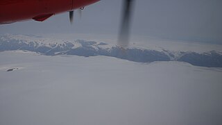
The Greenland ice sheet is a vast body of ice covering 1,710,000 square kilometres (660,000 sq mi), roughly 80% of the surface of Greenland.

Glacial motion

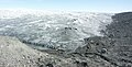
Glacial motion is the motion of glaciers, which can be likened to rivers of ice. It has played an important role in sculpting many landscapes. Most lakes in the world occupy basins scoured out by glaciers. Glacial motion can be fast or slow, but is typically around 1 metre/day.

Glacial landform Landform created by the action of glaciers

Glacial landforms are landforms created by the action of glaciers. Most of today's glacial landforms were created by the movement of large ice sheets during the Quaternary glaciations. Some areas, like Fennoscandia and the southern Andes, have extensive occurrences of glacial landforms; other areas, such as the Sahara, display rare and very old fossil glacial landforms.

Moulin (geomorphology) Shaft within a glacier or ice sheet which water enters from the surface

A moulin or glacier mill is a roughly circular, vertical to nearly vertical well-like shaft within a glacier or ice sheet which water enters from the surface. The term is derived from the French word for mill.

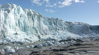
The Holocene glacial retreat is a geographical phenomenon that involved the global deglaciation of glaciers that previously had advanced during the Last Glacial Maximum. Ice sheet retreat initiated ca. 19,000 years ago and accelerated after ca. 15,000 years ago. The Holocene, starting with abrupt warming 11,700 years ago, resulted in rapid melting of the remaining ice sheets of North America and Europe. The retreat of glaciers altered landscapes in many ways and is currently still acting as a result of climate change.

Sanningasoq lake in Qeqqata, Greenland

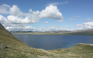
Sanningasoq is a large oligotrophic twin lake in central-western Greenland, in the Qeqqata municipality. It is located approximately 9 km (5.6 mi) northeast of Kangerlussuaq. It is characteristic in that it is composed of two lakes connected via a narrow water passage through a broken isthmus. Its northwestern shore is at 67°05′15″N50°39′50″W and its southeastern shore at 67°04′00″N50°28′53″W.

Qinnguata Kuussua river in Greenland

Qinnguata Kuussua is a river in a valley of the same name in the Qeqqata municipality in central-western Greenland. Its source is a large meltwater outflow from Russell Glacier flowing from the Greenland Ice Sheet. It is the main river in the Kangerlussuaq area. For most of its run, the river is very wide, up to 2 km (1.2 mi) in the upper reaches. The climate is polar continental, with the area receiving very little rainfall.

Kangerlussuaq Fjord Fjord Greenland, Qeqqata

Kangerlussuaq Fjord is a long fjord in the Qeqqata municipality in central-western Greenland. The fjord is 190 km (120 mi) long and between 1.5 km (0.93 mi) and 8 km (5.0 mi) wide, flowing from the estuary of Qinnguata Kuussua river to the southwest, and emptying into the Davis Strait. It is the longest fjord of western Greenland.

Maniitsoq Ice Cap glacier in Greenland

Maniitsoq Ice Cap is a 58 km × 41 km ice cap in the Qeqqata municipality in western Greenland.

Tarajornitsut mountain in Qeqqata Greenland

Tarajornitsut is an uninhabited tundra highland in the Qeqqata municipality in central-western Greenland, within the bounds of Kangaamiut dike swarm. The highland has many lakes, shallow valleys, hills, and wetlands, with plentiful wildlife, such as arctic geese. It is also a major calving ground for reindeer. In the future the area will become a protected nature reserve. The Polar Route from Sisimiut to Kangerlussuaq ends in Tarajornitsut, on the shore of Kangerlussuaq Fjord.

Majorqaq river in Greenland

Majorqaq is a meltwater river and valley of the same name in the Qeqqata municipality in central-western Greenland. It is one of the widest rivers in western Greenland, draining the Greenland ice sheet.

Tasersuaq is a large lake in the Qeqqata municipality in central-western Greenland. The name of the lake means large lake in the Greenlandic language, and is a common name shared by several lakes in the country.

References

  1. Allmetsat
  2. O'Carroll, Etain (2005). Greenland and the Arctic. Lonely Planet. p. 167. ISBN   1-74059-095-3.
  3. 1 2 Vandrekort Vestgrønland: Kangerlussuaq (Map) (1996 ed.). Cartography by Compukort, Denmark. Greenland Tourism a/s.
  4. Explore North, Volkswagen Testing Cars in Greenland