Itaka, Tanzania

Last updated

Itaka is an administrative ward in Mbozi District, Songwe Region, Tanzania.

Mbozi District is a district in Songwe Region, Tanzania. It is bordered to the north by Chunya District, to the east by Mbeya Urban and Ileje Districts, to the south by Zambia and to the west by Rukwa Region.

Songwe Region Region in Tanzania

Songwe is a region of Tanzania created on 29 January 2016 from the western half of Mbeya Region. Its capital is Vwawa.

Tanzania country in Africa

Tanzania officially the United Republic of Tanzania, is a country in eastern Africa within the African Great Lakes region. It borders Uganda to the north; Kenya to the northeast; Comoro Islands at the Indian Ocean to the east; Mozambique and Malawi to the south; Zambia to the southwest; and Rwanda, Burundi, and the Democratic Republic of the Congo to the west. Mount Kilimanjaro, Africa's highest mountain, is in north-eastern Tanzania.

Contents

Population

According to the 2002 census, the ward has a total population of 33,310. [1]

Religion

The Catholic Church of St. Thomas More is twinned with St. Augustine's Church in Leeds, UK. [2]

Catholic Church Christian church led by the Bishop of Rome

The Catholic Church, also known as the Roman Catholic Church, is the largest Christian church, with approximately 1.3 billion baptised Catholics worldwide as of 2017. As the world's "oldest continuously functioning international institution", it has played a prominent role in the history and development of Western civilisation. The church is headed by the Bishop of Rome, known as the Pope. Its central administration, the Holy See, is in the Vatican City, an enclave within the city of Rome in Italy.

Leeds City in England

Leeds is a city in West Yorkshire, England. Leeds has one of the most diverse economies of all the UK's main employment centres and has seen the fastest rate of private-sector jobs growth of any UK city. It also has the highest ratio of private to public sector jobs of all the UK's Core Cities, with 77% of its workforce working in the private sector. Leeds has the third-largest jobs total by local authority area, with 480,000 in employment and self-employment at the beginning of 2015. Leeds is ranked as a gamma world city by the Globalization and World Cities Research Network. Leeds is the cultural, financial and commercial heart of the West Yorkshire Urban Area. Leeds is served by four universities, and has the fourth largest student population in the country and the country's fourth largest urban economy.

Related Research Articles

Riverdale, Georgia City in Georgia, United States

Riverdale is a city in Clayton County, Georgia, United States. The population was 15,134 at the 2010 census, up from 12,478 in 2000. Riverdale is a suburb just south of Hartsfield–Jackson Atlanta International Airport and is part of the Atlanta metropolitan area.

Des Peres, Missouri City in Missouri, United States

Des Peres is a city in west St. Louis County, Missouri, United States. The population was 8,373 at the 2010 census.

Hatfield Township, Montgomery County, Pennsylvania Township in Pennsylvania, United States

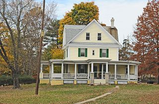
Hatfield Township is a township in Montgomery County, Pennsylvania, United States. The population was 17,249 at the 2010 census. It is part of the North Penn Valley region that is centered around the borough of Lansdale.

Menasha, Wisconsin City in Wisconsin, United States

Menasha is a city in Calumet and Winnebago counties in the U.S. state of Wisconsin. The population was 17,353 at the 2010 census. Of this, 15,144 were in Winnebago County, and 2,209 were in Calumet County. The city is located mostly in Winnebago County; only a small portion is in the Town of Harrison in Calumet County. Doty Island is located partially in Menasha. The city's name comes from the Winnebago word meaning "thorn" or "island". In the Menominee language, it is known as Menāēhsaeh, meaning "little island". Menasha is home to the Barlow Planetarium and Weis Earth Science Museum, both housed at the University of Wisconsin-Fox Valley.

Chilulumo is an administrative ward in Mbozi District, Songwe Region, Tanzania. According to 2002 census results, the ward has a total population of 13,388.

Kamsamba is an administrative ward in Mbozi District, Songwe Region, Tanzania. According to the 2002 census, the ward has a total population of 15,353.

Ivuna is an administrative ward in Mbozi District, Songwe Region, Tanzania. According to the 2002 census, the ward has a total population of 21,690.

Nambinzo is an administrative ward in Mbozi District, Songwe Region, Tanzania. According to the 2002 census, the ward has a total population of 18,769.

Isansa is an administrative ward in Mbozi District, Songwe Region, Tanzania. According to the 2002 census, the ward has a total population of 35,519.

Igamba is an administrative ward in Mbozi District, Songwe Region, Tanzania. According to the 2002 census, the ward has a total population of 29,596.

Halungu is an administrative ward in Mbozi District, Songwe Region, Tanzania. According to the 2002 census, the ward has a total population of 22,769.

Msia is an administrative ward in Mbozi District, Songwe Region, Tanzania. According to the 2002 census, the ward has a total population of 25,098.

Mlowo is an administrative ward in Mbozi District, Songwe Region, Tanzania. According to the 2002 census, the ward has a total population of 17,663.

Ihanda is an administrative ward in Mbozi District, Songwe Region, Tanzania. According to the 2002 census, the ward has a total population of 25,333.

Chiwezi is an administrative ward in Mbozi District, Songwe Region, Tanzania. According to the 2002 census, the ward has a total population of 12,657.

Msangano is an administrative ward in Mbozi District, Songwe Region, Tanzania. According to the 2002 census, the ward has a total population of 11,813.

Ndalambo is an administrative ward in Mbozi District, Songwe Region, Tanzania. According to the 2002 census, the ward has a total population of 9,029.

Myunga is an administrative ward in Mbozi District, Songwe Region, Tanzania. According to the 2002 census, the ward has a total population of 16,612.

Nkangamo is an administrative ward in Mbozi District, Songwe Region, Tanzania. According to the 2002 census, the ward has a total population of 8,122.

Ruanda is an administrative ward in Mbozi District, Songwe Region, Tanzania. According to the 2002 census, the ward has a total population of 15,614.

References

  1. "Population by Sex, Number of Households and Average Household Size". Government of Tanzania. Archived from the original on 2008-11-18. Retrieved 2008-08-18.
  2. St. Thomas More Parish, Itaka, Tanzania, accessed 7 April 2018

Coordinates: 8°52′16″S32°46′38″E / 8.8712°S 32.7772°E / -8.8712; 32.7772

Geographic coordinate system Coordinate system

A geographic coordinate system is a coordinate system that enables every location on Earth to be specified by a set of numbers, letters or symbols. The coordinates are often chosen such that one of the numbers represents a vertical position and two or three of the numbers represent a horizontal position; alternatively, a geographic position may be expressed in a combined three-dimensional Cartesian vector. A common choice of coordinates is latitude, longitude and elevation. To specify a location on a plane requires a map projection.