Related Research Articles

Pushmataha County is a county in the southeastern part of the U.S. state of Oklahoma. As of the 2010 census, the population was 11,572. Its county seat is Antlers.

Choctaw County is a county located in the U.S. state of Oklahoma. As of the 2010 census, the population was 15,205. Its county seat is Hugo.

The Kiamichi River is a river in southeastern Oklahoma, United States of America. A tributary of the Red River of the South, its headwaters rise on Pine Mountain in the Ouachita Mountains near the Arkansas border. From its source in LeFlore County, Oklahoma, it flows approximately 177 miles (285 km) to its confluence with the Red River south at Hugo, Oklahoma.
Kiamitia County, also known as Kiamichi County, was a political subdivision of the Choctaw Nation, Indian Territory. The county formed part of the nation's Pushmataha District, or Third District, one of three administrative super-regions.
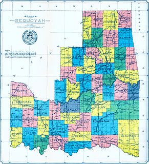
Hitchcock County was a proposed political subdivision created by the Sequoyah Constitutional Convention. The convention, meeting in Muskogee, Indian Territory in 1905, established the political and administrative layout of a prospective U.S. state it called the State of Sequoyah.
Cedar County was a political subdivision of the Choctaw Nation in the Indian Territory. The county formed part of the nation’s Apukshunnubbee District, or Second District, one of three administrative super-regions.
Jackson County was a political subdivision of the Choctaw Nation of Indian Territory, prior to Oklahoma being admitted as a state. The county formed part of the Nation's Pushmataha District, or Third District, one of three administrative super-regions.
Nashoba County was a political subdivision of the Choctaw Nation of Indian Territory. The county formed part of the Nation’s Apukshunnubbee District, or Second District, one of three administrative super-regions in the Nation. This territory was later made part of the state of Oklahoma.

Pushmataha District was one of three administrative super-regions comprising the former Choctaw Nation in the Indian Territory. Also called the Third District, it encompassed the southwestern one-third of the nation.
Blue County was a political subdivision of the Choctaw Nation of Indian Territory, prior to Oklahoma being admitted as a state. The county formed part of the Nation’s Pushmataha District, or Third District, one of three administrative super-regions.
Pushmataha County was a proposed political subdivision created by the Sequoyah Constitutional Convention. The convention, meeting in Muskogee, Indian Territory in 1905, established the political and administrative layout of a prospective U.S. state it called the State of Sequoyah.
Wade County was a political subdivision of the Choctaw Nation of Indian Territory, prior to Oklahoma being admitted as a state. The county formed part of the Nation's Apukshunnubbee District, or First District, one of three administrative super-regions.

Atoka County was a political subdivision of the Choctaw Nation of Indian Territory, prior to Oklahoma being admitted as a state. The county formed part of the Nation's Pushmataha District, or Third District, one of three administrative super-regions.
Towson County was a political subdivision of the Choctaw Nation of Indian Territory, prior to Oklahoma being admitted as a state. The county formed part of the Nation's Apukshunnubbee a District, or Second District, one of three administrative super-regions.
Bok Tuklo County was a political subdivision of the Choctaw Nation of Indian Territory, prior to Oklahoma being admitted as a state. The county formed part of the Nation’s Apukshunnubbee District, or Second District, one of three administrative super-regions. The subdivision was located within the current McCurtain County.
Bok Tuklo County was a political subdivision of the Choctaw Nation of Indian Territory, prior to Oklahoma being admitted as a state. The county formed part of the Nation’s Apukshunnubbee District, or Second District, one of three administrative super-regions.
Eagle County was a political subdivision of the Choctaw Nation of Indian Territory, prior to Oklahoma being admitted as a state. The county formed part of the Nation's Apukshunnubbee District, or Second District, one of three administrative super-regions.
Red River County was a political subdivision of the Choctaw Nation of Indian Territory, prior to Oklahoma being admitted as a state. The county formed part of the Nation's Apukshunnubbee District, or Second District, one of three administrative super-regions.
Sugar Loaf County was a political subdivision of the Choctaw Nation of Indian Territory, prior to Oklahoma being admitted as a state. The county formed part of the Nation's Moshulatubbee District, or First District, one of three administrative super-regions.
Gaines County was a political subdivision of the Choctaw Nation of Indian Territory, prior to Oklahoma being admitted as a state. The county formed part of the Nation's Moshulatubbee District, or First District, one of three administrative super-regions.
References
- ↑ George H. Shirk, Oklahoma Place Names, p. 74.
- ↑ "Organization of Counties in the Choctaw and Chickasaw Nations," Chronicles of Oklahoma, Vol. 8, No. 3, September 1930, pp. 317-318, 324.
- ↑ John W. Morris, Historical Atlas of Oklahoma, plates 38 & 56.
- ↑ Angie Debo, Rise and Fall of the Choctaw Republic, p. 152.