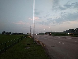
Jalan Boon Lay

Last updated

Jalan Boon Lay (Chinese :惹兰文礼) is a major road in Jurong West, Singapore. Travelling in a north-south direction, Jalan Boon Lay connects Jalan Bahar in the north with Jurong Pier Road in the south.

Chinese language family of languages

Chinese is a group of related, but in many cases not mutually intelligible, language varieties, forming the Sinitic branch of the Sino-Tibetan language family. Chinese is spoken by the ethnic Chinese majority and many minority ethnic groups in China. About 1.2 billion people speak some form of Chinese as their first language.

Jurong West Planning Area and HDB Town in West Region ----, Singapore

Jurong West is a planning area and residential town located in the West Region of Singapore. Jurong West shares boundaries with Tengah in the north, Jurong East in the east, Boon Lay and Pioneer in the south, and Western Water Catchment in the west.

Singapore Republic in Southeast Asia

Singapore, officially the Republic of Singapore, is an island city-state in Southeast Asia. It lies one degree north of the equator, at the southern tip of the Malay Peninsula, with Indonesia's Riau Islands to the south and Peninsular Malaysia to the north. Singapore's territory consists of one main island along with 62 other islets. Since independence, extensive land reclamation has increased its total size by 23%. The country is known for its transition from a developing to a developed one in a single generation under the leadership of its founder Lee Kuan Yew.

Contents

Etymology and history

The road was previously known as "Boon Lay Road" in the 1950s. [1] It was named after Chew Boon Lay (Chinese :周文礼; pinyin :Zhōu wén lǐ), one of Singapore's early pioneers and a successful businessman. The land in which Jalan Boon Lay and its adjacent areas once belonged to Chew and it was acquired by the colonial government sometime in the late 1940s and 1950s. [2]

Simplified Chinese characters standardized Chinese characters developed in mainland China

Simplified Chinese characters are standardized Chinese characters prescribed in the Table of General Standard Chinese Characters for use in mainland China. Along with traditional Chinese characters, they are one of the two standard character sets of the contemporary Chinese written language. The government of the People's Republic of China in mainland China has promoted them for use in printing since the 1950s and 1960s to encourage literacy. They are officially used in the People's Republic of China and Singapore.

Hanyu Pinyin, often abbreviated to pinyin, is the official romanization system for Standard Chinese in mainland China and to some extent in Taiwan. It is often used to teach Standard Mandarin Chinese, which is normally written using Chinese characters. The system includes four diacritics denoting tones. Pinyin without tone marks is used to spell Chinese names and words in languages written with the Latin alphabet, and also in certain computer input methods to enter Chinese characters.

During the 1960s, when Singapore became a state of Malaysia, it used the prefix "Jalan" and many other Malay roads were paved in the area as industrialization grew, including "Jalan Pabrik" (Renamed to "Jurong Port Road") and "Jalan Utasan" (Renamed to "International Road"). During this time, the road was realigned and a part of the old road was renamed "Jalan Boon Lay Lama". The part of it has since been defunct. [3]

Today

Located in the precinct of Boon Lay Place, Jalan Boon Lay is a major arterial road, linking Jalan Ahmad Ibrahim and Jalan Bahar. The road has spawn several other roads and landmarks named in Chew's honor, including "Boon Lay Way" and "Boon Lay Crescent" all located within Boon Lay Housing Estate. The road also serves as the western boundary of Boon Lay Place. The road currently features a mixture of industrial and housing estates and can get quite congested during peak hours, especially at the intersection of Boon Lay Way and Jalan Boon Lay.

Jalan Ahmad Ibrahim Place in Singapore

Jalan Ahmad Ibrahim is a road located in Boon Lay, Singapore. Named after Singaporean politician Ahmad Ibrahim, the road links Ayer Rajah Expressway with Jurong Hill Flyover.

Jalan Bahar is a major arterial road from Lim Chu Kang Road to Jurong West Avenue 2; originally a Jurong Road/Lim Chu Kang Road link. It was opened on 9 April 1965 to connect the rural areas of Lim Chu Kang to the Jurong Industrial Estate. It also connects through the Pan Island Expressway.

Landmarks

Landmarks located along Jalan Boon Lay include:

Singapore Technologies Kinetics Ltd , in Singapore, is a strategic business area of ST Engineering and handles land systems and specialty vehicles.

Related Research Articles

Lim Chu Kang Planning Area in North ----, Singapore

Lim Chu Kang is a planning area located in the northwestern part of the North Region of Singapore, bordering the Western Water Catchment to the west and south, Sungei Kadut to the east and the Straits of Johor to the north.

Boon Lay Place in Singapore

Boon Lay, is a neighbourhood located in the town of Jurong West in the West Region of Singapore. Its borders very roughly correspond to the URA subzone of Boon Lay Place, situated within the Jurong West Planning Area.

Yunnan, Singapore Place in Singapore

Yunnan is a subzone located in the town of Jurong West in the West Region of Singapore.

Jurong West Central Place in Singapore

Jurong West Central is a subzone of Jurong West, located in the West Region of Singapore. This is the town centre of Jurong West.

Jalan Bukit Merah is a major arterial road in Singapore. The road starts from Queensway in the west before ending at Kampong Bahru Road.

Tengah is a planning area and future HDB town located within the West Region of Singapore. It is bounded to by Choa Chu Kang to the northeast, Jurong East and Jurong West to the south, Bukit Batok to the east and the Western Water Catchment to its west and north.

Wenya is a subzone of Jurong West, Singapore.

Geylang Bahru Subzone of Kallang Planning Area in Central Region, Singapore

Geylang Bahru is a subzone within the planning area of Kallang, Singapore, as defined by the Urban Redevelopment Authority (URA). It is bounded by the Pan Island Expressway (PIE) in the east; the Pelton Canal in the south; the Kallang River in the west; and Serangoon Road in the north.

Pulau Samulun Subzone of Boon Lay Planning Area in Singapore

Pulau Samulun is an offshore island in Jurong Industrial Estate, Singapore. It is separated from mainland Singapore by Selat Samulun. It is only less than a kilometre away from Singapore mainland. Jurong Shipyard is located in Pulau Samulun and it also houses a food centre that caters to the workers working there. Samulun is from "sembulun" a tribe of Orang Laut who once lived here.

Boon Lay Single Member Constituency is a former single member constituency in Boon Lay, Singapore that was formed in 1976 til 2001 where the then incumbent Goh Chee Wee had retired from politics which consequently, this ward was subsequently absorbed into West Coast GRC. It carved out of Jurong constituency.

Chin Bee is an area in Jurong Industrial Estate in Singapore, bounded by Boon Lay Way, Jalan Boon Lay, Ayer Rajah Expressway and Corporation Road.

Dato' Toh Ah Boon was a Chinese community leader, and one of the biggest landlords in Johor Bahru of his time. He was born in Singapore but died in Johor Bahru's house in 90, Jalan Ibrahim, Johor Bahru. He was honored by Late Johor Sultan the SPMJ Dato and DPMJ Dato.

Boon Lay is a planning area located in the West Region of Singapore. The planning area is bounded by the planning areas of Pioneer to the west, Jurong West to the north, Jurong East to the east and the strait of Selat Jurong to the south.

Boon Lay Way is a major road in Jurong, Singapore, that goes from Commonwealth Avenue West all the way to Upper Jurong Road via the Jurong East and the Jurong West New Towns.

Jalan Buroh is a major arterial road in western Singapore. It runs along the industrial areas of Pandan, Tanjong Penjuru and Pioneer.

Jurong Pier MRT station (JS12) is a proposed Mass Rapid Transit (MRT) station on the Jurong Region Line, located on the boundary of Boon Lay and Jurong East planning areas in Singapore. It is planned to open during stage 3 of the line in 2028.

References

  1. http://hm.onemap.sg/1954/1954%20(108).jpg
  2. http://eresources.nlb.gov.sg/infopedia/articles/SIP_1496_2009-04-03.html
  3. http://hm.onemap.sg/1966/1966%20(108).jpg