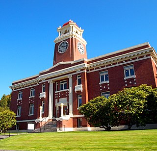
Clallam County is a county in the U.S. state of Washington. As of the 2020 census, the population was 77,155, with an estimated population of 77,805 in 2022. The county seat and largest city is Port Angeles; the county as a whole comprises the Port Angeles, WA Micropolitan Statistical Area. The name is a Klallam word for "the strong people". The county was formed on April 26, 1854. Located on the Olympic Peninsula, it is south from the Strait of Juan de Fuca, which forms the Canada–US border, as British Columbia's Vancouver Island is across the strait.

Blyn is a census-designated place (CDP) in Clallam County, Washington, United States. The population was 101 at the 2010 census, down from 162 at the 2000 census. It is located near the city of Sequim on the shores of Sequim Bay. The area includes the Jamestown S'Klallam Indian Reservation, established in 1874 by the Jamestown S'Klallam Tribe, who named the community Jamestown.

Sequim is a city in Clallam County, Washington, United States. It is located along the Dungeness River near the base of the Olympic Mountains. The 2020 census counted a population of 8,018, with an estimated population in 2021 of 8,241.
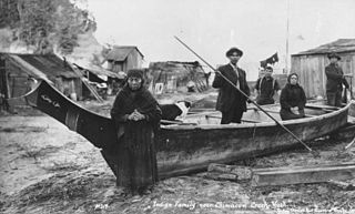
Klallam refers to four related indigenous Native American/First Nations communities from the Pacific Northwest of North America. The Klallam culture is classified ethnographically and linguistically in the Coast Salish subgroup. Two Klallam bands live on the Olympic Peninsula and one on the Kitsap Peninsula in Washington state, and one is based at Becher Bay on southern Vancouver Island in British Columbia.

The Hoh or Chalá·at are a Native American tribe in western Washington state in the United States. The tribe lives on the Pacific Coast of Washington on the Olympic Peninsula. The Hoh moved onto the Hoh Indian Reservation, 47°44′31″N124°25′17″W at the mouth of the Hoh River, on the Pacific Coast of Jefferson County, after the signing of the Quinault Treaty on July 1, 1855. The reservation has a land area of 1.929 square kilometres and a 2000 census resident population of 102 persons, 81 of whom were Native Americans. It lies about halfway between its nearest outside communities of Forks, to its north, and Queets, to its south. The river is central to their culture. The main resources they used included cedar trees, salmon, and the nearby vegetation. They also traded and bartered with other tribes closer to Eastern Washington, near the Plateaus and Great Plains.

The Olympic Peninsula is a large arm of land in western Washington that lies across Puget Sound from Seattle, and contains Olympic National Park. It is bounded on the west by the Pacific Ocean, the north by the Strait of Juan de Fuca, and the east by Hood Canal. Cape Alava, the westernmost point in the contiguous United States, and Cape Flattery, the northwesternmost point, are on the peninsula. Comprising about 3,600 square miles (9,300 km2), the Olympic Peninsula contained many of the last unexplored places in the contiguous United States. It remained largely unmapped until Arthur Dodwell and Theodore Rixon mapped most of its topography and timber resources between 1898 and 1900.
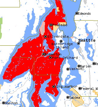
The Kitsap Peninsula lies west of Seattle across Puget Sound, in Washington state in the Pacific Northwest. Hood Canal separates the peninsula from the Olympic Peninsula on its west side. The peninsula, a.k.a. "Kitsap", encompasses all of Kitsap County except Bainbridge and Blake Islands, as well as the northeastern part of Mason County and the northwestern part of Pierce County. The highest point on the Kitsap Peninsula is Gold Mountain. The U.S. Navy's Puget Sound Naval Shipyard, and Naval Base Kitsap are on the peninsula. Its main city is Bremerton.

The Chimakum, also spelled Chemakum and Chimacum Native American people, who lived in the northeastern portion of the Olympic Peninsula in Washington state, between Hood Canal and Discovery Bay until their virtual extinction in 1902. Their primary settlements were on Port Townsend Bay, on the Quimper Peninsula, and Port Ludlow Bay to the south.

Klallam,Clallam, Ns'Klallam or S'klallam, is a Straits Salishan language that was traditionally spoken by the Klallam peoples at Becher Bay on Vancouver Island in British Columbia and across the Strait of Juan de Fuca on the north coast of the Olympic Peninsula in Washington. The last speaker of Klallam as a first language died in 2014, but there is a growing group of speakers of Klallam as a second language.
Dungeness is an unincorporated community in Clallam County, Washington, United States, located north of Sequim and on the Strait of Juan de Fuca. Dungeness has a number of waterfront residential communities, but also features the Dungeness Spit, a popular destination for locals and tourists. The name "Dungeness" refers to the Dungeness headland in England. It was given by George Vancouver in 1792, who wrote: "The low sandy point of land, which from its great resemblance to Dungeness in the English Channel, It is called New Dungeness."
Jamestown is an unincorporated community and census-designated place (CDP) in Clallam County, Washington, United States. The population was 361 at the 2010 census.
Little Boston is a community in Kitsap County, Washington, United States. It is located on the east side of Port Gamble, an inlet or bay of Hood Canal, and is direct across the bay from the unincorporated community of Port Gamble. Little Boston is within the Port Gamble Indian Reservation, which houses the Port Gamble band of the S'Klallam tribe.
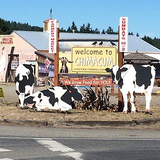
Chimacum is an unincorporated community in Jefferson County, Washington, United States, located in the center of the primary agricultural area of the eastern Olympic Peninsula. It was named after the Chimakum group of Indigenous Americans that lived there until the late 19th century but are now extinct as a distinct cultural group. Chimacum Creek is named after the Chimakum, a Native American people known to themselves as Aqokúlo, who lived on the northeastern portion of the Olympic Peninsula through the mid-19th century and whose economy, culture and religion were based on salmon fishing. Their primary settlements were on Port Townsend Bay, on the Quimper Peninsula, and Port Ludlow Bay to the south. According to tradition, the Chimakum were a remnant of a Quileute band who had been carried away in their canoes by a great flood through a passageway in the Olympic Mountains and deposited on the other side of the peninsula. In 1855 the Twana and Chimakum, along with the Klallam, signed the Point No Point Treaty, which established a reservation at the mouth of the Skokomish River near the southern end of Hood Canal. One of the Chimakum signatories of the treaty was Chief Kulkakhan, also known as General Pierce. After this, most Chimakum people merged into the S’Klallam and Skokomish tribes, where their descendants still live today.

The SequimMuseum & Arts, located in downtown Sequim, Washington, is a free-admission local history museum. Founded in 1976, the museum is home to the Manis Mastodon tusks and bones which were found at an early human encampment located on the present day Manis Farm, famous as one of the first-known contact between humans with a mastodon 13,000 years ago.

The Lower Elwha Klallam Tribe is a federally recognized Native American nation in the Pacific Northwest of the United States. The tribe is part of the larger Klallam culture, part of the Coast Salish people.

The Olympic Discovery Trail is a rail trail spanning the north end of the Olympic Peninsula in Washington. The route is designated as a multi-use trail and spans 135 miles (217 km) between Port Townsend and La Push on the Pacific Coast. As of 2021, 90 miles (140 km) of the trail have been developed into a complete path. The remainder of the route can be ridden using a combination of public roads.
Adeline Smith was an American elder, lexicographer, activist, and cultural preservationist. She was a member of one of four indigenous Klallam communities of the Pacific Northwest.
The Port Gamble S'Klallam Tribe, formerly known as the Port Gamble Indian Community of the Port Gamble Reservation or the Port Gamble Band of S'Klallam Indians is a federally recognized tribe of S'Klallam people, located on the Kitsap Peninsula in Washington. They are an Indigenous peoples of the Northwest Coast.
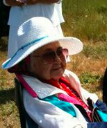
Hazel M. Sampson was an American Klallam elder and language preservationist. Sampson was the last native speaker of the Klallam language, as well as the oldest member of the Klallam communities at the time of her death in 2014. She was a member of the Jamestown S'Klallam Tribe of Washington.
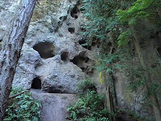
Tamanowas Rock, also called Chimacum Rock, is a 150-foot (46 m) high rock with caves and crevices that lies in a forest adjacent to Anderson Lake State Park, near Port Townsend, Washington. It is a sacred site to the Coast Salish peoples of the Pacific Northwest and a pilgrimage site. The rock was listed on the National Register of Historic Places in 2015.

