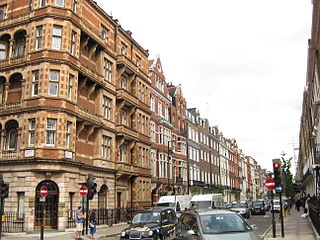
John Prince's Street, also Princes Street, is a street in Marylebone in the City of Westminster in central London that runs from Margaret Street in the north to Oxford Street in the south. It is joined on its eastern side by Great Castle Street.
John Prince's Street, also Princes Street, is a street in Marylebone in the City of Westminster in central London that runs from Margaret Street in the north to Oxford Street in the south. It is joined on its eastern side by Great Castle Street.

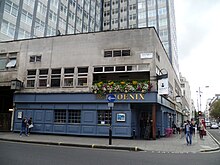
The street was one of those laid out around 1729 [1] when the area north of Oxford Street was urbanised on a grid pattern. It was named after John Prince, an employee of Edward Harley after whom Harley Street was named and who owned the land. Harley employed John Prince to lay out the streets on the Harley estate and John's Prince's Street was one of the first set out. Contemporary newspaper the Morning Advertiser , described Prince as vain and arrogant and a self-styled "Prince of Builders". [2] The cul-de-sac Phoenix Yard once ran from the western side, opposite Great Castle Street, into the centre of what is now the London College of Fashion and BHS.
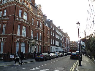
Once the location of small shops and houses, the street is now taken up by the London College of Fashion and the former British Home Stores department store (1962–63) [3] on the western side and small retail premises on the eastern side. The Phoenix public house is at the north end on the western side on the corner with Margaret Street.

Charing Cross Road is a street in central London running immediately north of St Martin-in-the-Fields to St Giles Circus, which then merges into Tottenham Court Road. It leads from the north in the direction of Charing Cross at the south side of Trafalgar Square. It connects via St Martin's Place and the motorised east side of the square.

Fitzrovia is a district of central London, England, near the West End. The eastern part of the area is in the London Borough of Camden, and the western in the City of Westminster. It has its roots in the Manor of Tottenham Court, and was urbanised in the 18th century. Its name was coined in the late 1930s by Tom Driberg.
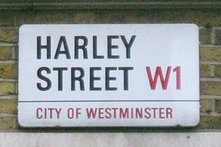
Harley Street is a street in Marylebone, Central London, named after Edward Harley, 2nd Earl of Oxford and Earl Mortimer. Since the 19th century it has housed a large number of private specialists in medicine and surgery.
Great Portland Street is a road in the West End of London which links Oxford Street with the A501 Marylebone Road. A commercial street, it divides Fitzrovia, to the east, from Marylebone to the west. It delineates areas with contrasting identities, the west at strongest in grandiose Portland Place and Harley Street, the east at strongest in artists' and independent businesses of Fitzrovia.

The City and Liberty of Westminster was a unit of local government in the county of Middlesex, England. It was located immediately to the west of the City of London. Originally under the control of Westminster Abbey, the local authority for the area was the Westminster Court of Burgesses from 1585 to 1900. The area now forms the southern part of the City of Westminster in Greater London.

Wigmore Street is a street in the City of Westminster, in the West End of London. The street runs for about 600 yards parallel and to the north of Oxford Street between Portman Square to the west and Cavendish Square to the east. It is named after the village of Wigmore and its castle in Herefordshire, a seat of the family of Robert Harley, politician around the time of Queen Anne, who owned land in the area.

Great Titchfield Street is a street in the West End of London. It runs north from Oxford Street to Greenwell Street, just short of the busy A501 Marylebone Road and Euston Road. It lies within the informally designated London area of Fitzrovia. In administrative terms it is in the City of Westminster. It lies within their designated East Marylebone Conservation Area in the former Metropolitan Borough of St Marylebone.

Cavendish Square is a public garden square in Marylebone in the West End of London. It has a double-helix underground commercial car park. Its northern road forms ends of four streets: of Wigmore Street that runs to Portman Square in the much larger Portman Estate to the west; of Harley Street which runs an alike distance; of Chandos Street which runs for one block and; of Cavendish Place which runs the same. The south side itself is modern: the rear façade and accesses to a flagship department store and office block. On the ground floors facing are Comptoir Libanais, Royal Bank of Scotland and Pret a Manger premises.

Marylebone is an area in London, England and is located in the City of Westminster. It is in Central London and part of the West End. Oxford Street forms its southern boundary.
Portland Place is a street in the Marylebone district of central London. Named after the 3rd Duke of Portland, the unusually wide street is home to the BBC's headquarters Broadcasting House, the Chinese and Polish embassies, the Royal Institute of British Architects and numerous residential mansion blocks.
The Howard de Walden Estate is a property estate in Marylebone, London, owned by the Howard de Walden family. As of 2020 the estate was reported to be worth £4.7 billion.

Weymouth Street lies in the Marylebone district of the City of Westminster and connects Marylebone High Street with Great Portland Street. The area was developed in the late 18th century by Henrietta Cavendish Holles and her husband Edward Harley, 2nd Earl of Oxford. This part of Marylebone was noted to part of Manor of Tyburn and dates back to the year 1086.

Gresse Street is a street in London that is on the border between the City of Westminster and the London Borough of Camden, the north and eastern sides being in Camden and the rest in Westminster.

Marylebone Lane is one of the original streets of the Marylebone district of the City of Westminster, London. It runs from Oxford Street in the south to Marylebone High Street in the north, its winding shape following the course of the River Tyburn that it once ran alongside and pre-dating the grid pattern of the other streets in the area. Today the lane is largely composed of small shops, cafes and restaurants with some small apartment blocks. There are some larger commercial buildings at the southern end near Oxford Street.
Bulstrode Street is a street in Marylebone in the City of Westminster that runs from Welbeck Street in the east to Thayer Street in the west. It is crossed only by Marylebone Lane.

Henrietta Place, originally known as Henrietta Street, is a street in Marylebone in the City of Westminster in central London that runs from Marylebone Lane in the east to Cavendish Square in the west. It is joined on the north side by Welbeck Street and Wimpole Street, and on the south side by Vere Street, Chapel Place, and Old Cavendish Street.
Old Cavendish Street, originally Cavendish Street, is a street in Marylebone in the City of Westminster in central London that runs from Henrietta Place in the north to Oxford Street in the south.

Holles Street is a street in Marylebone in the City of Westminster in central London that runs from the south side of Cavendish Square to Oxford Street.

Wells Street is a street in the City of Westminster. It runs from Riding House Street in the north to Oxford Street in the south. It is crossed by Mortimer Street and Eastcastle Street. It is joined on its western side by Marylebone Passage and on the eastern side by Booth's Place and Wells Mews.

Margaret Street is a street that straddles the Marylebone and Fitzrovia areas of the City of Westminster in the West End of London, running from Cavendish Square to Wells Street via Regent Street (A4201), Great Portland Street, and Great Titchfield Street. It is north of and parallel to the major shopping street, Oxford Street. John Prince's Street runs between Margaret Street and Oxford Street.
51°30′57″N0°08′35″W / 51.5157°N 0.1430°W
| | This London road or road transport-related article is a stub. You can help Wikipedia by expanding it. |