June 2020 Pennsylvania–New Jersey derecho

Last updated

June 2020 Pennsylvania–New Jersey derecho
June-2020-derecho.png
A radar composite image of the derecho
Date(s)Wednesday, June 3, 2020
Track length350 mi (563 km)
Peak wind gust  (measured)93 mph (150 km/h; 41.6 m/s)(Beach Haven, New Jersey)
Fatalities4

On the morning and into the early afternoon of June 3, 2020, a powerful derecho crossed the U.S. states of Pennsylvania and New Jersey, resulting in four fatalities. It was the deadliest derecho event in the region since 1950.

Contents

The storms were part of a mesoscale convective system which formed just outside of Oil City, Pennsylvania, and began moving eastward across Lake Erie just after 5 a.m. (EDT). The Storm Prediction Center made its first warning around 8:30 a.m., and damaging wind reports began about 20 minutes later. A severe thunderstorm watch was put into effect in the region just after 10 a.m., as warm, humid temperatures further destabilized the squall line. By the time that the storm crossed the Delaware River into New Jersey, wind speeds were equivalent to those of a Category 1 hurricane. By 2 a.m., the storm had dissipated offshore.

Fallen trees and power lines resulted in four deaths across southeastern Pennsylvania. Wind speeds also resulted in severe property damage from fallen trees, and at least two buildings lost their roofs. Over 850,000 individuals lost electricity due to storm damage, and for many, power was not restored for several days. PECO Energy recruited service crews from outside the region to work on restoring electricity to homes, while drone technology was used to survey the damage. Repairs were slowed by several days of thunderstorms following the initial storm, but by June 6, the severe weather had come to an end.

Meteorological history

A mesoscale convective system that formed just outside of Oil City, Pennsylvania, [1] began moving eastward across Lake Erie around 5:12 a.m. EDT on the morning of June 3, 2020. [2] By 8:32 a.m. EDT, the storm system had moved into northwestern Pennsylvania, and the Storm Prediction Center (SPC) warned that as it progressed and encountered the warmer temperatures in the eastern part of the state, there was a greater threat of severe weather. [3] The first reports of damaging winds emerged twenty minutes later. [1] The SPC issued its first severe thunderstorm watch at 10:05 a.m. EDT, covering an area that stretched from 35 miles (56 km) west-northwest of State College, Pennsylvania, and 30 miles (48 km) southeast of Lakehurst, New Jersey, as well as 60 miles (97 km) north and south. [4] By 10:34 a.m. EDT, the squall line was moving into southeastern Pennsylvania, where the warm, humid temperatures would further destabilize the system. [5]

While there were few damaging wind gusts of 60 mph (97 km/h) or more while the storm moved across western and central Pennsylvania in the morning, the storm intensified by noon. Significant wind damage began as the system entered Berks County, Pennsylvania, and continued through the Delaware Valley towards Ocean County, New Jersey. [6] The 83 mph (134 km/h) wind gust measured in Berks was the strongest on record, surpassing the 82 mph (132 km/h) gusts recorded during Hurricane Hazel. [7] Social media footage from the storm showed funnel clouds in Philadelphia and hail in State College, Pennsylvania. [8] The storm crossed the Delaware River around 12:30 p.m. EDT and reached Long Beach Island by 1:15 p.m. The derecho was most severe in Ocean County, New Jersey, where wind speeds were measured at 93 mph (150 km/h) in Beach Haven and 92 mph (148 km/h) in Surf City. [1] By 2 p.m. EDT, the storm had moved off of the New Jersey coast. [6]

Wind speeds reached in New Jersey were equivalent to a Category 1 hurricane, but no hurricane, tropical storm, or tornado was recorded. [9] To be considered a derecho, the National Weather Service states that wind damage must extend at least 240 miles (390 km) and include gusts of at least 58 mph (93 km/h). An early report from climatologist David Robinson inferred that the storm had traveled 350 miles (560 km) in 5+12 hours, which would have given it an average speed of 65 mph (105 km/h). [10] Derecho storms are also known for the characteristic bow-like shape of their radar profile [11] The SPC confirmed on the afternoon of June 3 that the storm was classified as a derecho. [12] Meteorologist Lee Robertson believed that the storm was rare even among other derecho events both for its "duration and intensity", particularly the wind speeds of 80 to 90 mph (130 to 140 km/h). [9] The evening before, a "ring of fire" pattern had settled over most of the contiguous United States. In such a scenario, thunderstorms moving across the ridge of a high-pressure area feed off of both the warm, humid air of the high-pressure region and the adjacent jet stream winds, causing rapidly-intensifying, unpredictable storms. [13] In the days preceding the derecho, that weather pattern had caused damaging thunderstorms in the Midwestern United States. [11]

After the initial derecho passed, the warm weather returned to the region, allowing for more atmospheric destabilization and another set of thunderstorms that evening. [6] Around 3:10 p.m. EDT, an outflow-modified cold front formed over south-central Kentucky, northwest Pennsylvania, and central Ohio, carrying the risk of isolated wind gusts, hail, and scattered thunderstorms. [14] A second severe thunderstorm watch was issued for the Mid-Atlantic region at 3:50 p.m. EDT, covering an area 5 miles (8.0 km) north-northwest of State College to 15 miles (24 km) east-northeast of Atlantic City, New Jersey, and extending 40 miles (64 km) north and south, respectively. [15] Bill Bunting of the SPC characterized the later thunderstorms by their "strobe-like lightning, and prolonged thunder that evoked an oceanic roar", and the rains were heavier in the later, slower storm than they had been for the faster derecho. [16] The evening storm also caused damage in areas of New Jersey, including Beach Haven, Hammonton, Folsom, Port Republic, and Mullica Township. [17] A tornado warning was issued in southern New Jersey and southeastern Pennsylvania at 7:15 p.m. and expired 30 minutes later. [18] At 8:30 p.m., The Philadelphia Inquirer reported that there had been no confirmed tornado reports in the region. [19] In Carlisle, Pennsylvania, which had avoided damage from the initial derecho, a microburst (a sudden strong, spreading downdraft) later in the evening caused extensive damage to trees and power lines. [20] The remaining storms dissipated offshore by 10 p.m. EDT, concluding the severe weather for the day. [6]

Impact

Downed tree branch and damaged power lines caused by the derecho in Hatboro, Pennsylvania Downed tree branch and damaged power lines from 6-3-2020 derecho Hatboro PA.jpeg
Downed tree branch and damaged power lines caused by the derecho in Hatboro, Pennsylvania

The June 2020 derecho was the first to impact the Pennsylvania–New Jersey region since June 2012, when a storm moved east from Iowa into southern Pennsylvania. [21] Four fatalities were associated with the derecho, making it the deadliest such storm in the region since 1950. [6] In Belmont Hills and Penn Wynne, Pennsylvania, respectively, two individuals were killed when trees fell onto the roofs of their cars. [9] In Lower Moreland Township, the 38-year-old director of golf at Philmont Country Club was killed when a tree collapsed into the building where he had been working. [22] The fourth fatality occurred in Delaware County, where derecho winds topped live overhead power lines into a home, causing the building to catch fire. A second individual inside the house escaped. [23]

In addition to human death and injury, the derecho caused extensive property damage as trees were uprooted from the ground, landing on and crushing homes and vehicles. [24] The National Weather Service office in Mount Holly, New Jersey, logged over 250 wind damage reports in the region resulting from the derecho, most resulting from felled trees and downed power lines, some of which collapsed on buildings and residences. [11] Most of the damage was concentrated in a stretch from Reading, Pennsylvania, to Philadelphia, with areas such as the Lehigh Valley spared the brunt of the storm. [25] In Lansdale, Pennsylvania, the storm removed the roof from a 150-unit apartment building, leaving the complex uninhabitable. [26] [27] A report from the Montgomery County board of commissioners also stated that the storm had caused several serious fires in the region. [28] On Long Beach Island, the St. Francis Community Center also lost part of its roof to derecho winds. [29]

The storm also caused massive power outages in southeastern Pennsylvania and New Jersey. More than 850,000 individuals lost electricity on June 3, [30] including 200,000 in New Jersey. [31] Several long-term care facilities in Montgomery County, Pennsylvania lost electricity and utilized emergency generators to protect the residents. [27] The following day, around 100,000 homes and businesses in New Jersey remained without power. Most of the outages were located in Burlington and Camden County, New Jersey. [31] In Pennsylvania, over 56,000 individuals remained without power on June 5. [32] Although the number dwindled to 16,500 on Sunday, June 6, PECO Energy received several complaints from those individuals about their lack of electricity during a period of high temperatures, as well as the company's delayed time frames for when their electricity might be restored. [30] PECO Energy recruited service crews from states including Oklahoma, Illinois, Florida, and New Hampshire to undertake repairs and restorations. [32] PECO, who had been using drone technology for several months prior to the storm but had been seeking opportunities to incorporate the technology into storm restoration, used their drones to assess damage aerially at speeds that would have been much slower from the ground. All power was restored by June 9. [33]

Aftermath

Repairing the damage caused by the derecho was inhibited by additional severe thunderstorms in the following days. [34] [35] The National Weather Service and local meteorologists warned that "several rounds of progressive thunderstorm complexes" would extend through the Lehigh Valley until the storm front was displaced by an east-to-west boundary on June 6. [36] On June 4, the NWS warned that another round of thunderstorms would move through central Pennsylvania after 4 p.m. EDT, continuing through the night with a possibility of flooding. [37] A loose series of storms passed through New Jersey that afternoon, dissipating just after midnight. [38] Areas of Middlesex and Monmouth County were placed under a coastal flood advisory from 6 p.m. to midnight, with the NWS predicting up to 1 foot (0.30 m) of flooding above ground level. [34]

Another round of slow-moving thunderstorms passed through the region on June 5, with most of New Jersey and southeastern Pennsylvania placed under a flash flood watch. [39] Areas of northern Delaware and Maryland were also placed under watch. [40] Unlike the wind damage caused by the derecho, heavy rainfall provided a greater threat for this later day of severe weather. [41] Thunderstorms passed over the region between 3 and 10 p.m. EDT, with places like Wall Township, New Jersey, receiving 4.24 inches (108 mm) of rain in one day, more than the town's usual monthly total of 3.98 inches (101 mm) of June precipitation. [42] Flooding was reported in Pennsylvania as well, particularly around the Schuylkill Expressway, Route 202 in Chester County, and around the Delaware River, where a flood advisory was triggered. [32] The severe weather in the Pennsylvania–New Jersey area abated by the weekend of June 6, with temperatures leveling out at around 80 °F (27 °C) and with no storms. [43]

See also

Related Research Articles

<span class="mw-page-title-main">Mesocyclone</span> Region of rotation within a powerful thunderstorm

A mesocyclone is a meso-gamma mesoscale region of rotation (vortex), typically around 2 to 6 mi in diameter, most often noticed on radar within thunderstorms. In the northern hemisphere it is usually located in the right rear flank of a supercell, or often on the eastern, or leading, flank of a high-precipitation variety of supercell. The area overlaid by a mesocyclone’s circulation may be several miles (km) wide, but substantially larger than any tornado that may develop within it, and it is within mesocyclones that intense tornadoes form.

<span class="mw-page-title-main">Severe thunderstorm watch</span> Weather watch indicating conditions favorable for the development of severe thunderstorms

A severe thunderstorm watch is a statement issued by weather forecasting agencies to advise the public that atmospheric conditions in a given region may lead to the development of severe thunderstorms within the region over several hours. The criteria for issuing a watch varies from country to country and may also include torrential rainfall and tornadoes. A watch may also be issued several hours ahead of the arrival of a mature and organized complex of storms, such as a mesoscale convective system.

<span class="mw-page-title-main">Squall line</span> Line of thunderstorms along or ahead of a cold front

A squall line, or more accurately a quasi-linear convective system (QLCS), is a line of thunderstorms, often forming along or ahead of a cold front. In the early 20th century, the term was used as a synonym for cold front. Linear thunderstorm structures often contain heavy precipitation, hail, frequent lightning, strong straight-line winds, and occasionally tornadoes or waterspouts. Particularly strong straight-line winds can occur where the linear structure forms into the shape of a bow echo. Tornadoes can occur along waves within a line echo wave pattern (LEWP), where mesoscale low-pressure areas are present. Some bow echoes can grow to become derechos as they move swiftly across a large area. On the back edge of the rainband associated with mature squall lines, a wake low can be present, on very rare occasions associated with a heat burst.

<span class="mw-page-title-main">Storm Prediction Center</span> American severe weather forecasting center

The Storm Prediction Center (SPC) is a US government agency that is part of the National Centers for Environmental Prediction (NCEP), operating under the control of the National Weather Service (NWS), which in turn is part of the National Oceanic and Atmospheric Administration (NOAA) of the United States Department of Commerce (DoC).

<span class="mw-page-title-main">Derecho</span> Widespread, long-lived, straight-line wind storm

A derecho is a widespread, long-lived, straight-line wind storm that is associated with a fast-moving group of severe thunderstorms known as a mesoscale convective system.

<span class="mw-page-title-main">New York State Labor Day derechos</span> Derecho events in New York state

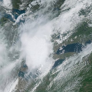
The New York State Labor Day Derechos were two derecho events that occurred on Labor Day, September 7, 1998. One derecho moved through northern and central New York state, and the other would start in southeastern Michigan and move through northeastern Ohio, Pennsylvania, New Jersey, and Long Island. A spokesman for the New York State Emergency Management Office, estimated that 300,000 residences had lost electricity, 7 persons died and 80 were injured.

<span class="mw-page-title-main">1991 West Virginia derecho</span> Weather event

<span class="mw-page-title-main">Bow echo</span> Mesoscale convective system shaped like a archers bow

A bow echo is the characteristic radar return from a mesoscale convective system that is shaped like an archer's bow. These systems can produce severe straight-line winds and occasionally tornadoes, causing major damage. They can also become derechos or form Line echo wave pattern (LEWP).

The heat wave of 2006 derecho series were a set of derechos — severe winds with powerful thunderstorms — that occurred on July 17–21, 2006. The first storms hit a wide swath of north-central and northeastern North America that stretched from the Upper Midwest through much of Ontario and into the northeastern United States. Another round struck the middle Mississippi River Valley, including two derechos that hit St. Louis, Missouri. The storms left more than three million people without power, some more than once and some for weeks.

<span class="mw-page-title-main">February 2009 North American storm complex</span> 2009 storm complex in the United States

On February 10–11, 2009, a broad-scale damaging wind event and small tornado outbreak affected the Central and Eastern United States. During the two-day period, 14 tornadoes touched down in seven states. Oklahoma was struck by six tornadoes, the most of any state. The six tornadoes in Oklahoma also tied the record for the most tornadoes ever recorded in the state during the month of February, which would later be broken in 2023. The first day of the outbreak produced the most tornadoes; the second brought mainly high wind damage and rain or snow in most of the Northeast.

A mesovortex is a small-scale rotational feature found in a convective storm, such as a quasi-linear convective system, a supercell, or the eyewall of a tropical cyclone. Mesovortices range in diameter from tens of miles to a mile or less and can be immensely intense.

<span class="mw-page-title-main">2010 Bronx tornado</span>

The 2010 Bronx tornado was a rare EF1 tornado which struck the Bronx in New York City, United States, touching down there on July 25, 2010 and traveled 1 mi (1.6 km). The tornado, which was the second ever tornado recorded in the Bronx, touched down around 2:55 p.m. EDT in Riverdale, located within the Bronx, causing damage to buildings, trees, cars, and power lines. Seven people were injured along its track due to broken glass. The tornado lifted around 3:00 p.m. EDT while still within the Riverdale neighborhood.

<span class="mw-page-title-main">June 2012 North American derecho</span> Weather event

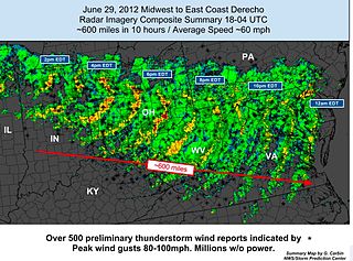
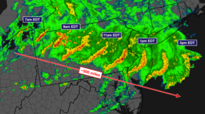
The June 2012 Mid-Atlantic and Midwest derecho was one of the deadliest and most destructive fast-moving severe thunderstorm complexes in North American history. The progressive derecho tracked across a large section of the Midwestern United States and across the central Appalachians into the mid-Atlantic states on the afternoon and evening of June 29, 2012, and into the early morning of June 30, 2012. It resulted in a total of 22 deaths, millions of power outages across the entire affected region, and a damage total of US$2.9 billion which exceeded that of all other derecho events aside from the August 2020 Midwest derecho. The storm prompted the issuance of four separate severe thunderstorm watches by the Storm Prediction Center. A second storm in the late afternoon caused another watch to be issued across Iowa and Illinois.

<span class="mw-page-title-main">June 12–13, 2013, derecho series</span> Series of weather events

From June 12 to June 13, 2013, two derechos occurred across different areas of the Eastern United States. The initial derecho formed on the afternoon of June 12 and tracked across a large section of the Midwestern United States, the central Appalachians, and the Mid-Atlantic states before moving into the Atlantic Ocean during the morning of June 13. A second, more widespread and intense derecho occurred on June 13 across the Southeastern United States, resulting in major wind damage across North Carolina, Virginia, and Maryland, among other states. These storms caused at least three deaths and extensive damage property damage – resulting from both tornadoes and straight-line winds – from Iowa to South Carolina. 28 tornadoes touched down in Iowa, Illinois, Ohio, Georgia, North Carolina, Maryland, Virginia, and Tennessee. One of the tornadoes in Iowa was rated as a high-end EF3, destroying a restaurant and two houses. One person was injured by another tornado, rated EF2, in Carroll County, Illinois, and nine people were injured by an EF1 in Cherokee County, Georgia.

<span class="mw-page-title-main">August 2020 Midwest derecho</span> 2020 wind storm affecting the Midwestern United States

The August 2020 Midwest derecho was a powerful derecho affecting the Midwestern United States on August 10–11, 2020, primarily eastern Nebraska, Iowa, Illinois, Wisconsin, and Indiana. It caused high winds and spawned an outbreak of weak tornadoes. Some areas reported torrential rain and large hail.

<span class="mw-page-title-main">May 2022 Canadian derecho</span> Severe meteorological event

The May 2022 Canadian derecho was a high-impact derecho event that affected the Quebec City-Windsor Corridor, Canada's most densely populated region, on May 21, 2022. Described by meteorologists as a historic derecho and one of the most impactful thunderstorms in Canadian history, winds up to 190 km/h (120 mph) as well as around four tornadoes caused widespread and extensive damage along a path that extended for 1,000 kilometres (620 mi).

The June 2020 Rocky Mountains-Northern Plains derecho was a rare derecho that moved across at least 750 miles and affected eight US states on June 6, 2020. The derecho was notable for forming in a highly unusual location west of the Rocky Mountains and crossing the Continental Divide. The storm which crossed the entire state of Colorado was the first storm to impact the state on record and only the third reported in the Western United States.

References

  1. 1 2 3 Martucci, Joe (June 4, 2020). "An in-depth look at the 2020 derecho and record heat Wednesday" . The Press of Atlantic City . Archived from the original on February 24, 2022. Retrieved February 25, 2022.
  2. "Mesoscale Discussion 790". Storm Prediction Center. National Oceanic and Atmospheric Administration. June 3, 2020. Archived from the original on February 23, 2022. Retrieved February 23, 2022.
  3. "Mesoscale Discussion 792". Storm Prediction Center. National Oceanic and Atmospheric Administration. June 3, 2020. Archived from the original on February 23, 2022. Retrieved February 23, 2022.
  4. "Severe Thunderstorm Watch 242". Storm Prediction Center. National Oceanic and Atmospheric Administration. June 3, 2020. Archived from the original on February 23, 2022. Retrieved February 23, 2022.
  5. "Mesoscale Discussion 794". Storm Prediction Center. National Oceanic and Atmospheric Administration. June 3, 2020. Archived from the original on February 23, 2022. Retrieved February 23, 2022.
  6. 1 2 3 4 5 "3 June 2020 Derecho". National Weather Service. National Oceanic and Atmospheric Administration. June 4, 2020. Archived from the original on February 23, 2022. Retrieved February 23, 2022.
  7. Mitchell, Chaffin (June 3, 2020). "Rare derecho kills 4, cuts power to more than half of a million people in mid-Atlantic". AccuWeather . Archived from the original on March 9, 2022. Retrieved April 14, 2022.
  8. Metrick, Becky (June 3, 2020). "Wild weather brought funnel clouds near Philadelphia, giant hail and torrential rain around the state". The Patriot-News . Archived from the original on February 23, 2022. Retrieved April 14, 2022.
  9. 1 2 3 Melisurgo, Len (June 4, 2020). "Strong derecho that hit N.J. packed winds as strong as 93 mph". The Star-Ledger . Archived from the original on February 23, 2022. Retrieved February 23, 2022.
  10. Melisurgo, Len (June 3, 2020). "Fierce storm that tore through N.J. was a rare derecho". The Star-Ledger . Archived from the original on February 22, 2022. Retrieved February 23, 2022.
  11. 1 2 3 Cappucci, Matthew; Samenow, Jason (June 3, 2020). "Derecho blasts Philadelphia region with 80 mph winds, damaging supercell storm follows". The Washington Post . Archived from the original on February 2, 2021. Retrieved March 1, 2022.
  12. Martucci, Joe (June 3, 2020). "A derecho is confirmed in New Jersey". The Press of Atlantic City . Archived from the original on February 23, 2022. Retrieved March 5, 2022.
  13. Cappucci, Matthew (June 2, 2020). "'Ring of fire' weather pattern brings a sizzler to some, severe storms to others". The Washington Post . Archived from the original on April 14, 2022. Retrieved March 1, 2022.
  14. "Mesoscale Discussion 798". Storm Prediction Center. National Oceanic and Atmospheric Administration. June 3, 2020. Archived from the original on February 23, 2022. Retrieved February 23, 2022.
  15. "Severe Thunderstorm Watch Number 244". Storm Prediction Center. National Oceanic and Atmospheric Administration. June 3, 2020. Archived from the original on February 23, 2022. Retrieved February 23, 2022.
  16. Wood, Anthony R. (June 6, 2020). "'Derecho,' calm, and supercell thunderstorms a 'rare' and deadly combination for Philly region" . The Philadelphia Inquirer . Archived from the original on February 24, 2022. Retrieved March 22, 2022.
  17. Martucci, Joe (December 17, 2020). "June 3 had it all, with a derecho, record heat and more severe weather". The Sentinel . Archived from the original on February 23, 2022. Retrieved February 23, 2022.
  18. Melisurgo, Len (June 3, 2020). "Tornado warning issued in parts of N.J." The Star-Ledger . Archived from the original on February 22, 2022. Retrieved February 23, 2022.
  19. Hanna, Maddie (June 3, 2020). "Philly severe storm prompts tornado warning; derecho kills at least 3 in suburbs" . The Philadelphia Inquirer . Archived from the original on February 23, 2022. Retrieved March 1, 2022.
  20. Gitt, Tammie (June 4, 2020). "Microburst likely cause of storm damage Wednesday night in Carlisle" . The Sentinel . Archived from the original on February 23, 2022. Retrieved February 23, 2022.
  21. Novak, Steve (June 3, 2020). "Derecho with 80 mph winds narrowly misses Lehigh Valley, blasts through Reading, Philly and Jersey Shore". The Express-Times . Archived from the original on February 23, 2022. Retrieved February 23, 2022.
  22. Juliano, Joe (June 5, 2020). "Local golf professional Justin Riegel, who was killed during Wednesday's violent storms, loved to help people" . The Philadelphia Inquirer . Archived from the original on October 28, 2021. Retrieved April 14, 2022.
  23. "4 dead, thousands without power after storms sweep across region". Fox 29 Philadelphia. June 3, 2020. Archived from the original on November 25, 2020. Retrieved April 14, 2022.
  24. Goldman, Jeff (June 3, 2020). "N.J. weather: Storm leaves damages behind as it rips through state". NJ.com . Archived from the original on March 1, 2022. Retrieved March 1, 2022.
  25. Sigafoos, Stephanie (June 4, 2020). "One day after violent derecho tore through the region, forecasters warn more severe weather is likely" . The Morning Call . Archived from the original on February 23, 2022. Retrieved February 23, 2022.
  26. "Storm kills 3, rips roof off 7-story apartment building in Montgomery County". The Morning Call . Associated Press. June 3, 2020. Archived from the original on March 1, 2022. Retrieved March 1, 2022.
  27. 1 2 Stieritz, Todd (June 3, 2020). "Severe Storms Kill Three While Nearly 140,000 Lose Power" (Press release). Montgomery County, PA: Montgomery County Board of Commissioners. Archived from the original on June 28, 2020. Retrieved March 1, 2022.
  28. "Storm kills 3 in southeastern Pa., rips roof off 7-story apartmetn building". The Express-Times . June 3, 2020. Archived from the original on March 22, 2022. Retrieved March 22, 2022.
  29. Larsen, Erik (June 3, 2020). "Long Beach Island's St. Francis Community Center loses part of roof in powerful storm" . Asbury Park Press . Archived from the original on April 14, 2022. Retrieved February 23, 2022.
  30. 1 2 Wood, Anthony R. (June 7, 2020). "Derecho, storm aftermath: With 850,000 outages, tens of thousands in the Philly area had a long, hot wait for power" . The Philadelphia Inquirer . Archived from the original on February 23, 2022. Retrieved February 25, 2022.
  31. 1 2 Attrino, Anthony G. (June 4, 2020). "Power still out for 100K in N.J. from rare derecho storm. Live power outage tracker". The Star-Ledger . Archived from the original on February 23, 2022. Retrieved February 25, 2022.
  32. 1 2 3 Wood, Anthony R. (June 5, 2020). "Flood threat ebbs, but more than 55,000 still without power after deadly derecho and 'rare' day of storms" . The Philadelphia Inquirer . Archived from the original on February 23, 2022. Retrieved February 25, 2022.
  33. Rovins, Donna (July 12, 2020). "PECO uses drone technology during June derecho to identify damage, speed restoration". Daily Local News . Archived from the original on February 23, 2022. Retrieved February 25, 2022.
  34. 1 2 Goldman, Jeff (June 4, 2020). "N.J. weather: Dangerous thunderstorms to threaten N.J. again today as derecho cleanup continues". NJ.com. Archived from the original on February 22, 2022. Retrieved February 23, 2022.
  35. Wise, Jenna (June 4, 2020). "Severe storms and damaging winds in central Pa. forecast for second day in a row". The Patriot-News . Archived from the original on March 5, 2022. Retrieved March 5, 2022.
  36. Rhodin, Tony (June 4, 2020). "Thunderstorm threat again, but rain, not brutal wind, top danger, forecasts show". The Express-Times . Archived from the original on February 23, 2022. Retrieved February 23, 2022.
  37. Benscoter, Jana (June 4, 2020). "Severe thunderstorm watch issued for central Pa". The Patriot-News . Archived from the original on February 23, 2022. Retrieved February 23, 2022.
  38. Martucci, Joe (June 3, 2020). "Derecho runs through South Jersey on Wednesday; more storms to come Thursday" . The Press of Atlantic City . Archived from the original on February 24, 2022. Retrieved April 14, 2022.
  39. Melisurgo, Len (June 5, 2020). "N.J. weather: Flash flood alert issued with drenching thunderstorms on the way". The Star-Ledger . Archived from the original on February 23, 2022. Retrieved February 23, 2022.
  40. Sigafoos, Stephanie (June 5, 2020). "Lehigh Valley goes 'yellow' today, but the radar is green. A flash flood watch is now in effect" . The Morning Call . Archived from the original on February 23, 2022. Retrieved February 23, 2022.
  41. Chung, Joshua (June 5, 2020). "NJ weather: At least one more round of thunderstorms in the forecast" . Asbury Park Press . Archived from the original on April 14, 2022. Retrieved February 23, 2022.
  42. Melisurgo, Len (June 6, 2020). "Which N.J. town got hit with a month's worth of rain in one day?". The Star-Ledger . Archived from the original on February 23, 2022. Retrieved February 23, 2022.
  43. Martucci, Joe (June 6, 2020). "We've earned it: A long stretch of calm, sun, comfort" . The Press of Atlantic City . Archived from the original on February 23, 2022. Retrieved March 5, 2022.