
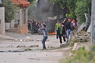
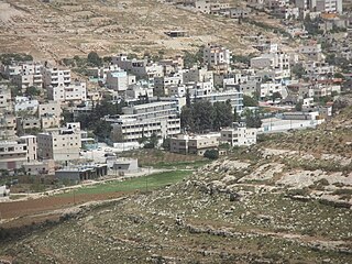
Dheisheh is a Palestinian refugee camp located just south of Bethlehem in the West Bank. Dheisheh was established in 1949 on 0.31 square kilometers of land leased from the Jordanian government. The camp was established as a temporary refuge for 3,400 Palestinians from 45 villages west of Jerusalem and Hebron who fled during the 1948 Arab–Israeli War. The camp had a population of 8,805 in 2017.

Husan is a Palestinian town located 9 km (5.6 mi) west of Bethlehem, in the Bethlehem Governorate. According to the Palestinian Central Bureau of Statistics, Husan had a population of 7,048 in 2017.
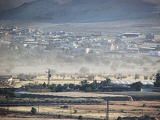
Al-Arroub is a Palestinian refugee camp located in the southern West Bank along the Hebron-Jerusalem road, in the Hebron Governorate of the State of Palestine. Al-Arroub is 15 kilometers south of Bethlehem, with a total land area of 240 dunums.
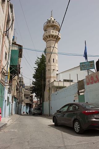
'Azza also known as Beit Jibrin Camp is a Palestinian refugee camp in the Bethlehem Governorate located within the city of Bethlehem. It is the smallest of the 59 refugee camps in the West Bank and the other Arab countries. It was established in 1950 in an area of 20 dunams and receives services from UNRWA workers based in nearby Aida camp, but inside the camp, there are no medical or educational services, so it was merged with the Aida camp to receive services.
Fasayil or Fasa'il is a Palestinian village in the northeastern West Bank, a part of the Jericho Governorate, located 14 kilometres (8.7 mi) northwest of Jericho and about 40 kilometres (25 mi) southeast of Nablus. The closest Palestinian locality is Duma to the west. The village is located 2 km south of the Israeli settlement of Petza'el. According to the 2017 census by the Palestinian Central Bureau of Statistics (PCBS), the village had a population of 1,637.
Khirbet al-Deir, or Khirbet ed-Deir, is a Palestinian village located 10 kilometres (6.2 mi) southwest of Bethlehem, and 15 kilometres (9.3 mi) northwest of Hebron. The town is in the Hebron Governorate of central West Bank. According to the 2017 Palestinian Central Bureau of Statistics (PCBS) Census, the village had a population of 358 people.

Za'atara is a Palestinian town located 11 km (6.8 mi) southeast of Bethlehem. The town is in the Bethlehem Governorate central West Bank. According to the Palestinian Central Bureau of Statistics, the town had a population of over 7,849 in 2017.
Fawwar is a Palestinian town and refugee camp in the Hebron Governorate, located six kilometers southwest of Hebron in the southern West Bank. According to the Palestinian Central Bureau of Statistics, the camp had a population of 7,641 in 2017.
'Arab al-Rashayida is a Palestinian village in the Bethlehem Governorate, central West Bank. According to the Palestinian Central Bureau of Statistics, the city had a population of 2,060 in 2017.
as-Sawahira ash Sharqiya or Al-Sawahreh al-Sharqiyeh is a Palestinian town in the Jerusalem Governorate, located 6 kilometers south-east of East Jerusalem in the West Bank. According to the Palestinian Central Bureau of Statistics (PCBS), as-Sawahira ash Sharqiya had a population of 6,204 inhabitants in 2017. as-Sawahira ash Sharqiya shares the facilities, particularly schools and health amenities of the villages of Jabal Mukaber and ash-Sheikh Sa'd. The healthcare facilities for as-Sawahira ash Sharqiya are designated as Ministry of Health level 2.

az-Za'ayyem is a Palestinian village in the Jerusalem Governorate, located 3 kilometers east of Jerusalem in the central West Bank. According to the Palestinian Central Bureau of Statistics, the village had a population of 6,270 in 2017. The healthcare facilities for az-Za'ayyem according to the Ministry of Health are obtained in East Jerusalem.
Shuyukh al-Arrub is a Palestinian village located eleven kilometers north-east of Hebron. The village is in the Hebron Governorate Southern West Bank. According to the Palestinian Central Bureau of Statistics, the village had a population of 1,958 inhabitants in 2017. The primary health care facilities for the village are designated by the Ministry of Health as level 2.
Wadi al-Arayis is a Palestinian village located ten kilometers east of Bethlehem.The village is in the Bethlehem Governorate Southern West Bank. According to the Palestinian Central Bureau of Statistics, the village had a population of 2,169 in mid-year 2006. The primary healthcare is obtained in al 'Ubeidiya where the Ministry of Heath have classified the care facilities as level 3.
Hindaza is a Palestinian village located six kilometers south-east of Bethlehem. The village is in the Bethlehem Governorate Southern West Bank. According to the Palestinian Central Bureau of Statistics, the village had a population of 7,517 in 2017. The primary healthcare is obtained in Za'atara where the Ministry of Heath have classified the care facilities as level 3.

Umm Salamuna is a Palestinian village located twelve kilometers South-west of Bethlehem. The village is in the Bethlehem Governorate in the southern West Bank. According to the Palestinian Central Bureau of Statistics, the village had a population of 1,188 in 2017. The primary healthcare is obtained in Beit Fajjar where the Ministry of Heath have classified the care facilities as level 3.
Ashawawra is a Palestinian village located twelve kilometers southeast of Bethlehem. The village is in the Bethlehem Governorate central West Bank.
Marah Rabah is a Palestinian village located twelve kilometers south of Bethlehem. The village is in the Bethlehem Governorate central West Bank. According to the Palestinian Central Bureau of Statistics, the town had a population of over 1,729 in 2017. The primary healthcare is obtained in Tuqu', where the Ministry of Health denotes the healthcare facilities as level 2.
Jannatah is a Palestinian town in the central West Bank 5 kilometers (3.1 mi) south of Bethlehem in the Bethlehem Governorate. Nearby villages include Hindaza in the north and Tuqu' to the south. It is situated 570 meters (1,870 ft) above sea level. The total land area is 11,901 dunams of which 319 constitute built-up area and 277 have been confiscated by the Israeli government for settlements and a military base. Much of the remainder is used for arable land.
Al-Maniya is a Palestinian village in the Bethlehem Governorate in the central West Bank, 8.6 km southeast of Bethlehem and just south of Tuqu'. It incorporates the nearby hamlet of Wadi Muhammad within its jurisdiction. Most of the village, including much of its built-up area, is in Area C, giving the Israeli military full control over the village. It had a population of 1,346 in the 2017 census by the Palestinian Central Bureau of Statistics.
Ammuriya is a Palestinian village in the Nablus Governorate of the State of Palestine in the northern West Bank, located south of Nablus. According to the Palestinian Central Bureau of Statistics (PCBS) census, Ammuriya had a population of 371 in 2017. There were 48 households and five business establishments in the village.

