Look up Kashmir in Wiktionary, the free dictionary.
Kashmir mainly refers to the northwestern region of the Indian subcontinent claimed by China, India, and Pakistan.
Contents
Kashmir may also refer to:
Kashmir mainly refers to the northwestern region of the Indian subcontinent claimed by China, India, and Pakistan.
Kashmir may also refer to:

Kashmir is the northernmost geographical region of the Indian subcontinent. Until the mid-19th century, the term "Kashmir" denoted only the Kashmir Valley between the Great Himalayas and the Pir Panjal Range. Today, the term encompasses a larger area that includes the India-administered territories of Jammu and Kashmir and Ladakh, the Pakistan-administered territories of Azad Kashmir and Gilgit-Baltistan, and the Chinese-administered territories of Aksai Chin and the Trans-Karakoram Tract.

The Srinagar District is an administrative district of Indian-administered Jammu and Kashmir in the disputed Kashmir region. It is one of the 20 districts of Jammu and Kashmir. Situated in the centre of the Kashmir Valley, it is the second-most populous district of the union territory after Jammu District as per the 2011 national census, and is home to the summer capital city of Srinagar. Likewise, the city of Srinagar also serves as the Srinagar District's headquarters.

Muzaffarabad is a city in Pakistani-administered Azad Kashmir in the disputed Kashmir region. It is the largest city and the capital of Azad Kashmir, which is a Pakistani-administered administrative territory.

Bhimber District is a district of Pakistan-administered Azad Kashmir in the disputed Kashmir region. It is the southernmost of the 10 districts of Pakistan's territory of Azad Kashmir. It has an area of 1,516 km², and the district headquarter is the town of Bhimber.

Kotli District is a district of Pakistan-administered Azad Kashmir in the Azad Kashmir region. It is one of the 10 districts of Pakistan's dependent territory of Azad Kashmir. It is bounded on the north by the Sudhanoti District and the Poonch District, on the north-east by the Poonch District of Indian-administered Jammu and Kashmir, on the south by the Mirpur and Bhimber districts, and on the west by the Rawalpindi District on Pakistan's Punjab Province. Kotli is the biggest district of Azad Kashmir by population and the second biggest by land area, after the Neelum District. The district headquarters is the city of Kotli. The main native languages are Pahari, and Gujari.

The Muzaffarabad District is a district of Pakistan-administered Azad Kashmir in the disputed Kashmir region. It is one of the 10 districts of this dependent territory. The district is located on the banks of the Jhelum and Neelum rivers and is very hilly. The total area of the Muzaffarabad District is 1,642 square kilometres (634 sq mi). The district is part of the Muzaffarabad Division, and the city of Muzaffarabad serves as the capital of Azad Kashmir. The district is bounded on the north-east by the Neelum District and the Kupwara District of Indian-administered Jammu and Kashmir region, on the south-east by the Hattian Bala District, on the south by the Bagh District, and on the west by the Mansehra and Abbottabad districts of Pakistan's Khyber Pakhtunkhwa Province.

Poonch District is a district of Pakistan-administered Azad Kashmir in the disputed Kashmir region. It is one of the 10 districts of this Pakistan-administered territory. It is bounded on the north by Bagh District, on the north-east by Haveli District, on the south-east by the Poonch District of Indian-administered Kashmir, on the south by Azad Kashmir's Sudhanoti and Kotli districts, and on the west by Rawalpindi District of Pakistan's Punjab Province. The Poonch District is part of the greater Kashmir dispute between India and Pakistan. The district headquarters is the city of Rawalakot. It is the third most populous district of Azad Kashmir.
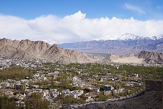
Leh district is a district in Indian-administered Ladakh in the disputed Kashmir-region. Ladakh is an Indian-administered union territory. With an area of 45,110 km2, it is the second largest district in the country, second only to Kutch. It is bounded on the north by Gilgit-Baltistan's Kharmang and Ghanche districts and Xinjiang's Kashgar Prefecture and Hotan Prefecture, to which it connects via the historic Karakoram Pass. Aksai Chin and Tibet are to the east, Kargil district to the west, and Lahul and Spiti to the south. The district headquarters is in Leh. It lies between 32 and 36 degree north latitude and 75 to 80 degree east longitude.
Jammudistrict is an administrative district of the Jammu division of Indian-administered Jammu and Kashmir in the disputed Kashmir region. It is the most populous district in the Jammu division.
Pulwama is a city and notified area council in the Pulwama district of Indian-administered Jammu and Kashmir in the disputed Kashmir region. It is located approximately 25 kilometres (16 mi) south of the summer capital of the state, Srinagar.

Chilas is a city in Pakistani-administered Gilgit–Baltistan in the disputed Kashmir region. It is the divisional capital of Diamer Division and is located on the Indus River. It is part of the Silk Road, connected by the Karakoram Highway and N-90 National Highway to Islamabad and Peshawar in the southwest, via Hazara and Malakand divisions of Khyber Pakhtunkhwa. To the north, Chilas connects to the cities of Tashkurgan and Kashgar in Xinjiang, China, via Gilgit, Aliabad, Sust, and the Khunjerab Pass.

Kupwara district is an administrative district of Indian-administered Jammu and Kashmir in the disputed Kashmir region. It is one of the 10 districts located in the Kashmir Valley Division of Indian administered Kashmir. The Pohru River and Mawar river are two main rivers in the district. Both of them meet Jhelum river in Baramulla district.

Neelum is a district of Pakistan-administered Azad Kashmir in the disputed Kashmir region. It is the northernmost of 10 districts located within the Pakistani-administered territory of Azad Kashmir. Taking up the larger part of the Neelum Valley, the district had a population of around 191,000 people. It was among the worst-hit areas of Pakistan during the 2005 Kashmir earthquake.

The Kashmir division is a revenue and administrative division of the Indian-administered Jammu and Kashmir in the disputed Kashmir region. It comprises the Kashmir Valley, bordering the Jammu Division to the south and Ladakh to the east. The Line of Control forms its boundary with the Pakistani-administered territories of Gilgit−Baltistan and Azad Jammu and Kashmir to the north and west and west, respectively.
Rondu District, also spelled Roundu District, is a district of Pakistan-administered Gilgit-Baltistan in the disputed Kashmir region. It is one of 14 districts of Gilgit-Balistan. The district encompasses the entire Roundu Valley, which is the fourth-largest valley in Gilgit-Baltistan, after the Skardu, Khaplu, and Shigar valleys. The Roundu valley lies in the western part of the Baltistan Division and forms the main trade and travel route between the Baltistan Division and the Gilgit Division. The Rondu District was carved out of Skardu District in 2019.
Shigar District is a district in Gilgit-Baltistan area of Pakistan in the disputed Kashmir region. It is home to the world's second highest peak, K2, also known as Chhogori and Mount Godwin-Austen. The district is bounded on the north by the Nagar District, the Hunza District, and the Kashgar Prefecture of China's Xinjiang Uyghur Autonomous Region, on the south-east by the Ghanche District, on the south-west by the Rondu and Skardu districts, and on the west by the Gilgit District. Shigar District was established in 2015, prior to which it had been part of the Skardu District.
Hunza District is a district of Pakistan-administered Gilgit-Baltistan in the disputed Kashmir region. It is one of the 14 districts of the Gilgit-Baltistan region. It was established in 2015 by the division of the Hunza–Nagar District in accordance with a government decision to establish more administrative units in Gilgit-Baltistan. The district headquarters is the town of Karimabad.
Baltistan Division is a first-order administrative division of Pakistan-administered Gilgit-Baltistan in the disputed Kashmir region. It overlaps with the historical Baltistan region.
Darel District is a district of Pakistan's Gilgit-Baltistan area in the disputed Kashmir region. It is lies south-west of Gilgit District. Its population lives mainly in the valley of the Darel River, a right tributary of the Indus River.

Ghizer District is a district of Pakistan-administered Gilgit-Baltistan region in the disputed Kashmir region. It is one of the 14 districts of Gilgit-Baltistan. The former Ghizer District that existed from 1974 to 2019 spanned the entire upper Gilgit River Valley. In 2019, the former district was divided into the Gupis-Yasin District in the west and the present, smaller Ghizer District in the east.