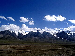
The Kunlun Mountains are one of the longest mountain chains in Asia, extending more than 3,000 kilometres (1,900 mi). In the broadest sense, the chain forms the northern edge of the Tibetan Plateau south of the Tarim Basin.

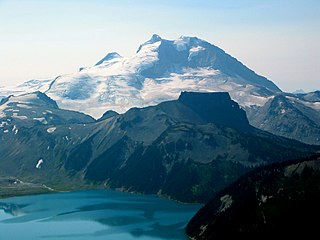
The Garibaldi Volcanic Belt is a northwest-southeast trending volcanic chain in the Pacific Ranges of the Coast Mountains that extends from Watts Point in the south to the Ha-Iltzuk Icefield in the north. This chain of volcanoes is located in southwestern British Columbia, Canada. It forms the northernmost segment of the Cascade Volcanic Arc, which includes Mount St. Helens and Mount Baker. Most volcanoes of the Garibaldi chain are dormant stratovolcanoes and subglacial volcanoes that have been eroded by glacial ice. Less common volcanic landforms include cinder cones, volcanic plugs, lava domes and calderas. These diverse formations were created by different styles of volcanic activity, including Peléan and Plinian eruptions.

Bazman is a stratovolcano in a remote desert region of Sistan and Baluchestan Province in south-eastern Iran. A 500-m-wide crater caps the summit of the dominantly andesitic-dacitic volcano, the flanks of which are covered by monogenetic centres especially to the northwest. Bazman is a geologically young volcano which was made in the Quaternary, with the oldest dated rocks being 11.7 million years old and the youngest 0.6 million years. Although no historic eruptions have been reported from Bazman, it does contain fumaroles. Thus Bazman may be regarded as dormant, rather than extinct. Its satellite cones have been the source of basaltic lava flows.

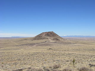
Sierra Grande is an extinct shield volcano in northeastern New Mexico that rises 2,200 feet above the surrounding plain. It is part of the inactive Raton-Clayton volcanic field.

Tokachi Volcanic Group is a volcanic group of mainly stratovolcanoes arrayed along a southwest-northeast axis in Hokkaidō, Japan.
Ruby Mountain, locally known as Old Volcano, is a cinder cone in Stikine Region, British Columbia, Canada, located 23 km northeast of Atlin and 6 km (4 mi) south of Mount Barham. A recent collapse on the volcano's eastern side created a large landslide which dissects this side of Ruby Mountain. The volcano is the largest feature within the Atlin Volcanic Field.
The Desolation Lava Field is a volcanic field associated with the Mount Edziza volcanic complex in British Columbia, Canada. It covers 150 km2 (58 sq mi) on the northern end of the Mount Edziza volcanic complex and is the largest area of the youngest lava flows. The longest lava flow from the field and the volcanic complex, is about 12 km (7.5 mi) long. Eve Cone, in the middle of the field, is one of the most symmetrical and best preserved cinder cones in Canada.

Volcanology of Canada includes lava flows, lava plateaus, lava domes, cinder cones, stratovolcanoes, shield volcanoes, submarine volcanoes, calderas, diatremes, and maars, along with examples of more less common volcanic forms such as tuyas and subglacial mounds. It has a very complex volcanological history spanning from the Precambrian eon at least 3.11 billion years ago when this part of the North American continent began to form.

The geology of the Pacific Northwest includes the composition, structure, physical properties and the processes that shape the Pacific Northwest region of the United States and Canada. The geology of the region is responsible for some of area's scenic beauty as well as some of its hazards, such as volcanoes, earthquakes, and landslides.
Albuquerque volcanic field is a monogenetic volcanic field in the Albuquerque Basin in New Mexico, United States. The Albuquerque volcanic field is made of monogenetic volcanoes that produced lava flows, cinder cones, and spatter cones. It is located about 11 km west-northwest of the city of Albuquerque, and is contained within the borders of Petroglyph National Monument. The oldest lava flows cover about 60 square km. The cones are aligned and possibly formed above two roughly north-south trending fissures. J cone is the highest feature. Its base is made of cinder, but the crater contains a lava dome that was cut by an explosive eruption. The Albuquerque volcanic field was active from 170,000 to 70,000 years ago.

The Wells Gray-Clearwater volcanic field, also called the Clearwater Cone Group, is a potentially active monogenetic volcanic field in east-central British Columbia, Canada, located approximately 130 km (81 mi) north of Kamloops. It is situated in the Cariboo Mountains of the Columbia Mountains and on the Quesnel and Shuswap Highlands. As a monogenetic volcanic field, it is a place with numerous small basaltic volcanoes and extensive lava flows.

The Volcano, also known as Lava Fork volcano, is a small cinder cone in the Boundary Ranges of the Coast Mountains in northwestern British Columbia, Canada. It is located approximately 60 km (40 mi) northwest of the small community of Stewart near the head of Lava Fork. With a summit elevation of 1,656 m (5,433 ft) and a topographic prominence of 311 m (1,020 ft), it rises above the surrounding rugged landscape on a remote mountain ridge that represents the northern flank of a glaciated U-shaped valley.

The volcanic history of the Northern Cordilleran Volcanic Province presents a record of volcanic activity in northwestern British Columbia, central Yukon and the U.S. state of easternmost Alaska. The volcanic activity lies in the northern part of the Western Cordillera of the Pacific Northwest region of North America. Extensional cracking of the North American Plate in this part of North America has existed for millions of years. Continuation of this continental rifting has fed scores of volcanoes throughout the Northern Cordilleran Volcanic Province over at least the past 20 million years and occasionally continued into geologically recent times.

The Satah Mountain volcanic field (SMVF) is an extensive north-south trending volcanic chain in the Central Interior of British Columbia that stretches south of the Itcha Range shield volcano to northeast of Nimpo Lake. The chain is located on the Chilcotin Plateau, a major subdivision of the Interior Plateau that includes other nearby volcanic features. It forms a segment of the east-west trending Anahim Volcanic Belt, whose volcanic activity ranges in age from Miocene-to-Holocene. Volcanic features in the Satah Mountain field include lava domes, cinder cones and lava flows. Its name originates from Satah Mountain, the highest volcano, located 35 km (22 mi) northeast of Nimpo Lake.
Vulcan, named after the Roman god of fire, is an inactive volcano on Albuquerque, New Mexico's West Mesa. It is the largest of the volcanoes in Albuquerque's Volcanic Field. Vulcan is a spatter cone, formed primarily by fire fountains that were active in the central vent and in smaller vents on flanks of the cone. These flank vents formed the arches and caves seen today. From a vantage point on top of the cone 600 feet above valley floor, the alignment of the 5-mile-long chain of vents is particularly noticeable. Fragmented cinder and spatter material and lava flows dip at angles as high as 55° away from the central vent on the eastern and southern side of Vulcan. The spatter material is thickest on the southeastern side of Vulcan, indicating that it was blown by the wind toward the south and east during the fountaining events. A solidified lava pond that consists of a massive gray basalt with weakly developed columnar jointing occupies the crater of Vulcan. Radial, sinuous lava tubes 8 to 20 inches across and 300 feet long are preserved on the northeast and northwest flanks of Vulcan.

The Andagua volcanic field is a volcanic field in southern Peru. Located between the Coropuna and Sabancaya volcanoes, it is formed from a number of lava domes and scoria cones that have generated lava flows. Activity ranges from the early Pleistocene until historical times.
Longgang is a volcanic field in Jilin Province, China. It is also known as Chingyu, Longwan Group or Lung-wan Group. This volcanic field contains over 164 individual centres in the form of crater lakes, maars and volcanic cones and covers a surface area of 1,700 square kilometres (660 sq mi). The field is forested and mostly undisturbed by human activities.

Pali-Aike volcanic field is a volcanic field in Argentina which straddles the border with Chile. It is part of a province of back-arc volcanoes in Patagonia, which formed from processes involving the collision of the Chile Rise with the Peru–Chile Trench. It lies farther east than the Austral Volcanic Zone, the volcanic arc which forms the Andean Volcanic Belt at this latitude.

Cima volcanic field is a volcanic field in San Bernardino County, California, close to the border with Nevada. The volcanic field covers a surface area of 600 square kilometres (230 sq mi) within the Mojave National Preserve west of the Cima Dome and consists of about 40 volcanic cones with about 60 lava flows. The volcanic cones range from simple cones over multi-cratered mountains to eroded hills, and lava flows are up to 9.1 kilometres (5.7 mi) long. At least one lava tube exists in the field and can be visited.