King George V Dock, Glasgow

Last updated

View of the docks at the River Clyde River Clyde Looking Towards King George V Dock - geograph.org.uk - 372544.jpg
View of the docks at the River Clyde

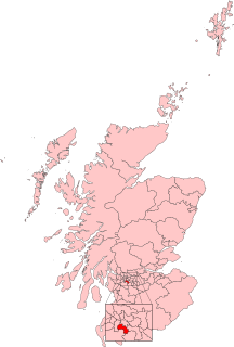
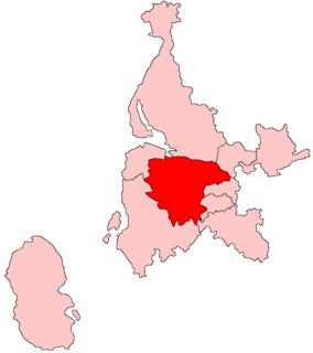
King George V Dock is a dock for ocean-going vessels operated by the Clyde Port Authority in the Shieldhall (Govan) area of Glasgow in the west central Lowlands of Scotland. It is located near Braehead in Renfrewshire and lies on the boundary between the council areas of Renfrewshire and the City of Glasgow.

Shieldhall district of Glasgow, Scotland

Shieldhall is a district in the Scottish city of Glasgow. It is situated directly south of the River Clyde and is part of the winder Govan area.

Govan district and former burgh in the City of Glasgow, Scotland

Govan is a district, parish, and former burgh now part of south-west City of Glasgow, Scotland. It is situated 2.5 miles (4.0 km) west of Glasgow city centre, on the south bank of the River Clyde, opposite the mouth of the River Kelvin and the district of Partick. Historically it was part of the County of Lanark.

Glasgow City and council area in Scotland

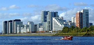
Glasgow is the most populous city in Scotland, and the third most populous city in the United Kingdom, as of the 2017 estimated city population of 621,020. Historically part of Lanarkshire, the city now forms the Glasgow City council area, one of the 32 council areas of Scotland; the local authority is Glasgow City Council. Glasgow is situated on the River Clyde in the country's West Central Lowlands. It is the fifth most visited city in the UK.

A large single basin with unrestricted entry, it opened in 1931 to accommodate the larger vessels then beginning to service the Clyde and was named after George V, the reigning monarch. [1] It is the largest dock on the Upper Clyde, as well as the only operational one within Glasgow's city boundary. The dock currently deals with dry bulk cargoes, including animal feeds, grains, chemicals and industrial equipment, and offers easy transfer of goods to the M8 motorway and the national rail network via the remaining stub of the Glasgow and Renfrew District Railway and the Inverclyde Line.

River Clyde river in Scotland

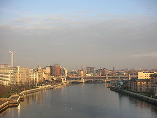
The River Clyde is a river that flows into the Firth of Clyde in Scotland. It is the eighth-longest river in the United Kingdom, and the second-longest in Scotland. Traveling through the major city of Glasgow, it was an important river for shipbuilding and trade in the British Empire. To the Romans, it was Clota, and in the early medieval Cumbric language, it was known as Clud or Clut, and was central to the Kingdom of Strathclyde.

M8 motorway (Scotland) motorway in Scotland

The M8 is the busiest motorway in Scotland and one of the busiest in the United Kingdom. It connects the country's two largest cities, Glasgow and Edinburgh, and serves other large communities including Airdrie, Coatbridge, Greenock, Livingston and Paisley. The motorway is 60 miles (97 km) long. A major construction project to build the final section between Newhouse and Baillieston was completed on 30 April 2017. The motorway has one service station, named Heart of Scotland Services, previously Harthill due to its proximity to the village.

The Glasgow and Renfrew District Railway was nominally owned by the Glasgow and Paisley Joint Railway. It was incorporated on 6 August 1897 and opened on 1 June 1903.

Related Research Articles

Inverclyde Council area of Scotland

Inverclyde ; is one of 32 council areas used for local government in Scotland. Together with the East Renfrewshire and Renfrewshire council areas, Inverclyde forms part of the historic county of Renfrewshire, which currently exists as a registration county and lieutenancy area - located in the west central Lowlands. It borders the North Ayrshire and Renfrewshire council areas, and is otherwise surrounded by the Firth of Clyde.

Renfrewshire Council area of Scotland

Renfrewshire is one of 32 council areas of Scotland.

Braehead commercial development located at the former site of Braehead Power Station in Renfrew

Braehead is a commercial development located at the former site of Braehead Power Station in Renfrew on the south bank of the River Clyde in Renfrewshire. It is particularly notable for its large shopping centre, arena and leisure facilities.

Port Glasgow Town in the Inverclyde council area of Scotland

Port Glasgow is the second largest town in the Inverclyde council area of Scotland. The population according to the 1991 census for Port Glasgow was 19,426 persons and in the 2001 census was 16,617 persons. The most recent census in 2011 states that the population has declined to 15,414. It is located immediately to the east of Greenock and was previously a burgh in the former county of Renfrew.

Strathclyde former local government region of Scotland

Strathclyde was one of nine former local government regions of Scotland created in 1975 by the Local Government (Scotland) Act 1973 and abolished in 1996 by the Local Government etc. (Scotland) Act 1994. The Strathclyde region had 19 districts.

Eastwood, Strathclyde human settlement in United Kingdom

Eastwood was a local government district in the Strathclyde region of Scotland from 1975 to 1996, lying south-west of the City of Glasgow.

Netherlee human settlement in the United Kingdom

Netherlee is a suburban residential area in East Renfrewshire, Scotland. It is situated on the west bank of the White Cart Water about 4 miles south of Glasgow city centre. Part of the Greater Glasgow conurbation, it is contiguous with the city, and is on the border between Glasgow and East Renfrewshire, on the East Renfrewshire side. It is therefore classified as a separate census locality from Glasgow. As of 2012, Netherlee has a population of 4,550.

Greater Glasgow human settlement in United Kingdom

Greater Glasgow is an urban settlement in Scotland consisting of all localities which are physically attached to the city of Glasgow, forming with it a single contiguous urban area. It does not relate to municipal government boundaries and its territorial extent is defined by the General Register Office for Scotland, which determines settlements in Scotland for census and statistical purposes. Greater Glasgow had a population of 1,199,629 at the time of the 2001 UK Census making it the largest urban area in Scotland and the fifth-largest in the United Kingdom.

Glasgow South (UK Parliament constituency) Parliamentary constituency in the United Kingdom, 2005 onwards

Glasgow South is a burgh constituency of the House of Commons of the Parliament of the United Kingdom (Westminster). It elects one Member of Parliament (MP) by the first past the post system of election.

River Kelvin river in Scotland

The River Kelvin is a tributary of the River Clyde in northern and northeastern Glasgow, Scotland. It rises on the moor south east of the village of Banton, east of Kilsyth. At almost 22 miles (35 km) long, it initially flows south to Dullatur Bog where it falls into a man made trench and takes a ninety degree turn flowing west through Strathkelvin and along the northern boundary of the bog parallel with the Forth and Clyde Canal.

Penilee

Penilee is a small housing scheme and suburb on the southwestern edge of Glasgow, Scotland. The area is bounded to its east by the Glasgow suburbs of Cardonald and Hillington, and to the west by the Renfrewshire border and the farms of North and South Arkleston. The district's southern boundary forms Glasgow's border with the Renfrewshire settlement of Ralston.

Glasgow Harbour urban development at Partick in the city of Glasgow, Scotland

Glasgow Harbour is an urban regeneration scheme at Partick in the West End of the city of Glasgow, Scotland.

Renfrewshire (historic) lieutenancy area of Scotland

Renfrewshire or the County of Renfrew is a historic county, registration county and lieutenancy area in the west central Lowlands of Scotland. It contains the local government council areas of Inverclyde, Renfrewshire and East Renfrewshire and is occasionally named Greater Renfrewshire to distinguish the county from the modern council area.

Renfrew Ferry

The Renfrew Ferry is a passenger ferry service linking the north and south banks of the River Clyde in Scotland. The service, operated by Clydelink without subsidy, crosses between Renfrew and Yoker, close to Glasgow City Centre and is the last Clyde crossing this far upstream.

West Renfrewshire (Scottish Parliament constituency)

West Renfrewshire was a constituency of the Scottish Parliament (Holyrood). It elected one Member of the Scottish Parliament (MSP) by the first past the post method of election. Also, however, it is one of nine constituencies in the West of Scotland electoral region, which elected seven additional members, in addition to nine constituency MSPs, to produce a form of proportional representation for the region as a whole.

Strathgryffe

Strathgryffe or Gryffe Valley is a strath centred on the River Gryffe in the west central Lowlands of Scotland. The River Gryffe passes through the council areas of Inverclyde and Renfrewshire, rising in Kilmacolm and joining the Black Cart Water between Houston and Inchinnan.

Renfrew town in Renfrewshire, Scotland

Renfrew is a town 6 miles (10 km) west of Glasgow in the west central Lowlands of Scotland. It is the historic county town of Renfrewshire. Called the "Cradle of the Royal Stewarts" for its early link with Scotland's former royal house, Renfrew gained royal burgh status in 1397.

George V Bridge, Glasgow road bridge in Glasgow, Scotland

George V Bridge is a three-arched road bridge over the River Clyde in the city centre of Glasgow, Scotland, named after King George V.

New River Clyde bridge

The New River Clyde bridge is a proposed construction as part of the ongoing regeneration of the Clyde waterfront area, in Scotland. If built, it will be the first new vehicle crossing point on the Clyde since the Clyde Arc bridge was built in 2006.

References

  1. Williamson, Elizabeth; Riches, Anne; Higgs, Malcolm (2005). The Buildings of Scotland: Glasgow. New Haven, Conn. [u.a.]: Yale Univ. Press. p. 595. ISBN   978-0-300-09674-3.

Coordinates: 55°52′08″N4°21′09″W / 55.86888°N 4.35256°W / 55.86888; -4.35256

Geographic coordinate system Coordinate system

A geographic coordinate system is a coordinate system that enables every location on Earth to be specified by a set of numbers, letters or symbols. The coordinates are often chosen such that one of the numbers represents a vertical position and two or three of the numbers represent a horizontal position; alternatively, a geographic position may be expressed in a combined three-dimensional Cartesian vector. A common choice of coordinates is latitude, longitude and elevation. To specify a location on a plane requires a map projection.