

King James's and Landport Gates are two English Heritage gateways in Portsmouth, Hampshire, England.
King James's and Landport Gates are two English Heritage gateways in Portsmouth, Hampshire, England.
Earthen ramparts protecting the land side of the port containing munitions, international goods storage, warehouses, shops and homes were constructed in the 14th century which were strengthened by order of Henry VIII in the 16th. [1] [2]
Four ornate gateways were originally access points to Portsmouth through the town walls. The majority of the town walls were demolished in 1860. [1] [2]
50°47′42.32″N1°5′55.30″W / 50.7950889°N 1.0986944°W
King James's Gate was built in 1687, probably as a reconstruction of the older Point gate on the same site, to control access to Portsmouth from The Point. [3] When the town walls were demolished the gate was moved to a pavement of St. Michaels Road. At a later, unknown, date it was moved again and is now roughly 0.5 miles (0.80 km) from its original position, forming part of the boundary of United Services Ground in Burnaby Road. During the moves, much of the original ornate stonework was purposefully sold or lost. [4]
50°47′37.05″N1°6′0.32″W / 50.7936250°N 1.1000889°W
Landport Gate was built in 1760 as a new main entry point to Portsmouth from the Dockyard and growing community on the Common. It replaced the original main point of access at the end of the High Street. Unlike the majority of Portsmouth's defences, the gate is still in its original position. [5]

Portsmouth is a port city primarily built on Portsea Island in the county of Hampshire, South East England. It is also known colloquially as Pompey, a nickname shared with HMNB Portsmouth and the Portsmouth Football Club. It is the United Kingdom's only island city. Portsmouth is situated 70 miles (110 km) south-west of London and 19 miles (31 km) south-east of Southampton. Portsmouth's population was recorded as 205,100 in the 2011 UK Census. The city forms part of the South Hampshire conurbation.

Woolwich Dockyard was an English naval dockyard along the river Thames at Woolwich in north-west Kent, where many ships were built from the early 16th century until the late 19th century. William Camden called it 'the Mother Dock of all England'. By virtue of the size and quantity of vessels built there, Woolwich Dockyard is described as having been 'among the most important shipyards of seventeenth-century Europe'. During the Age of Sail, the yard continued to be used for shipbuilding and repair work more or less consistently; in the 1830s a specialist factory within the dockyard oversaw the introduction of steam power for ships of the Royal Navy. At its largest extent it filled a 56-acre site north of Woolwich Church Street, between Warspite Road and New Ferry Approach; 19th-century naval vessels were fast outgrowing the yard, however, and it eventually closed in 1869. The former dockyard area is now partly residential, partly industrial, with remnants of its historic past having been restored.

The fortifications of Portsmouth are extensive due to its strategic position on the English Channel and role as home to the Royal Navy. For this reason, Portsmouth was, by the 19th century, one of the most fortified cities in the world. The fortifications have evolved over the centuries in response to changes in tactics and technology and the area defended has increased. While the first defences focused on Portsmouth harbour, in step with the fortifications of Gosport, later defensive structures protected the whole of Portsea Island and an increasing distance inland. At the same time, the fortifications of Portsmouth and Gosport became part of the wider fortifications of the Solent. Old Portsmouth, on the southwest corner of Portsea Island, has been walled for much of its history.

The Hilsea Lines are a line of 18th- and 19th-century fortifications built at Hilsea to protect the northern approach to Portsea Island, an island off the southern coast of England which forms the majority of the city of Portsmouth and its key naval base. They are now used as a greenspace and leisure area, also known locally as Foxes Forest.

Portsea Island is a flat, low-lying island measuring 24.5 square kilometres in area, just off the southern coast of England. The island is located within the traditional and ceremonial county of Hampshire and contains the majority of the city of Portsmouth.

Her Majesty's Naval Base, Portsmouth is one of three operating bases in the United Kingdom for the Royal Navy. Portsmouth Naval Base is part of the city of Portsmouth; it is located on the eastern shore of Portsmouth Harbour, north of the Solent and the Isle of Wight. Until the early 1970s, it was officially known as Portsmouth Royal Dockyard ; thereafter the term 'Naval Base' gained currency, acknowledging a greater focus on personnel and support elements alongside the traditional emphasis on building, repairing and maintaining ships. In 1984 Portsmouth's Royal Dockyard function was downgraded and it was formally renamed the 'Fleet Maintenance and Repair Organisation' (FMRO). The FMRO was privatized in 1998. Around the year 2000, the designation HMS Nelson was extended to cover the entire base.

Priddy's Hard is an area of Gosport, in Hampshire, England now being developed for housing with part of the site retained as a museum. However, for some two hundred years it was a restricted-access site; first becoming a fort and then an armaments depot for Royal Navy and British Army weapons, explosives and other stores.
The Royal William Victualling Yard in Stonehouse, a suburb of Plymouth, England, was the major victualling depot of the Royal Navy and an important adjunct of Devonport Dockyard. It was designed by the architect Sir John Rennie and was named after King William IV. It was built between 1826 and 1835 and occupies a site of approximately 16 acres (65,000 m2) being half of Western Kings, north of Devil's Point.

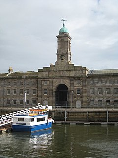
Portsmouth Point, or "Spice Island", is part of Old Portsmouth in Portsmouth, Hampshire, on the southern coast of England. The name Spice Island comes from the area's seedy reputation, as it was known as the "Spice of Life".. Men were easily found and press-ganged into Nelson's navy from Portsmouth Point due to its hostelries and for being where prostitutes plied their trade. The area forms the eastern side of the narrow entrance to Portsmouth Harbour, facing Gosport on the western side.

Landport is a district located on Portsea Island and is a central part of the city of Portsmouth, England. The district is centred around Commercial Road and encompasses the Guildhall, Civic Centre, Portsmouth and Southsea Station and Commercial Road central shopping area. The district of Portsea lies to the West; Old Portsmouth, Somers Town and Southsea are to the south; Fratton lies to the East and the Kingston Crescent area to the north.
Portsmouth is an island port city situated on Portsea Island in the county of Hampshire, England. Its history has been influenced by its association with the sea, and its proximity to London, and mainland Europe.

Her Majesty's Naval Base, Devonport is one of three operating bases in the United Kingdom for the Royal Navy and is the sole nuclear repair and refuelling facility for the Royal Navy. The largest naval base in Western Europe, HMNB Devonport is located in Devonport, in the west of the city of Plymouth, England.

Sheerness Dockyard also known as the Sheerness Station was a Royal Navy Dockyard located on the Sheerness peninsula, at the mouth of the River Medway in Kent. It was opened in the 1660s and closed in 1960.

There have been several town walls around Edinburgh, Scotland, since the 12th century. Some form of wall probably existed from the foundation of the royal burgh in around 1125, though the first building is recorded in the mid-15th century, when the King's Wall was constructed. In the 16th century the more extensive Flodden Wall was erected, following the Scots' defeat at the Battle of Flodden in 1513. This was extended by the Telfer Wall in the early 17th century. The walls had a number of gates, known as ports, the most important being the Netherbow Port, which stood halfway down the Royal Mile. This gave access from the Canongate which was, at that time, a separate burgh.

Southampton Castle was located in the town of Southampton in Hampshire, England. Constructed after the Norman conquest of England, it was located in the north-west corner of the town overlooking the River Test, initially as a wooden motte and bailey design. By the late 12th century the royal castle had been largely converted to stone, playing an important part in the wine trade conducted through the Southampton docks. By the end of the 13th century the castle was in decline, but the threat of French raids in the 1370s led Richard II to undertake extensive rebuilding. The result was a powerfully defended castle, one of the first in England to be equipped with cannon. The castle declined again in the 16th century and was sold off to property speculators in 1618. After being used for various purposes, including the construction of a Gothic mansion in the early 19th century, the site was flattened and largely redeveloped. Only a few elements of the castle still remain visible in Southampton.

Caernarfon's town walls are a medieval defensive structure around the town of Caernarfon in North Wales. The walls were constructed between 1283 and 1292 after the foundation of Caernarfon by Edward I, alongside the adjacent castle. The walls are 734 m (2,408 ft) long and include eight towers and two medieval gatehouses. The project was completed using large numbers of labourers brought in from England; the cost of building the walls came to around £3,500, a large sum for the period. The walls were significantly damaged during the rebellion of Madog ap Llywelyn in 1294, and had to be repaired at considerable expense. Political changes in the 16th century reduced the need to maintain such defences around the town. Today the walls form part of the UNESCO world heritage site administered by Cadw. Archaeologists Oliver Creighton and Robert Higham describe the defences as "a remarkably intact walled circuit".
Coventry's city walls are a sequence of defensive structures built around the city of Coventry in England.

Southampton's town walls are a sequence of defensive structures built around the town in southern England. Although earlier Roman and Anglo-Saxon settlements around Southampton had been fortified with walls or ditches, the later walls originate with the move of the town to the current site in the 10th century. This new town was defended by banks, ditches and the natural curve of the river and coastline. The Normans built a castle in Southampton but made no attempts to improve the wider defences of the town until the early 13th century, when Southampton's growing prosperity as a trading centre and conflict with France encouraged the construction of a number of gatehouses and stone walls to the north and east sides of the settlement.
Landport is a district located near the centre of Portsea Island and is part of the city of Portsmouth, England.
Royal Clarence Yard in Gosport, Hampshire, England was established in 1828 as one of the Royal Navy's two principal, purpose built, provincial victualling establishments. It was designed by George Ledwell Taylor, Civil Architect to the Navy Board and named after the then Duke of Clarence. The new victualling yard was developed on approximately 20 hectares of land, some of which was already in use as a brewing establishment at Weevil on the west shore of Portsmouth Harbour, to the north of Gosport.