Kinyinya | |
|---|---|
| Coordinates: 3°39′S30°21′E / 3.650°S 30.350°E | |
| Country | |
Kinyinya is a city in eastern Burundi, close to the border with Tanzania. It is located southwest of Gisuru and northeast of Mount Kikizi.
Kinyinya | |
|---|---|
| Coordinates: 3°39′S30°21′E / 3.650°S 30.350°E | |
| Country | |
Kinyinya is a city in eastern Burundi, close to the border with Tanzania. It is located southwest of Gisuru and northeast of Mount Kikizi.
The Dennistoun Glacier is a glacier, 50 nautical miles long, draining the northern slopes of Mount Black Prince, Mount Royalist and Mount Adam in the Admiralty Mountains of Victoria Land, Antarctica. It flows northwest between the Lyttelton Range and Dunedin Range, turning east on rounding the latter range to enter the sea south of Cape Scott.

JAWA is a motorcycle and moped manufacturer founded in Prague, Czechoslovakia, in 1929 by František Janeček, who bought the motorcycle division of Wanderer. The name JAWA was established by concatenating the first letters of Janeček and Wanderer. In the past, especially in the 1950s, JAWA was one of the top motorcycle manufacturers and exported its 350 model to over 120 countries. The best known model was the 350 Pérák, and in the 1970s the 350 Californian. It appeared in typical black and red coloring from the US to New Zealand. After 1990 a significant loss of production occurred. A successor company was formed in 1997 in Týnec nad Sázavou, continuing the name as JAWA Moto.

The Molucca Sea is located in the western Pacific Ocean, around the vicinity of Indonesia, specifically bordered by the Indonesian Islands of Celebes (Sulawesi) to the west, Halmahera to the east, and the Sula Islands to the south. The Molucca Sea has a total surface area of 77,000 square miles. The Molucca Sea is rich in coral and has many diving sites due to the deepness of its waters. The deepness of the water explains the reasoning behind dividing the sea into three zones, which functions to transport water from the Pacific Ocean to the shallower seas surrounding it. The deepest hollow in the Molucca Sea is the 15,780-foot (4,810-meter) Batjan basin. This region is known for its periodic experiences of earthquakes, which stems from the sea itself being a micro plate, in which the Molucca Sea is being subducted in two opposite directions: one in the direction of the Eurasian Plate to the west and the other in the direction of the Philippine Sea Plate to the east.

Panevėžys District Municipality is one of 60 municipalities in Lithuania.
Weida-Land is a Verbandsgemeinde in the Saalekreis district, in Saxony-Anhalt, Germany. It is situated between Querfurt and Eisleben. Before 1 January 2010, it was a Verwaltungsgemeinschaft. The seat of the Verbandsgemeinde is in Nemsdorf-Göhrendorf.

Rudná is a village and municipality in the Rožňava District in the Košice Region of middle-eastern Slovakia.

KORA-FM is a long-running radio station in Bryan, Texas currently owned by Brazos Valley Communications, LLC. Its format is Country, with emphasis on Texas artists and groups. Its Program Director is Rob Edwards. The station's studios and transmitter are located in Bryan.
Novosilski Bay extends its indention into the southern coastline of South Georgia, lying just south of Mount Fraser. It spans a width of 2 miles (3.2 km). This bay was first encountered by a Russian expedition led by Bellingshausen in 1819. It was named in honor of Lieutenant Pavel M. Novosilskiy, a member of the Mirny vessel that sailed alongside Bellingshausen's flagship, the Vostok, during the inaugural Russian Antarctic Expedition from 1819 to 1821.

Acacoyagua Municipality is a municipality in the Mexican state of Chiapas in southern Mexico. As of 2020, the municipality had a total population of 17,994, up from 14,189 as of 2005.
Royal Enfield is an Indian multinational motorcycle manufacturing company, headquartered in Chennai. The Royal Enfield brand, including its original English heritage, is the oldest global motorcycle brand in continuous production. The company operates manufacturing plants in Chennai in India.
Qaraçay is a village and municipality in the Quba Rayon of Azerbaijan. It has a population of 1,245.
The Manawapou River is a river of the Taranaki Region of New Zealand's North Island. It flows southwest, from its origins in rough hill country to the northeast of Hāwera, to reach the South Taranaki Bight between Hāwera and Patea.

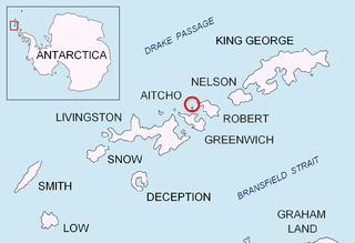
Emeline Island is a conspicuous rocky island rising to over 100 m (328 ft) in the Aitcho group on the west side of English Strait in the South Shetland Islands, Antarctica. The island extends 550 by 320 m with a surface area of 18 hectares. The area was visited by early 19th century seal hunters.
Sõõrike is a village in Põhja-Pärnumaa Parish, Pärnu County in southwestern Estonia.
Žutice is a village in the municipality of Raška, Serbia. According to the 2002 census, the village has a population of 224 people.
Damocles Point is a headland on the east coast of Alexander Island, 3 nautical miles (6 km) east-southeast of the south summit of Mount Tyrrell. A small rock exposure near sea level is surmounted by a 60 metres (200 ft) ice cliff. The headland is adjacent to George VI Sound and is facing towards the Rymill Coast in Palmer Land. It was first photographed from the air in 1937 by the British Graham Land Expedition under Rymill. It was surveyed in 1948 by the Falkland Islands Dependencies Survey, and so named by them because the ice cliff overhanging the spot where geological specimens were collected seemed like the sword of Damocles.
Fitzpatrick, M., Parkinson, T., & Ray, N. (2006) East Africa. Footscray, VIC: Lonely Planet.
3°39′S30°21′E / 3.650°S 30.350°E