Geography
| | This section is empty. You can help by adding to it. (July 2010) |
Kootenay was a provincial electoral district in the province of British Columbia, Canada, from 1871 to 1890. It was originally a two-member riding until the 1875 election; from 1878, it was a one-member seat until its partition for the 1890 election into East Kootenay and West Kootenay. For the 1966 election, the riding-name was re-established, but the area described was only the East Kootenay and included none of the West Kootenay.
| Population | |
| Population Change, | % |
| Area (km²) | |
| Pop. Density (people per km²) |
| | This section is empty. You can help by adding to it. (July 2010) |
| | This section is empty. You can help by adding to it. (July 2010) |
| | This section is empty. You can help by adding to it. (July 2010) |
| Party | Candidate | Votes | % | ± | Expenditures | |
|---|---|---|---|---|---|---|
| Independent | John Andrew Mara | 17 | 43.59% | unknown | ||
| Independent | William Cosgrove Milby | 9 | 23.08% | unknown | ||
| Independent | Charles Todd | 13 | 13.33% | unknown | ||
| Total valid votes | 39 | 100.00% | ||||
| 1875 British Columbia general election | ||||||||
|---|---|---|---|---|---|---|---|---|
| Party | Candidate | Votes | % | Elected | ||||
| Reform caucus | Robert Leslie Thomas Galbraith | 16 | 25.40% | |||||
| Reform caucus | Charles Gallagher | 16 | 25.40% | |||||
| Government | William Cosgrove Milby | 15 | 23.80% | |||||
| Reform caucus | Arthur Wellesley Vowell | 48 | 23.88% | |||||
| Total valid votes | 63 | |||||||
| To break a three-way tie, the Returning Officer cast the deciding votes for Gallagher and Vowell (Victoria Colonist 24 October 1875) | ||||||||
| 1878 British Columbia general election | ||||||||
|---|---|---|---|---|---|---|---|---|
| Party | Candidate | Votes | Elected | |||||
| Opposition (?) | Robert Leslie Thomas Galbraith | Accl. | ||||||
| Opposition (?) | Charles Gallagher | Accl. | ||||||
| Total valid votes | 187 | |||||||
| Party | Candidate | Votes | % | ± | Expenditures | |
|---|---|---|---|---|---|---|
| Government | Robert Leslie Thomas Galbraith | Accl. | --% | – | unknown | |
| Total valid votes | -- | --% | ||||
| Total rejected ballots | ||||||
| Turnout | ||||||
| 1Seat reduced to one member from two. | ||||||
| Party | Candidate | Votes | % | ± | Expenditures | |
|---|---|---|---|---|---|---|
| Government | James Baker | 111 | 60.00% | – | unknown | |
| Opposition | William M. Brown | 74 | 40.00% | – | unknown | |
| Total valid votes | 185 | 100.00% | ||||
| Total rejected ballots | ||||||
| Turnout | % | |||||
The riding was partitioned for the 1894 election.
The riding-name was re-established in time for the 1966 election, but covered only the East Kootenay region rather than the entire Kootenays as had been the case in its first incarnation.
| Party | Candidate | Votes | % | ± | Expenditures | |
|---|---|---|---|---|---|---|
| Social Credit | Robert Owen Jones | 3,070 | 34.89% | – | unknown | |
| Liberal | Henry Cartmell (Harry) McKay | 2,123 | 24.13% | unknown | ||
| NDP | Leo Thomas Nimsick | 3,605 | 40.98% | unknown | ||
| Total valid votes | 8.798 | 100.00% | ||||
| Total rejected ballots | 54 | |||||
| Turnout | % | |||||
| Party | Candidate | Votes | % | ± | Expenditures | |
|---|---|---|---|---|---|---|
| Social Credit | J. Harry Broadhurst | 4,267 | 38.26% | – | unknown | |
| Liberal | Henry Nelson | 2,604 | 23.35% | unknown | ||
| NDP | Leo Thomas Nimsick | 4,282 | 38.39% | unknown | ||
| Total valid votes | 11,153 | 100.00% | ||||
| Total rejected ballots | 173 | |||||
| Turnout | % | |||||
| Party | Candidate | Votes | % | ± | Expenditures | |
|---|---|---|---|---|---|---|
| Liberal | Harry Edwards Caldwell | 1,872 | 13.64% | unknown | ||
| NDP | Leo Thomas Nimsick | 6,065 | 44.20% | unknown | ||
| Social Credit | Ronald Powell | 1,615 | 11.77% | – | unknown | |
| PC | David John Reeves | 4,169 | 30.38% | unknown | ||
| Total valid votes | 13,721 | 100.00% | ||||
| Total rejected ballots | 180 | |||||
| Turnout | % | |||||
| Party | Candidate | Votes | % | ± | Expenditures | |
|---|---|---|---|---|---|---|
| Social Credit | George Wayne Haddad | 7,915 | 52.29% | – | unknown | |
| NDP | Leo Thomas Nimsick | 7,223 | 47.71% | unknown | ||
| Total valid votes | 15,138 | 100.00% | ||||
| Total rejected ballots | 220 | |||||
| Turnout | % | |||||
| Party | Candidate | Votes | % | ± | Expenditures | |
|---|---|---|---|---|---|---|
| PC | Roy Wilburn Paul | 975 | 7.80% | unknown | ||
| Social Credit | Terence Patrick Segarty | 6,167 | 49.37% | – | unknown | |
| NDP | Douglas Wayne Right | 5,350 | 42.83% | unknown | ||
| Total valid votes | 12,492 | 100.00% | ||||
| Total rejected ballots | 102 | |||||
| Turnout | % | |||||
| Party | Candidate | Votes | % | ± | Expenditures | |
|---|---|---|---|---|---|---|
| NDP | Harry Edwin Mathias | 8,245 | 47.36% | unknown | ||
| Liberal | Kory Palmer | 374 | 1.99% | unknown | ||
| Social Credit | Terence Patrick Segarty | 8,819 | 50.65% | – | unknown | |
| Total valid votes | 17,411 | 100.00% | ||||
| Total rejected ballots | 208 | |||||
| Turnout | % | |||||
| Party | Candidate | Votes | % | ± | Expenditures | |
|---|---|---|---|---|---|---|
| NDP | Kathleen Anne Edwards | 8,000 | 47.94% | unknown | ||
| Liberal | Paul R. Kershaw | 539 | 3.23% | unknown | ||
| Social Credit | Terence Patrick Segarty | 7,649 | 45.84% | – | unknown | |
| Progressive Conservative | James G. Smith | 499 | 2.99% | unknown | ||
| Total valid votes | 16,687 | 100.00% | ||||
| Total rejected ballots | 271 | |||||
| Turnout | % | |||||
Cariboo was a federal electoral district in British Columbia, Canada, that was represented in the House of Commons of Canada from 1871 to 1892.
Yale was a federal electoral district in British Columbia, Canada, that was represented in the House of Commons of Canada from 1872 to 1892 and from 1917 to 1953.
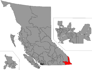
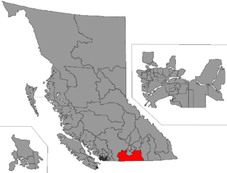
Kootenay East is a provincial electoral district for the Legislative Assembly of British Columbia, Canada. It was created before the 1966 election by the merger of Cranbrook and Fernie ridings, and despite its long period under the "Kootenay" moniker, never extended to cover more than a fraction of the whole "Kootenay" region.
The Lillooet electoral district was a riding in the Canadian province of British Columbia, centred on the town of the same name and with various boundaries. Originally with two members, the constituency was split into Lillooet West and Lillooet East in the 1894, 1898, and 1900 elections, with Lillooet West being recomprised as one riding in the 1903 election.
Yale was a provincial electoral district in British Columbia, Canada from the province's joining Confederation in 1871. It was a 3-member constituency and retained the name Yale until the 1894 election, at which time it was split into three ridings, Yale-East, Yale-North and Yale-West; other ridings in the southeast of the province had previously been split off, e.g., Fernie, Ymir, Grand Forks, which were later emerged or rearranged into the various Kootenay and Okanagan ridings. In 1903 the name Yale was revived, this time as a one-member riding only, the new riding largely based upon Yale-West. Its last appearance on the hustings was 1963. In 1966, it was amalgamated into the new riding of Yale-Lillooet, which was extant until 2009, when most of its core area was made part of the new Fraser-Nicola riding.
West Kootenay South was an electoral district in the Canadian province of British Columbia in the 1894 election only. Its official name was "West Kootenay ". It was formed from the division of the older Kootenay riding, one of the province's first twelve constituencies, which for the 1890 election was redistributed into:
West Kootenay North was an electoral district in the Canadian province of British Columbia in the 1894 election only. Its official name was "West Kootenay. It was formed from a partition the West Kootenay riding that also created West Kootenay.
East Kootenay North was an electoral district in the Canadian province of British Columbia in the 1898 and 1900 elections only. Its official name was East Kootenay (North Riding). It was created by a partition of the old East Kootenay riding which also created its sibling, East Kootenay (south riding). Successor ridings in the East Kootenay region were Fernie, Cranbrook and Columbia.
East Kootenay South was an electoral district in the Canadian province of British Columbia in the 1898 and 1900 elections. Its official name was East Kootenay (South Riding). It was created by the partition of the old East Kootenay riding which also created its sibling, East Kootenay (North Riding). Successor ridings in the East Kootenay region were Cranbrook, Fernie, and Columbia.
New Westminster was the name, or part of the name, of several Canadian federal and provincial electoral districts. All provincial and federal ridings in the area of the Lower Mainland were part of the original New Westminster ridings. "Off-spring" ridings are indicated accordingly.
West Kootenay was a provincial electoral district in the Canadian province of British Columbia. It was formed along with East Kootenay from a redistribution of the old Kootenay riding, which was one of the province's original twelve.
Greenwood was the name of a provincial electoral district in the Canadian province of British Columbia. It was located in there Boundary Country west of Grand Forks around the city of Greenwood. It first appeared on the hustings in the large redistribution prior to the 1903 election. For the 1924 election it was merged with the Grand Forks riding to form Grand Forks-Greenwood.
Boundary-Similkameen is a provincial riding formed in 2008. It includes the populations of Penticton-Okanagan Valley, West Kootenay-Boundary and Yale-Lillooet. The riding's name corresponds to that of a former riding in the same area, with similar but not identical boundaries.
Columbia was a provincial electoral district in the Canadian province of British Columbia. It made its first appearance on the hustings in the election of 1903. It lasted until the 1928 election, when it was merged into Columbia-Revelstoke for the 1933 election. Following the election the new Pattullo government moved to reestablish Columbia as a separate riding, and former MLA Thomas King was elected by acclamation in a 1934 by election.
Kaslo-Slocan was the name of a provincial electoral district in the Canadian province of British Columbia centred on the town of Kaslo on Kootenay Lake as well as the mining towns of the "Silvery Slocan". The riding first appeared in the 1924 election as the result of a merger of the former ridings of Kaslo and Slocan, and lasted until the 1963 election.
The 1894 British Columbia general election was held in 1894. The number of members remained at 33 with the number of ridings increased to 26 as a result of the partition of the Yale and Westminster ridings.
The Boundary Country is a historical designation for a district in southern British Columbia lying, as its name suggests, along the boundary between Canada and the United States. It lies to the east of the southern Okanagan Valley and to the west of the West Kootenay. It is often included in descriptions of both of those regions but historically has been considered a separate region. Originally inclusive of the South Okanagan towns of Osoyoos and Oliver, today the term continues in use to refer to the valleys of the Kettle, West Kettle, and Granby Rivers and of Boundary and Rock Creeks and that of Christina Lake and of their various tributaries, all draining the south slope of the Monashee Mountains The term Boundary District as well as the term Boundary Country can both refer to the local mining division of the British Columbia Ministry of Mines, Energy and Petroleum Resources.
East Kootenay was a provincial electoral district in use in British Columbia from 1890 to 1898. That riding's predecessor was the original Kootenay riding, and its successors were East Kootenay South and East Kootenay North.