An endorheic basin is a limited drainage basin that normally retains water and allows no outflow to other external bodies of water, such as rivers or oceans, but converges instead into lakes or swamps, permanent or seasonal, that equilibrate through evaporation. Such a basin may also be referred to as a closed or terminal basin or as an internal drainage system or interior drainage basin.
In geology, a chott or shott is a salt lake in Africa's Maghreb that stays dry for much of the year but receives some water in the winter. The elevation of a chott surface is controlled by the position of the water table and capillary fringe, with sediment deflation occurring when the water table falls and sediment accumulation occurring when the water table rises. They are formed—within variable shores—by the spring thaw from the Atlas mountain range, along with occasional rainwater or groundwater sources in the Sahara, such as the Bas Saharan Basin.
An alluvial plain is a largely flat landform created by the deposition of sediment over a long period of time by one or more rivers coming from highland regions, from which alluvial soil forms. A floodplain is part of the process, being the smaller area over which the rivers flood at a particular period of time, whereas the alluvial plain is the larger area representing the region over which the floodplains have shifted over geological time.
A glacial lake is a body of water with origins from glacier activity. They are formed when a glacier erodes the land, and then melts, filling the depression created by the glacier.

A hydrosere is a plant succession which occurs in an area of fresh water such as in oxbow lakes and kettle lakes. In time, an area of open freshwater will naturally dry out, ultimately becoming woodland. During this change, a range of different landtypes such as swamp and marsh will succeed each other.

The Antarctic bottom water (AABW) is a type of water mass in the Southern Ocean surrounding Antarctica with temperatures ranging from −0.8 to 2 °C (35 °F), salinities from 34.6 to 34.7 psu. Being the densest water mass of the oceans, AABW is found to occupy the depth range below 4000 m of all ocean basins that have a connection to the Southern Ocean at that level.
Anoxic waters are areas of sea water, fresh water, or groundwater that are depleted of dissolved oxygen and are a more severe condition of hypoxia. The US Geological Survey defines anoxic groundwater as those with dissolved oxygen concentration of less than 0.5 milligrams per litre. This condition is generally found in areas that have restricted water exchange.
A carbon-to-nitrogen ratio is a ratio of the mass of carbon to the mass of nitrogen in a substance. It can, amongst other things, be used in analysing sediments and compost. A useful application for C/N ratios is as a proxy for paleoclimate research, having different uses whether the sediment cores are terrestrial-based or marine-based. Carbon-to-nitrogen ratios are an indicator for nitrogen limitation of plants and other organisms and can identify whether molecules found in the sediment under study come from land-based or algal plants. Further, they can distinguish between different land-based plants, depending on the type of photosynthesis they undergo. Therefore, the C/N ratio serves as a tool for understanding the sources of sedimentary organic matter, which can lead to information about the ecology, climate, and ocean circulation at different times in Earth’s history.

Although tropical Africa is mostly familiar to the West for its rainforests, this ecozone of Africa is far more diverse. While the tropics are thought of as regions with warm to hot moist climates caused by latitude and the tropical rain belt, the geology of areas, particularly mountain chains, and geographical relation to continental and regional scale winds impact the overall parts of areas, also, making the tropics run from arid to humid in West Africa. The area has very serious overpopulation problems.
The Neolithic Subpluvial, also known as the African humid period or the Holocene Wet Phase, was an extended period of wet and rainy conditions in the climate history of northern Africa. It was both preceded and followed by much drier periods.
A tsunami is defined as a series of water waves caused by the displacement of a large volume of a body of water; in the case of this article the body of water being investigated will be a lake rather than an ocean. Tsunamis in lakes are becoming increasingly important to investigate as a hazard, due to the increasing popularity for recreational uses, and increasing populations that inhabit the shores of lakes. Tsunamis generated in lakes and reservoirs are of high concern because it is associated with a near field source region which means a decrease in warning times to minutes or hours.
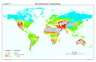
North African climate cycles have a unique history that can be traced back millions of years. The cyclic climate pattern of the Sahara is characterized by significant shifts in the strength of the North African Monsoon. When the North African Monsoon is at its strongest, annual precipitation and consequently vegetation in the Sahara region increase, resulting in conditions commonly referred to as the "green Sahara". For a relatively weak North African Monsoon, the opposite is true, with decreased annual precipitation and less vegetation resulting in a phase of the Sahara climate cycle known as the "desert Sahara".
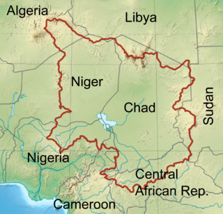
The Chad Basin is the largest endorheic basin in Africa, centered on Lake Chad. It has no outlet to the sea and contains large areas of desert or semi-arid savanna. The drainage basin is roughly coterminous with the sedimentary basin of the same name, but extends further to the northeast and east. The basin spans eight countries, including most of Chad and a large part of Niger. The region has an ethnically diverse population of about 30 million people as of 2011, growing rapidly.

Lake Nar is a brackish lake situated on the borderline between Aksaray Province and Niğde Province of central Turkey. It is around 21 metres deep and 0.7 square kilometres in area. The lake basin formed as a result of volcanic activity; specifically it is classed as a maar lake. There is still geothermal activity in the area, which has given rise to hot springs around the lake. In recent years, the geothermal waters have been pumped up to nearby hotels for use in their hot baths.
Euxinia or euxinic conditions occur when water is both anoxic and sulfidic. This means that there is no oxygen (O2) and a raised level of free hydrogen sulfide (H2S). Euxinic bodies of water are frequently strongly stratified, have an oxic, highly productive, thin surface layer, and have anoxic, sulfidic bottom water. The word euxinia is derived from the Greek name for the Black Sea- Εὔξεινος Πόντος (Euxeinos Pontos)- which translates to "hospitable sea". Euxinic deep water is a key component of the Canfield ocean, a model of oceans during the Proterozoic known as the Boring Billion proposed by Donald Canfield, an American geologist, in 1998. There is still debate within the scientific community on both the duration and frequency of euxinic conditions in the ancient oceans. Euxinia is relatively rare in modern bodies of water, but does still happen in places like the Black Sea and certain fjords.

The Owambo Basin is a sedimentary basin located on the Congo Craton in Southern Africa that extends from southern Angola into Namibia and includes the Etosha Pan. It is bound on the southern and western sides by the Damara Belt in Northern Namibia and by the Cubango River to the East. The northern boundary is scientifically disputed, but is currently mapped by most stratigraphers to include southern Angola with the boundary set at the Kunene River. The Owambo Basin is host to two famous regions: Tsumeb, a major Namibian city and site of a formerly active copper mine with exceptional mineralogical variability producing museum quality rare specimens, and Etosha National Park, the largest protected wildlife sanctuary in Namibia centered around Etosha Pan.
Jessica E. Tierney is an American paleoclimatologist who has worked with geochemical proxies such as marine sediments, mud, and TEX86, to study past climate in East Africa. Her papers have been cited more than 2,500 times; her most cited work is Northern Hemisphere Controls on Tropical Southeast African Climate During the Past 60,000 Years. Tierney is currently an associate professor of geosciences at the University of Arizona.

The African humid period (AHP) is a climate period in Africa during the Holocene during which northern Africa was wetter than today. It involved changes in Earth's orbit around the Sun, changes in vegetation and dust in the Sahara that altered the African monsoon, the disappearance of much of the Sahara desert which was replaced by grassy vegetation, trees and lakes and the settlement of the former desert by various animals and humans, who lived as hunter-gatherers. It has had profound effects on present-day Africa such as the birth of the Pharaonic civilization and the pyramids and potentially also the development of widespread Golden Age myths.