Laldighi Mosque

Last updated

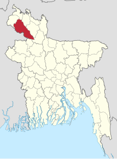
Laldighi Mosque (Bengali : লালদীঘি মসজিদ) is an ancient mosque located at Laldighi, in Badarganj upazila of Rangpur district, Bangladesh. [1]

Bengali language Indo-Aryan language spoken by the Bengali people of South Asia

Bengali, also known by its endonym Bangla, is an Indo-Aryan language primarily spoken by the Bengalis in South Asia. It is the official and most widely spoken language of Bangladesh and second most widely spoken of the 22 scheduled languages of India, behind Hindi. In 2015, 160 million speakers were reported for Bangladesh, and the 2011 Indian census counted another 100 million.

Mosque Place of worship for followers of Islam

A mosque is a place of worship for Muslims.

Bangladesh Country in South Asia

Bangladesh, officially the People's Republic of Bangladesh, is a sovereign country in South Asia. It shares land borders with India and Myanmar (Burma). The country's maritime territory in the Bay of Bengal is roughly equal to the size of its land area. Bangladesh is the world's eighth most populous country as well as its most densely-populated, to the exclusion of small island nations and city-states. Dhaka is its capital and largest city, followed by Chittagong, which has the country's largest port. Bangladesh forms the largest and easternmost part of the Bengal region. Bangladeshis include people from a range of ethnic groups and religions. Bengalis, who speak the official Bengali language, make up 98% of the population. The politically dominant Bengali Muslims make the nation the world's third largest Muslim-majority country. Islam is the official religion of Bangladesh.

Contents

History

The mosque is believed to be built in the late 17th to early 18th century. The exact date of construction is not known. There was an inscription tablet located near the eastern facade of the mosque, but this has gone missing. According to Banglapedia, the mosque's architectural style is similar to nearby mosques (such as the Gorai Mosque 1680, of Kishoreganj, and the Chaksri Mosque, circa late 17th century, of Bagerhat). [1]

<i>Banglapedia</i> national encyclopedia of Bangladesh

Banglapedia:theNational Encyclopedia of Bangladesh is the first Bangladeshi encyclopedia. It is available in print, CD-ROM format and online, in both Bengali and English. The print version comprises ten 500-page volumes. The first edition was published in January 2003 by the Asiatic Society of Bangladesh, with a plan to update it every two years. The second edition was issued in 2012.

The mosque fell into disuse, and was abandoned. During the late British rule in Bengal, this mosque was re-discovered, and cleared of the thick vegetation. [1]

Architecture

This mosques architecture is similar to Mughal sculptures.

Related Research Articles

Dinajpur District, Bangladesh District in Rangpur Division, Bangladesh

Dinajpur district is a district in the Rangpur Division of northern Bangladesh. Dinajpur is the largest district among all sixteen northern districts of Bangladesh.

Rangpur District District in Rangpur Division, Bangladesh

Rangpur is a district in Northern Bangladesh. It is a part of the Rangpur Division.

Tajhat Palace historic palace of Bangladesh

Tajhat Palace, Tajhat Rajbari, is a historic palace of Bangladesh, located in Tajhat, Rangpur. This palace now holds the Rangpur museum. Tajhat Palace is situated three km. south-east of the city of Rangpur, on the outskirts of town.

Biral Upazila Upazila in Rangpur Division, Bangladesh

Biral is an Upazila of Dinajpur District in the Division of Rangpur, Bangladesh.

Bochaganj Upazila Upazila in Rangpur Division, Bangladesh

Bochaganj is an Upazila of Dinajpur District in the Division of Rangpur, Bangladesh. Aynul Bari

Ghoraghat Upazila Upazila in Rangpur Division, Bangladesh

Ghoraghat is an Upazila of Dinajpur District in the Division of Rangpur, Bangladesh.

Kaharole Upazila Upazila in Rangpur Division, Bangladesh

Kaharole is an Upazila of Dinajpur District in the Division of Rangpur, Bangladesh.

Khansama Upazila Upazila in Rangpur Division, Bangladesh

Khansama is an upazila of Dinajpur District in the Division of Rangpur, Bangladesh.

Dinajpur Sadar Upazila Upazila in Rangpur Division, Bangladesh

Dinajpur Sadar is an Upazila of Dinajpur District in the Division of Rangpur, Bangladesh.

Saghata Upazila Upazila in Rangpur Division, Bangladesh

Saghata is an Upazila of Gaibandha District in the Division of Rangpur, Bangladesh. Village=shimultair Post=Bonarpara

Rajarhat Upazila Upazila in Rangpur Division, Bangladesh

Rajarhat is an upazila of Kurigram District in the Division of Rangpur, Bangladesh. Since 1981 it had been a Thana and later on September 14, 1983 was turned into an upazila by the government.

Nilphamari Sadar Upazila Upazila in Rangpur Division, Bangladesh

Nilphamari Sadar is an Upazila of Nilphamari District in the Division of Rangpur, Bangladesh.

Saidpur Upazila Upazila in Rangpur Division, Bangladesh

Saidpur is an Upazila of Nilphamari District in the Division of Rangpur, Bangladesh.

Badarganj Upazila Upazila in Rangpur Division, Bangladesh

Badarganj is an upazila of Rangpur District in the Division of Rangpur, Bangladesh.

Rangpur Sadar Upazila Upazila in Rangpur Division, Bangladesh

Rangpur Sadar is an Upazila of Rangpur District in the Division of Rangpur, Bangladesh.

Mithapukur Upazila Upazila in Rangpur Division, Bangladesh

Mithapukur is an upazila of Rangpur District in the division of Rangpur, Bangladesh. The upazila is situated in the middle of Rangpur, surrounded by Rangpur Sadar to the north, Pirganj to the south, Badarganj and Phulbari to the west and Pirgachha and Sundarganj to the east. Mithapukur is famous for being the birthplace of Begum Rokeya Sakhawat Hossain and its sweet mango Harivanga.

Pirganj Upazila, Rangpur Place in Rangpur Division, Bangladesh

Pirganj is an Upazila of Rangpur District in the division of Rangpur, Bangladesh. Pirganj Upazila area 409.37 km2, located in between 25°18' and 25°31' north latitudes and in between 89°08' and 89°25' east longitudes. It is bounded by mithapukur upazila on the north, palashbari, ghoraghat and nawabganj sadar (dinajpur) upazilas on the south, sadullapur upazila on the east, Mithapukur, Nawabganj Sadar (Dinajpur) and Ghoraghat upazilas on the west.

Pirganj Upazila, Thakurgaon Upazila in Rangpur Division, Bangladesh

Pirganj is an Upazila of Thakurgaon District in the Division of Rangpur, Bangladesh.

Architecture of Bangladesh

Architecture of Bangladesh is intertwined with the architecture of the Bengal region and the broader Indian subcontinent. The architecture of Bangladesh has a long history and is rooted in Bangladesh's culture, religion and history. It has evolved over centuries and assimilated influences from social, religious and exotic communities. The architecture of Bangladesh bears a remarkable impact on the lifestyle, tradition and cultural life of Bangladeshi people. Bangladesh has many architectural relics and monuments dating back thousands of years.

Chini Mosque is located in Saidpur city of Nilphamari district in Rangpur Division of Bangladesh. The mosque is also known as Glass Mosque. The construction of the mosque started in 1863 by Haji Bakir Ali Ahmed and was completed within a year as a little prayer house. Lately Wazir Ali Ahmed who's belongs from founders family started the extension and modification work of this mosque. After that in at the middle of 20th century the sons of Late Wazir Ali Ahmed, Mofizuddin Ahmed & Shafiuddin Ahmed continue the beautification work of the mosque. At the time the ceramics pieces brought form Kolkata as there was no any ceramic factory in East Pakistan/Bengal .

References

  1. 1 2 3 Bari, MA (2012). "Laldighi Mosque, Rangpur". In Islam, Sirajul; Jamal, Ahmed A. Banglapedia: National Encyclopedia of Bangladesh (Second ed.). Asiatic Society of Bangladesh.

Coordinates: 25°43′36″N88°58′51″E / 25.7266°N 88.9808°E / 25.7266; 88.9808

Geographic coordinate system Coordinate system

A geographic coordinate system is a coordinate system that enables every location on Earth to be specified by a set of numbers, letters or symbols. The coordinates are often chosen such that one of the numbers represents a vertical position and two or three of the numbers represent a horizontal position; alternatively, a geographic position may be expressed in a combined three-dimensional Cartesian vector. A common choice of coordinates is latitude, longitude and elevation. To specify a location on a plane requires a map projection.