Land's End Observatory

Last updated
Land's End Observatory
Land's End Observatory, July 2012.jpg
Land's End Observatory, West side, July 2012
USA Colorado location map.svg
Red pog.svg
Usa edcp location map.svg
Red pog.svg
Nearest city Whitewater, Colorado
Coordinates 39°1′30″N108°13′25″W / 39.02500°N 108.22361°W / 39.02500; -108.22361 Coordinates: 39°1′30″N108°13′25″W / 39.02500°N 108.22361°W / 39.02500; -108.22361
Area3.7 acres (1.5 ha)
ArchitectUS Forest Service, et al; Anderson, Ivan
Architectural styleLate 19th And Early 20th Century American Movements, rustic
NRHP reference No. 97000124 [1]
Added to NRHPFebruary 28, 1997

Land's End Observatory is a ranger observatory on the rim of Grand Mesa in Colorado. It is accessible from the Grand Mesa Scenic and Historic Byway via Land's End Road, [2] which is about half paved and half gravel. The observatory is about 10 miles west of Colorado State Highway 65. Land's End Road descends as an all-gravel road from the observatory down to U.S. Route 50, and the observatory can be accessed from that direction as well.

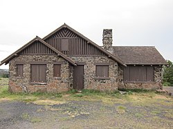
The observatory was built by the United States Forest Service and the Works Progress Administration in 1936-37, [3] with some assistance from two Civilian Conservation Corps (CCC) side camps.

A large viewing area outside the building provides a panoramic view of western Colorado and eastern Utah. As of 2022, the observatory building itself is closed and boarded up.

From the U. S. Forest Service sign outside the building:

You have reached Land's End Observatory on Colorado's highest mesa, the Grand Mesa, 10,500 feet above sea level. Built in 1936-37 by the United States Forest Service and the Works Progress Administration (WPA), the observatory reflects the rustic style of architecture found in public buildings throughout the national parks and forests. It is marked by simplicity and craftsmanship, appearing to grow out of the earth rather than intrude upon it. Basalt stones were selected from the mesa and carefully fitted together to form the walls and terrace. Wood shingles were hand- sawn. The original, handcrafted woodwork can still be found inside. Most of the WPA workers who toiled here during the Great Depression are unknown, the observatory remains their legacy.

Land's End Road was once known as the Veterans' Road. When the Great Depression left many World War I veterans unemployed, President Roosevelt responded by opening the already created Civilian Conservation Corps (CCC) to include them. Thus, between June 1933 and May 1934, the 200 veterans who were brought to Land's End camp completed 9.2 miles of road. They were paid a dollar a day for their work. Ranging in age from thirty-three to fifty-five, the veterans were hailed as "a remarkable group of men, skilled in almost every imaginable trade." They lived in army tents roughly eleven miles below the mesa rim while clearing the brush for the road. The toughest part of the Land's Ends Road, from the Wild Road Picnic Area to the rim, was completed over the next two summers by Civil Service machine operators and a few civilian workers hired by the United States Forest Service. "Built the whole road," said the project engineer, "blasting and all, without injuries."

Land's End Road descending from Land's End Observatory to U. S. Route 50. Land's End Observatory viewing area, looking towards the north..jpg
Land's End Road descending from Land's End Observatory to U. S. Route 50.
Land's End Observatory viewing area, looking towards the north. Land's End Road descending from Land's End Observatory to U. S. Route 40..jpg
Land's End Observatory viewing area, looking towards the north.

Related Research Articles

<span class="mw-page-title-main">Civilian Conservation Corps</span> US voluntary public work relief program from 1933-42

The Civilian Conservation Corps (CCC) was a voluntary government work relief program that ran from 1933 to 1942 in the United States for unemployed, unmarried men ages 18–25 and eventually expanded to ages 17–28. The CCC was a major part of President Franklin D. Roosevelt's New Deal that supplied manual labor jobs related to the conservation and development of natural resources in rural lands owned by federal, state, and local governments. The CCC was designed to supply jobs for young men and to relieve families who had difficulty finding jobs during the Great Depression in the United States.

<span class="mw-page-title-main">Fruita, Colorado</span> City in Colorado, United States

The City of Fruita is a home rule municipality located in western Mesa County, Colorado, United States. The city population was 13,395 at the 2020 United States Census. Fruita is a part of the Grand Junction, CO Metropolitan Statistical Area and lies within the Grand Valley. The geography is identified by the bordering Colorado River on the southern edge of town, the Uncompahgre Plateau known for its pinyon-juniper landscape, and the Book Cliffs range on the northern edge of the Grand Valley. Originally home to the Ute people, white farmers settled the town after founder William Pabor in 1884. Ten years later, Fruita was incorporated.

<span class="mw-page-title-main">Colorado National Monument</span> National Park Service unit in Colorado, United States

Colorado National Monument is a National Park Service unit near the city of Grand Junction, Colorado. Sheer-walled canyons cut deep into sandstone and granite–gneiss–schist rock formations. This is an area of desert land high on the Colorado Plateau, with pinyon and juniper forests on the plateau. The park hosts a wide range of wildlife, including red-tailed hawks, golden eagles, ravens, jays, desert bighorn sheep, and coyotes. Activities include hiking, horseback riding, road bicycling, and scenic drives; a visitor center on the west side contains a natural history museum and gift shop. There are scenic views from trails, Rim Rock Drive, which winds along the plateau, and the campground. Nearby are the Book Cliffs and the largest flat-topped mountain in the world, the Grand Mesa.

<span class="mw-page-title-main">Bandelier National Monument</span> United States historic place

Bandelier National Monument is a 33,677-acre (13,629 ha) United States National Monument near Los Alamos in Sandoval and Los Alamos counties, New Mexico. The monument preserves the homes and territory of the Ancestral Puebloans of a later era in the Southwest. Most of the pueblo structures date to two eras, dating between 1150 and 1600 AD.

<span class="mw-page-title-main">Flandrau State Park</span> United States historic place

Flandrau State Park is a state park of Minnesota, United States, on the Cottonwood River adjacent to the city of New Ulm. Initially called Cottonwood River State Park, it was renamed in 1945 to honor Charles Eugene Flandrau, a leading citizen of early Minnesota who commanded defenses during the Battles of New Ulm in the Dakota War of 1862. The park was originally developed in the 1930s as a job creation project to provide a recreational reservoir. However the dam was repeatedly damaged by floods and was removed in 1995.

<span class="mw-page-title-main">Laurel Hill State Park</span>

Laurel Hill State Park is a 3,935-acre (1,592 ha) Pennsylvania state park in Jefferson and Middlecreek Townships, Somerset County, Pennsylvania in the United States. Laurel Hill Lake is a 63-acre (25 ha) man-made lake with a dam that was constructed during the Great Depression by the young men of CCC camps SP-8-PA and SP-15-PA. Laurel Hill State Park is 8 miles (13 km) from Interstate 76 just off Pennsylvania Route 31 near Bakersville and on Pennsylvania Route 653 near Trent.

<span class="mw-page-title-main">Backbone State Park</span> State park in Iowa

Backbone State Park is Iowa's oldest state park, dedicated in 1919. Located in the valley of the Maquoketa River, it is approximately three miles (5 km) south of Strawberry Point in Delaware County. It is named for a narrow and steep ridge of bedrock carved by a loop of the Maquoketa River originally known as the Devil's Backbone. The initial 1,200 acres (490 ha) were donated by E.M. Carr of Lamont, Iowa. Backbone Lake Dam, a relatively low dam built by the Civilian Conservation Corps (CCC) in the 1930s, created Backbone Lake. The CCC constructed a majority of trails and buildings which make up the park.

<span class="mw-page-title-main">Copper Falls State Park</span> State park in Ashland County, Wisconsin

Copper Falls State Park is a 3,068-acre (1,242 ha) state park in Wisconsin. The park contains a section of the Bad River and its tributary the Tylers Forks, which flow through a gorge and drop over several waterfalls. Old Copper Culture Indians and later European settlers mined copper in the area. The state park was created in 1929 and amenities were developed by the Civilian Conservation Corps and the Works Progress Administration. In 2005 the park was listed on the National Register of Historic Places as a site with 10 contributing properties.

<span class="mw-page-title-main">Saddlehorn Caretaker's House and Garage</span> Historic house in Colorado, United States

The Saddlehorn Caretaker's House and Garage, also known as the Stone House, the Rock House, and the Superintendent's Quarters is a house and asset listed as part of the National Register of Historic Places located in the Colorado National Monument.

<span class="mw-page-title-main">Rim Rock Drive</span> United States historic place

Rim Rock Drive is a scenic road in Colorado National Monument. The 23-mile (37 km) drive follows the upper rim of a series of canyons, extending from the vicinity of Fruita, Colorado, in the west to near Grand Junction, Colorado, in the east, connecting points only 8 miles (13 km) miles apart in a straight line. The entire road has been designated a historic district on the National Register of Historic Places.

<span class="mw-page-title-main">Okmulgee Park</span>

Okmulgee Park is a city park in Okmulgee, Oklahoma in the United States. The park contains 1,075 acres (435 ha) and sits at an elevation of 758 feet (231 m). The park is adjacent to Dripping Springs Park and is located on Okmulgee Lake. Okmulgee Park, a municipal park established in 1963, is open for year-round recreation including camping, fishing, swimming and hiking.

<span class="mw-page-title-main">Oak Lodge</span> United States historic place

Oak Lodge is a historic recreational building, located on the west side of Schreeder Pond in Chatfield Hollow State Park in Killingworth, Connecticut. Built in 1937, it is one of Connecticut's finest examples of construction by crews of the Civilian Conservation Corps (CCC). It, along with Schreeder Pond and other CCC-built park features, was listed on the National Register of Historic Places in 1986.

<span class="mw-page-title-main">Colorado State Highway 65</span>

State Highway 65 (SH 65) is a state highway in Colorado that crosses the Grand Mesa. The highway along with a road to Lands End Overlook were designated as the Grand Mesa National Scenic Byway in 1996. SH 65's southern terminus is at SH 92 east of Delta, and its northern terminus is at Interstate 70 (I-70) and U.S. Route 6 (US 6) northeast of Palisade.

<span class="mw-page-title-main">Mondeaux Dam Recreation Area</span> United States historic place

The Mondeaux Dam Recreation Area is a public park in the forest in the town of Westboro, Wisconsin, United States. The Civilian Conservation Corps (CCC) and Work Projects Administration (WPA) created the lake and facilities during the Great Depression.

Architects of the National Park Service are the architects and landscape architects who were employed by the National Park Service (NPS) starting in 1918 to design buildings, structures, roads, trails and other features in the United States National Parks. Many of their works are listed on the National Register of Historic Places, and a number have also been designated as National Historic Landmarks.

<span class="mw-page-title-main">Lacey-Keosauqua State Park</span> State park in Iowa

Lacey-Keosauqua State Park is located southwest of Keosauqua, Iowa, United States. The park is located along the Des Moines River in Van Buren County. First dedicated in 1921, it is the largest state park in size in Iowa. In 1990, three areas were named nationally recognized historic districts and listed on the National Register of Historic Places.

<span class="mw-page-title-main">Ricker Pond State Park</span> State park in Caledonia County, Vermont

Ricker Pond State Park is a state park in Groton, Vermont in the United States. It is one of seven state parks located in Groton State Forest. The park is just off Vermont Route 232. The park provides public access to Ricker Pond, a 95-acre (38 ha) lake in central Groton, and was developed in the 1930s by crews of the Civilian Conservation Corps. Activities includes camping, motor boating, waterskiing, fishing, swimming, paddling, horseback riding, hiking, mountain biking, snowshoeing and cross-country skiing. The park is open between the Memorial Day and Columbus Day weekends; fees are charged for day use and camping.

The Stowe CCC Side Camp, now known as the Vermont State Ski Dorm, is a historic residence hall at 6992 Mountain Road in Stowe, Vermont. Built in 1935 by crews of the Civilian Conservation Corps, it is one of the largest surviving CCC-built housing units to survive in the state. It was converted for use as a ski lodge after World War II. It was listed on the National Register of Historic Places in 2002.

Civilian Conservation Corp Camp F-10, also called the Rockerville Civilian Conservation Corp Camp, is a historic district on Silver Mountain Road, 15 miles (24 km) southwest of Rapid City, South Dakota. Between 1933 and 1935, it functioned as a base camp for Civilian Conservation Corps (CCC) workers who were employed on multiple construction and forestry projects in the area during the Great Depression. The camp was added to the National Register of Historic Places in 2004; three buildings and the remains of a fireplace are included in the listing.

The Grand Mesa National Scenic Byway is a 63-mile (101 km) National Scenic Byway, National Forest Scenic Byway, and Colorado Scenic and Historic Byway located in Delta and Mesa counties, Colorado, USA. The byway traverses Grand Mesa, the most extensive flat-topped mountain on Earth, and reaches an elevation of 10,849 feet (3,307 m). The byway comprises Colorado State Highway 65 from Cedaredge to Interstate 70 Exit 49 and Forest Service Road 100 to the Land's End Observatory.

References

  1. "National Register Information System". National Register of Historic Places . National Park Service. March 13, 2009.
  2. "Grand Mesa, Uncompahgre and Gunnison National Forests". National Forest Service. Retrieved 2007-08-23.
  3. Office of Archaeology and Historic Preservation (June 2006). "New Deal in Colorado 1933-1942" (PDF). Colorado Historical Society. Retrieved 2007-08-23.

Commons-logo.svg Media related to Land's End Observatory at Wikimedia Commons