Langenholtensen

Last updated
Wappen Langenholtensen.png

Langenholtensen is a village near the town of Northeim and part of that town, in Lower Saxony. The name comes from Holzhausen, a quite frequently occurring place-name in Germany.

Northeim Place in Lower Saxony, Germany

Northeim is a town in Lower Saxony, Germany, seat of the district of Northeim, with, in 2011, a population of 29,000. It lies on the German Half-Timbered House Road.

Lower Saxony State in Germany

Lower Saxony is a German state (Land) situated in northwestern Germany. It is the second-largest state by land area, with 47,624 km2 (18,388 sq mi), and fourth-largest in population among the 16 Länder federated as the Federal Republic of Germany. In rural areas, Northern Low Saxon and Saterland Frisian are still spoken, but the number of speakers is declining.

Contents

Geography

The village of Langenholtensen lies just north of Northeim. It is located between the Edesheimer forest in the north, the Rethoberg in the northeast, and the Sultmerberg in the west.

The Arms

The village's arms or blazon were granted on October 1 1951. The lower part of the arms symbolize the Luther-oak in the village, planted in 1833 and now a natural monument. It is symbolized by the oak leaves and the Luther rose with the cross, taken from the arms of German reformer Martin Luther. The chief shows a staff, symbol of the Amt Brunstein court, which was situated in Langenholtensen. [1]

Luther rose

The Luther seal or Luther rose is a widely recognized symbol for Lutheranism. It was the seal that was designed for Martin Luther at the behest of John Frederick of Saxony in 1530, while Luther was staying at the Coburg Fortress during the Diet of Augsburg. Lazarus Spengler, to whom Luther wrote his interpretation below, sent Luther a drawing of this seal. Luther saw it as a compendium or expression of his theology and faith, which he used to authorize his correspondence. Luther informed Philipp Melanchthon on September 15, 1530, that the Prince had personally visited him in the Coburg fortress and presented him with a signet ring, presumably displaying the seal.

Germany Federal parliamentary republic in central-western Europe

Germany, officially the Federal Republic of Germany, is a country in Central and Western Europe, lying between the Baltic and North Seas to the north, and the Alps to the south. It borders Denmark to the north, Poland and the Czech Republic to the east, Austria and Switzerland to the south, France to the southwest, and Luxembourg, Belgium and the Netherlands to the west.

Martin Luther Saxon priest, monk and theologian, seminal figure in Protestant Reformation

Martin Luther, was a German professor of theology, composer, priest, monk, and a seminal figure in the Protestant Reformation.

History

The Protestant priest Johannes Letzner was appointed to the village in 1564. Despite the fact that the Luther rose is incorporated into the village's arms, there is no evidence that Martin Luther ever visited Langenholtensen.

Johannes Letzner was a Renaissance-era German Protestant priest and historian of Lower Saxony, in particular of Brunswick-Lüneburg.

Population

Related Research Articles

Wittenberg Place in Saxony-Anhalt, Germany

Wittenberg, officially Lutherstadt Wittenberg, is a town in Saxony-Anhalt, Germany. Wittenberg is situated on the River Elbe, 60 kilometers (37 mi) north of Leipzig and 90 kilometers (56 mi) south-west of Berlin, and has a population of 48,501 (2008).

Emsland District in Lower Saxony, Germany

Landkreis Emsland is a district in Lower Saxony, Germany named after the river Ems. It is bounded by the districts of Leer, Cloppenburg and Osnabrück, the state of North Rhine-Westphalia, the district of Bentheim in Lower Saxony, and the Netherlands.

Hildesheim is a district (Landkreis) in Lower Saxony, Germany. It is bounded by the districts of Hanover, Peine, Wolfenbüttel, Goslar, Northeim, Holzminden and Hamelin-Pyrmont.

Holzminden (district) District in Lower Saxony, Germany

Holzminden is a district in Lower Saxony, Germany. It is bounded by the districts of Hamelin-Pyrmont, Hildesheim and Northeim, and by the state of North Rhine-Westphalia.

Northeim is a district in Lower Saxony, Germany. It is bounded by the districts of Holzminden, Hildesheim, Goslar and Göttingen, and the state of Hesse.

Göttingen is a district in Lower Saxony, Germany. It is bounded by the districts of Northeim and Goslar, and by the states of Thuringia and Hesse.

Goslar (district) District in Lower Saxony, Germany

Goslar is a district in Lower Saxony, Germany. It is bounded by the districts of Göttingen, Northeim, Hildesheim and Wolfenbüttel, the city of Salzgitter, and by the states of Saxony-Anhalt and Thuringia (Nordhausen).

Osterode was a district in Lower Saxony, Germany. It was bounded by the districts of Göttingen, Northeim and Goslar, and by the state of Thuringia.

Höxter (district) District in North Rhine-Westphalia, Germany

Höxter is a Kreis (district) in the east of North Rhine-Westphalia, Germany. Neighboring districts are Holzminden, Northeim, Kassel, Waldeck-Frankenberg, Hochsauerland, Paderborn, and Lippe.

Stendal is a district (Landkreis) in the north-east of Saxony-Anhalt, Germany. Its neighbouring districts are : Jerichower Land, Börde, Altmarkkreis Salzwedel, Lüchow-Dannenberg in Lower Saxony, and the districts of Prignitz, Ostprignitz-Ruppin and Havelland in Brandenburg.

Gubin, Poland Place in Lubusz, Poland

Gubin is a town in Krosno Odrzańskie County, Lubusz Voivodeship, in southwestern Poland. It is the administrative seat of the rural Gmina Gubin, though not part of it.

Eichsfeld historical region in Lower Saxony and Thuringia, in the Harz mountains

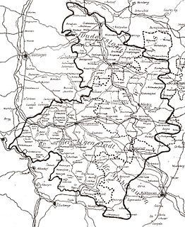
The Eichsfeld is a historical region in the southeast of the state of Lower Saxony and northwest of the state of Thuringia in the south of the Harz mountains in Germany. Until 1803 the Eichsfeld was for centuries part of the Archbishopric of Mainz, which is the cause of its current position as a Catholic enclave in the predominantly Protestant north of Germany. Following German partition in 1945, the West German portion became Landkreis Duderstadt. A few small transfers of territory between the American and Soviet zones of occupation took place in accordance with the Wanfried Agreement.

Camenca Place in Transnistria, Moldova

Camenca is a town in Transnistria, Moldova. It is composed of the town itself, and the village of Solnecinoe. Camenca is the seat of Camenca District.

Susz Place in Warmian-Masurian, Poland

Susz is a town in Iława County, Warmian-Masurian Voivodeship, Poland, with 5,600 inhabitants (2004).

Zabór Village in Lubusz, Poland

Zabór is a village in Zielona Góra County, Lubusz Voivodeship, in western Poland. It is the seat of the gmina called Gmina Zabór. It lies approximately 15 km (9 mi) east of Zielona Góra.

Echte is a village in the Gemeinde Kalefeld in the district of Northeim in northern Germany with about 1,380 inhabitants.

Hils mountain range

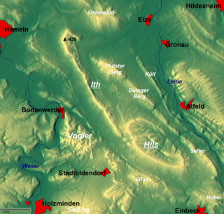
The Hils is a range of hills in Germany's Central Uplands that is up to 480.4 m high. It is located in the districts of Holzminden, Hildesheim and Northeim, in the state of Lower Saxony.

Mackensen is a village of about 450 inhabitants which is incorporated into the city of Dassel since 1974.

Heber (hills) mountain range

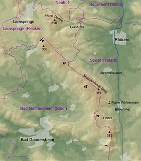
The Heber is a hogback ridge, relatively small in area and up to 313.5 metres high, in the Lower Saxon Hills within the districts of Goslar, Northeim and Hildesheim in the German state of Lower Saxony.

References

Coordinates: 51°43′N10°01′E / 51.717°N 10.017°E / 51.717; 10.017

Geographic coordinate system Coordinate system

A geographic coordinate system is a coordinate system that enables every location on Earth to be specified by a set of numbers, letters or symbols. The coordinates are often chosen such that one of the numbers represents a vertical position and two or three of the numbers represent a horizontal position; alternatively, a geographic position may be expressed in a combined three-dimensional Cartesian vector. A common choice of coordinates is latitude, longitude and elevation. To specify a location on a plane requires a map projection.