
The 1961 Atlantic hurricane season was a hyperactive Atlantic hurricane season, with an accumulated cyclone energy (ACE) total of 189. The season, however, was an average one in terms of named storms. The season featured eight hurricanes and a well above average number of five major hurricanes. It was previously thought that the season had a record-tying seven major hurricanes, before the Atlantic hurricane reanalysis project downgraded two storms in 2019. Two Category 5 hurricanes were seen in 1961, making it one of only seven Atlantic hurricane seasons to feature multiple Category 5 hurricanes in one season. The season started on June 15, and ended on November 15. These dates conventionally delimit the period of each year when most tropical cyclones form in the Atlantic basin. The first system, an operationally unclassified tropical depression, formed offshore east Central Florida on June 10, but dissipated a few days later. Next, Hurricane Anna developed in the eastern Caribbean Sea near the Windward Islands on July 20. It brought minor damage to the islands, as well as wind and flood impacts to Central America after striking Belize as a hurricane. Anna caused one death and about $300,000 (1961 USD) in damage. Activity went dormant for nearly a month and a half, until Hurricane Betsy developed on September 2. Betsy peaked as a Category 4 hurricane, but remained at sea and caused no impact.

The 1962 Atlantic hurricane season featured Hurricanes Daisy and Ella – two tropical cyclones that showed the latest dates for the fourth and fifth named storms on record since tropical cyclones were first named in the North Atlantic ocean, starting in 1950, when they both formed on September 29 and October 14. On the same hand, it was the least active since 1939, with only five named storms. Although the season officially began on June 15, the first named storm did not form until August 26, the third-latest date. Hurricane Alma brushed the Outer Banks before becoming extratropical southeast of New England, destroying hundreds of boats and producing beneficial rainfall. In late August, Tropical Storm Becky developed unusually far east in the Atlantic Ocean, becoming the easternmost storm on record to recurve to the northeast. Celia followed in the September, forming east of the Lesser Antilles and executing a loop near Bermuda before dissipating. Hurricane Daisy, the latest fourth named storm, was the costliest of the season, leaving about $1.1 million in damage in New England (1962 USD). The storm dropped the highest rainfall total on record in Maine, and its precipitation caused 22 traffic fatalities. The final hurricane – Ella – the latest fifth named storm – was also the strongest, remaining offshore of the eastern United States but causing two deaths.

The 1976 Atlantic hurricane season was an above average Atlantic hurricane season in which 21 tropical or subtropical cyclones formed. 10 of them became nameable storms. Six of those reached hurricane strength, with two of the six became major hurricanes, which are Category 3 or higher on the Saffir–Simpson scale. The season officially began on June 1 and lasted until November 30. These dates conventionally delimit the period of each year when most tropical cyclones form in the Atlantic basin. However, the first system, a subtropical storm, developed in the Gulf of Mexico on May 21, several days before the official start of the season. The system spawned nine tornadoes in Florida, resulting in about $628,000 (1976 USD) in damage, though impact was minor otherwise.

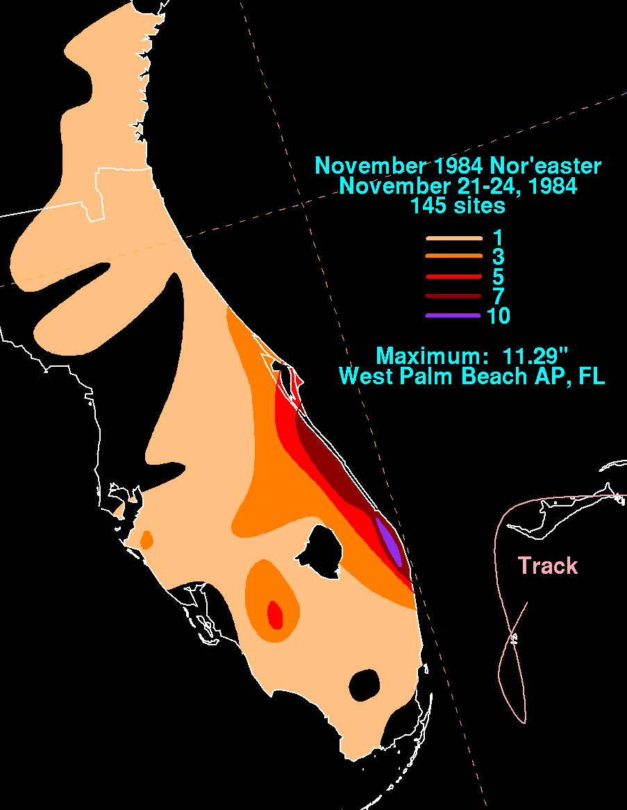
The 1984 Atlantic hurricane season was the most active since 1971, though the season was below average in hurricanes and major hurricanes. It officially began on June 1, 1984, and lasted until November 30, 1984. These dates conventionally delimit the period of each year when most tropical cyclones form in the Atlantic basin. The 1984 season was an active one in terms of named storms, but most of them were weak and stayed at sea. Most of the cyclones tracked through the northwest subtropical Atlantic west of the 50th meridian to near the Eastern coast of the United States between mid-August and early October. The most damaging storm was Hurricane Klaus, which caused $152 million (1984 dollars) in damage in Puerto Rico. Hurricane Diana was the first hurricane to strike a nuclear power plant without incident; it was also the first major hurricane to strike the U.S. East Coast in nearly 20 years. Also of note was Hurricane Lili, which lasted well after the official end of the season. It was downgraded from a named storm on December 24. Damage overall from the tropical cyclones in 1984 totaled $228.7 million. Unusually, no hurricanes developed from tropical waves in 1984, which usually are the source of the strongest storms in an Atlantic hurricane season.

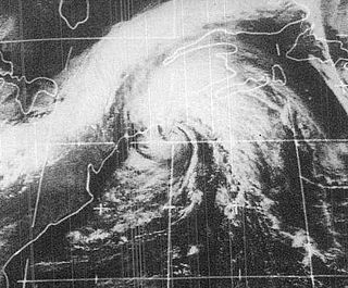
The 1952 Groundhog Day Storm was the only Atlantic tropical cyclone on record in February. First observed in the western Caribbean Sea on February 2 as a non-frontal low, it moved rapidly throughout its duration and struck southwestern Florida early the next day as a gale-force storm. In the state, the winds damaged some crops and power lines, but no serious damage was reported. The system became a tropical storm after emerging over the Atlantic Ocean before quickly transitioning into an extratropical cyclone on February 4. Strong winds and waves washed a freighter ashore, but no injuries were related to the event. Subsequently, the storm brushed eastern New England, causing minor power outages, before it moved inland near Maine. There were no reported fatalities related to the storm.

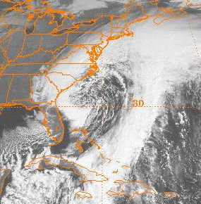
Hurricane Diana was the first major hurricane to hit the East Coast of the United States in nearly 20 years. Diana was the ninth tropical cyclone, fourth named storm, first hurricane, and first major hurricane of the 1984 Atlantic hurricane season. It caused moderate damage in North Carolina while it looped offshore and after it made landfall as a Category 2 hurricane. Forming on September 8, Diana moved northward and wandered across North Carolina for a couple of days during mid-September, dropping heavy rainfall. Once it left the state and accelerated east-northeast, Diana quickly evolved into an extratropical cyclone. Watches and warnings were issued for the storm along the East coast between eastern Florida and Virginia. Damages to the United States totaled $65.5 million. Three indirect fatalities were caused by the cyclone.

The 1991 Perfect Storm, also known as The No-Name Storm and the Halloween Gale/Storm, was a nor'easter that absorbed Hurricane Grace, and ultimately evolved into a small unnamed hurricane itself late in its life cycle.

The 1982 Florida subtropical storm, officially known as Subtropical Storm One, was the only subtropical cyclone of the exceptionally inactive 1982 Atlantic hurricane season. The storm originated from two different systems around the Gulf of Mexico and Caribbean on June 16. The systems merged into trough while a circulation began to form off the coast of Florida on June 18. The depression made landfall in Florida and strengthened into a storm over land. The storm entered the Atlantic Ocean and headed to the northeast, becoming extratropical on June 20 near Newfoundland. The storm was the only system of 1982 to affect the eastern half of the United States, and it caused three fatalities and caused $10 million in damage.
Tropical Storm Carrie was a strong tropical storm that affected the East Coast of the United States in early September 1972. The third tropical cyclone of the 1972 Atlantic hurricane season, Carrie formed on August 29 from a complex sequence of meteorological events starting with the emergence of a tropical wave into the Atlantic in the middle of August. Tracking generally northward throughout its life, Carrie reached an initial peak intensity as a moderate tropical storm before nearly weakening back into tropical depression status. The storm began to intensify in a baroclinic environment after turning toward the northwest, its winds of 70,000 miles per hour (110,000 km/h) as it was transitioning into an extratropical system eclipsed the cyclone's previous maximum strength. The extratropical remnants of Carrie skirted eastern New England before making the landfall in Maine on September 4 and dissipating over the Gulf of Saint Lawrence during the next two days.

The Christmas 1994 nor'easter was an intense cyclone along the East Coast of the United States and Atlantic Canada. It developed from an area of low pressure in the southeast Gulf of Mexico near the Florida Keys, and moved across the state of Florida. As it entered the warm waters of the Gulf Stream in the Atlantic Ocean, it began to rapidly intensify, exhibiting traits of a tropical system, including the formation of an eye. It attained a pressure of 970 millibars on December 23 and 24, and after moving northward, it came ashore near New York City on Christmas Eve. Because of the uncertain nature of the storm, the National Hurricane Center (NHC) did not classify it as a tropical cyclone.
The November 2006 nor'easter was a powerful extratropical cyclone that formed offshore of the Southeastern United States on November 20, bringing heavy rains, high winds, beach erosion, and coastal flooding to the Carolinas and southern New England. In addition, the earliest snowfall ever noted in both Charleston, South Carolina and Savannah, Georgia occurred on the southwest side of this cyclone. Over 10,000 were without power during the storm. No longer a nor'easter, the extratropical cyclone accelerated rapidly across the North Atlantic while rapidly strengthening, becoming a cyclonic storm again by November 25, but this time with hurricane-force sustained winds. The intense low made a cyclonic loop west of Iceland, before being absorbed by another strengthening extratropical cyclone to the west of Great Britain, late on December 1.
Hurricane Bertha caused minor damage in the United States, Bermuda, and Atlantic Canada in July and August 1990. The third tropical cyclone, second named storm, and first hurricane of the 1990 Atlantic hurricane season, Bertha developed from a frontal low pressure area offshore of North Carolina on July 24. Initially subtropical, it slowly acquired tropical characteristics while tracked southeast and then southwestward. By early on July 27, the cyclone was re-classified as a tropical depression. Following its transition, the depression intensified and was upgraded to Tropical Storm Bertha on July 28. The storm then curved northeastward and rapidly strengthened. Bertha became a hurricane early on July 29, though it weakened back to a tropical storm later that day. On the following day, Bertha re-intensified into a hurricane and peaked as an 80 mph (130 km/h) Category 1 hurricane on July 31.
Subtropical Storm Andrea was the first named storm to form in May in the Atlantic Ocean in 26 years. Andrea caused large waves and tropical-storm force winds along the southeast coast of the United States. The first named storm and the first subtropical cyclone of the 2007 Atlantic hurricane season, Andrea developed out of a non-tropical low on May 9 about 150 miles (240 km) northeast of Daytona Beach, Florida, three weeks before the official start of the season. After encountering dry air and strong vertical wind shear, Andrea weakened to a subtropical depression on May 10 while remaining nearly stationary, and the National Hurricane Center discontinued advisories early on May 11. Andrea's remnant was subsequently absorbed into another extratropical storm on May 14. Andrea was the first pre-season storm to develop since Tropical Storm Ana in April 2003. Additionally, the storm was the first Atlantic named storm in May since Tropical Storm Arlene in 1981.

The 1925 Florida tropical storm was the deadliest tropical cyclone to impact the United States that did not become a hurricane. The fourth and final storm of the season, it formed as a tropical depression on November 27 near the Yucatán Peninsula, the system initially tracked southeastward before turning north as it gradually intensified. After skirting western Cuba on November 30, the storm reached peak winds of 65 mph (105 km/h) before striking central Florida on December 1. Within hours, the system transitioned into an extratropical cyclone and emerged into the Atlantic Ocean. The system moved onshore once more on December 2 in North Carolina before turning east, away from the United States. On December 5, the system is presumed to have dissipated offshore.

Hurricane Grace was a short-lived Category 2 hurricane that contributed to the formation of the powerful 1991 Perfect Storm. Forming on October 26, Grace initially had subtropical origins, meaning it was partially tropical and partially extratropical in nature. It became a tropical cyclone on October 27, and ultimately peaked with winds of 105 mph (165 km/h). The storm had minor effects on the island of Bermuda as it passed to the south. A developing extratropical storm to the north turned Grace eastward; the hurricane was eventually absorbed into the large circulation of the larger low-pressure system. Fed by the contrast between cold air to the northwest and warm air from the remnants of Grace, this storm became a large and powerful Nor'easter that caused extremely high waves and resulted in severe coastal damage along the East Coast of the United States.

Hurricane Alma saw the latest development of the first storm since 1941. The first named storm of the 1962 Atlantic hurricane season, Alma formed from a tropical wave located offshore South Florida on August 26. Initially a tropical depression, it subsequently moved inland over South Florida. Impact in the state was minor, generally limited to light rainfall and rough seas. Early on August 27, the depression reemerged into the Atlantic Ocean and strengthened into Tropical Storm Alma later that day. Thereafter, it moved northeastward and remained offshore the East Coast of the United States. Alma strengthened into a hurricane on August 28, while located offshore the Outer Banks of North Carolina. In the eastern portion of the state, strong winds downed electrical poles, which caused power outages. Storm tides caused erosion in some areas. Damage in North Carolina reached $35,000 (1962 USD).

The March 2014 nor'easter was an extremely powerful extratropical cyclone that affected much of U.S. Gulf Coast, the eastern United States, eastern Canada, and Greenland. It was the most powerful winter storm of the 2013–14 North American winter storm season, being an unusually large winter storm as well, with its gale-force wind field becoming four times larger than that of Hurricane Sandy's extratropical remnant. The storm affected various parts of the Midwest, most of the Eastern Seaboard, as well as eastern Canada, bringing extremely powerful winds, and blizzard-like conditions.

The March 1969 nor'easter was an extratropical cyclone that moved into the Gulf of Mexico on March 5, moving through southern Georgia, then deepened as it moved along the lower Eastern Seaboard, before swinging wide of New England and Atlantic Canada. Heavy snows fell across eastern Maryland, southern Delaware, and Martha's Vineyard in Massachusetts. It was a strong system, with maximum sustained winds of 80 kn (150 km/h) a central pressure close to 950 hPa (28 inHg) while south of Atlantic Canada. The system then moved into the far northern Atlantic Ocean while splitting into two low pressure areas on March 10.

Tropical Storm Melissa was a nor'easter and a short-lived tropical storm that affected portions of the U.S. East Coast and Atlantic Canada in October 2019. The fourteenth depression and thirteenth named storm of the 2019 Atlantic hurricane season, Melissa originated from a cold front that developed over the southwestern Atlantic on October 6. The system developed tropical storm-force winds on October 8, before becoming a nor'easter on the next day. The system then began to organize, and was designated as Subtropical Storm Melissa on October 11. Melissa was then upgraded into a tropical storm, the following day. However, the storm soon began to disorganize and transition into an extratropical low by October 14, before dissipating later that same day.

The October 2021 nor'easter, which eventually became Tropical Storm Wanda, was an erratic nor'easter and tropical cyclone that struck the East Coast of the United States, and meandered across the northern Atlantic Ocean in early November 2021. The powerful extratropical cyclone affected much of the East Coast, causing significant flooding in areas which were previously affected by hurricanes Henri and Ida. As Wanda, the cyclone was the twenty-first and final tropical cyclone of the 2021 Atlantic hurricane season. The system originated from a non-tropical disturbance over the Southern United States on October 23, subsequently moved out into the Atlantic. The storm quickly developed into a powerful bomb cyclone off the East Coast of the United States on October 27, causing flooding and bringing powerful gale-force winds to the region in the process. The system then weakened and moved eastward, further out into the Atlantic. On October 31, at 03:00 UTC, the system transitioned into a subtropical storm and was given the name Wanda. As the system slowly curved southeastward, it continued organizing, before transitioning into a fully-tropical storm on November 1. Over the next several days, Wanda subsequently moved northward, before curving southward and then accelerating northeastward, before degenerating into a post-tropical cyclone on November 7. On the next day, Wanda's remnant was absorbed into a larger extratropical cyclone to the north.


