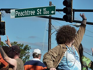
Peachtree Street is one of several major streets running through the city of Atlanta. Beginning at Five Points in downtown Atlanta, it runs North through Midtown; a few blocks after entering into Buckhead, the name changes to Peachtree Road at Palisades Road. Much of the city's historic and noteworthy architecture is located along the street, and it is often used for annual parades,, as well as one-time parades celebrating events such as the 100th anniversary of Coca-Cola in 1986 and the Atlanta Braves' 1995 World Series victory.

Buckhead is an affluent uptown commercial and residential district of Atlanta, Georgia, comprising approximately the northernmost fifth of the city.

State Route 141 (SR 141) is a 28.0-mile-long (45.1 km) state highway that runs southwest-to-northeast in the northwest part of the U.S. state of Georgia. It connects the Buckhead area of Atlanta with Cumming. Its routing exists within portions of Fulton, DeKalb, Gwinnett, Forsyth counties.
The Neighborhood Planning Unit is a neighborhood-scale governmental structure used in the city of Atlanta, Georgia.
Through much of the 19th century, Pace's Ferry was an important ferry across the Chattahoochee River near Atlanta. Started in the early 1830s near Peachtree Creek, it was run by Hardy Pace, one of the city's founders. It was an important transportation link to northwestern Georgia, especially prior to the construction of the State Road to Chattanooga.

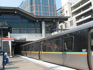
Arts Center station is a train station in Atlanta, Georgia, serving the Red and Gold lines of the Metropolitan Atlanta Rapid Transit Authority (MARTA) rail system. It is the northernmost of three MARTA stations that serve Midtown Atlanta, the others being Midtown and North Avenue.

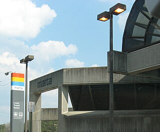
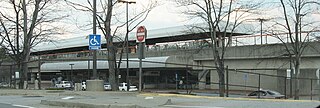
Buckhead is a train station in Atlanta, Georgia, serving the Red Line of the Metropolitan Atlanta Rapid Transit Authority (MARTA) rail system. This station is the first station only served by the Red Line. It is located in the Buckhead neighborhood in the median of State Route 400, a limited access highway, at Peachtree Road/State Route 141. The station is in easy walking distance of many offices, hotels and shopping centers, including Lenox Square, although the Lenox MARTA station provides easier access to the mall. The buc, a zero-fare bus service, also provides transportation to the surrounding area. The Buckhead Station also features Zipcars.
Brookhaven/Oglethorpe is a train station in Brookhaven, Georgia, on the Gold Line of the Metropolitan Atlanta Rapid Transit Authority (MARTA) rail system. An elevated station, it is located one mile south of Oglethorpe University. The station provides connecting bus service to North Druid Hills, Toco Hills, North DeKalb Mall, the Peachtree Boulevard business district, and the Georgia Department of Labor.

Medical Center is a metro station in Sandy Springs, Georgia, serving the Red Line of the Metropolitan Atlanta Rapid Transit Authority (MARTA) rail system. It serves the Pill Hill neighborhood of Perimeter Center, the location of Northside Hospital, St. Joseph's Hospital, and Children's Healthcare of Atlanta at Scottish Rite and DeVry University. North of Medical Center is Dunwoody station and south is Buckhead station. This station's platforms are long enough to accommodate 6-car trains.

Chastain Memorial Park is the largest city park in Atlanta, Georgia. It is a 268-acre (1.08 km2) park near the northern edge of the city. Included in the park are jogging paths, playgrounds, tennis courts, a golf course, swimming pool, horse park and amphitheater.
Hunter Hills is a neighborhood located west of downtown Atlanta, Georgia, United States. Its motto, "One Community, One Family", has been its cornerstone since 2001. The neighborhood is encompassed in the 30314 zip code. Hunter Hills shares borders with Mozley Park, Dixie Hills and West Lake neighborhoods. The neighborhood rests just inside Atlanta's perimeter highway I-285, and U.S. Route 78. The schools that serve the neighborhood are Stanton Elementary, Carter G. Woodson Elementary School, Ron Clark Academy, Herndon Elementary and Washington High School, and the Atlanta Job Corps. City of Refuge, a community-based 501(c)(3) non-profit, was established on the 1300 block of Joseph E. Boone Blvd. in 2003 and helps to bring transformation to individuals and families through services including housing, health and wellness, vocational training, and youth development.

Pine Hills is a neighborhood of Atlanta, Georgia and also part of the Buckhead Community, located in north east Atlanta on the eastern part of Buckhead. Many homes in Pine Hills are also located in Brookhaven, GA. It is roughly bounded by Buford Highway to the south, the railway to the north, Lenox Road to the west and East Roxboro Road to the east. The western and central section of Pine Hills is in Fulton County and a smaller section to the east is in Dekalb County, east of a north-south line that roughly passes through the intersection of East Roxboro Road and West Roxboro Road. The area includes part of the 30324 and 30329 postal zip codes.
Lindbergh, officially Lindbergh/Morosgo, is a neighborhood in the Buckhead district of Atlanta, Georgia. Most of the neighborhood consists of multi-use development combining retail, office and residential space.

Johnsontown was a settlement in what is now the Buckhead Community of Atlanta, Georgia which was located on the present site of the Lenox MARTA station. It was settled by African Americans in 1912. Until 1982 approximately thirty families lived here on 23-foot (7.0 m) by 143-foot (44 m) lots, until the land was acquired to build the rapid transit station.
North Buckhead is a neighborhood in the Buckhead district, at the northern edge of the city of Atlanta, Georgia, and is one of Atlanta's most affluent neighborhoods.

Peachtree Park is a neighborhood in the Buckhead Community of Atlanta, Georgia.
Peachtree Hills is a neighborhood within the Buckhead district of Atlanta, Georgia. It consists primarily of residential buildings, but restaurants, retail, and mixed use buildings are scattered throughout the neighborhood. Peachtree Battle Shopping Center is located within the borders of Peachtree Hills.
Piedmont Avenue is a major thoroughfare in Atlanta, beginning in Downtown Atlanta and ending at its continuation as Piedmont Road just before crossing under Interstate 85. Along the way, Piedmont Avenue passes through Midtown Atlanta where several historic properties are located on the street.