Kinglassie is a small village and parish in central Fife, Scotland. It is located two miles southwest of Glenrothes. In 2011, the population of the village was 1,684.

Dunfermline is a town and former Royal Burgh, and parish, in Fife, Scotland, on high ground 3 miles (5 km) from the northern shore of the Firth of Forth. The town currently has a recorded population of 50,380 in 2012, making it the most populous locality in Fife and the 11th most populous in Scotland.

Kinghorn is a town and parish in Fife, Scotland. A seaside resort with two beaches, Kinghorn Beach and Pettycur Bay, plus a fishing port, it stands on the north shore of the Firth of Forth, opposite Edinburgh. According to the 2008 population estimate, the town has a population of 2,930.
Limekilns, a village in Fife, Scotland, lies on the shore of the Firth of Forth. Population 1,430. Unlike the neighbouring village of Charlestown, Limekilns is an old settlement dating back to the 14th century. The oldest building in the village is The King's Cellar, a large and mysterious property existence of which can be traced back to 1362. It has served many different purposes throughout its long life, notably as a store house, school, library and chapel. It is currently employed as a Freemasons Lodge and is generally not open to the public.
Leven is a seaside town in Fife, set in the east Central Lowlands of Scotland. It lies on the coast of the Firth of Forth at the mouth of the River Leven, 8.1 miles (13.0 km) north-east of the town of Kirkcaldy and 6.4 miles (10.3 km) east of Glenrothes.
Newburgh is a royal burgh and parish of Fife, Scotland, having a population of 2,171. Newburgh's population has grown about 10% since 1901 when the population was counted at 1904 persons. In 1266 Newburgh was granted burgh status by King Alexander III of Scotland, as a burgh belonging to the Abbot of Lindores. In 1600, Newburgh was given to Patrick Leslie, son of the Earl of Rothes – a powerful Scottish family - and in 1631, Newburgh was made a Royal Burgh by King Charles I.

Pitcairn House is a ruined 17th century laird's house, located in the modern Collydean residential area of Glenrothes, in Fife, Scotland. The ruins are approximately 15 by 5.5 metres, with the east gable rising to 6 metres (20 ft). The rest of the building has collapsed to the foundations. It is thought that the building was up to three storeys high.

Cairneyhill is a small village in West Fife, Scotland. It is 3 miles west of Dunfermline, on the A994, and has a population of around 2,430.
Star is a small village in Fife, Scotland.

Fernie Castle is an enlarged sixteenth-century tower house in north-east Fife, Scotland.

Townhill is a small village that lies just north of the Royal burgh of Dunfermline, Fife, Scotland. The origin of the community is thought to be from the coal-mining industry. There is a Church of Scotland parish church, which shares a minister with nearby Kingseat.

Auchtertool is a small village in Fife, Scotland. It is 4 miles west of Kirkcaldy. The name is from the Gaelic uachdar, meaning upland or heights above the Tiel burn. The Tiel Burn flows a few hundred yards south of the kirk and village, which was formerly known as Milton of Auchtertool. The parish belonged to the diocese of Dunkeld, having been given to Bishop Gregory by King David I in the twelfth century. Soon after, the church was given to the Priory of Inchcolm.
Torryburn is a village and parish in Fife, Scotland, lying on the north shore of the Firth of Forth. It is one of a number of old port communities on this coast and at one point served as port for Dunfermline. It lies in the Bay of Torry in South Western Fife.

Oakley is a village in Fife, Scotland located at the mutual border of Carnock and Culross parishes, Fife, 5.4 miles (8.69km) west of Dunfermline on the A907.
Ballingry ; Scots: Ballingry, Bingry, Scottish Gaelic: Baile Iongrach) is a small town in Fife, Scotland. It is near the boundary with Perth and Kinross, north of Lochgelly. It has an estimated population (2004) of 5,740. The once separate villages of Ballingry, Lochore, Crosshill, and Glencraig are now somewhat joined together as the part of the Benarty area. Ballingry, along with its neighbour Lochgelly, is one of Fife's 'regeneration areas' and is classed as in need of regeneration economically and socially.

Glenwood High School is a comprehensive, co-educational and non-denominational school serving the western part of the town of Glenrothes, Fife, Scotland together with communities to the north and west.
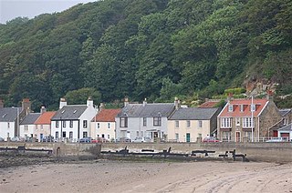
West Wemyss is a village lying on the north shore of the Firth of Forth, in Fife, Scotland. According to the 2007 population estimate, the village has a population of 237. The village was granted burgh of barony status in 1511, bearing the name from the Wemyss family who lived in Wemyss Castle.
Abbeyview is a housing estate in the town of Dunfermline in Fife, Scotland. It is situated in the east of the town, approximately 2 miles from the town centre. Most of the streets in the area are named after Scottish rivers and islands.

Luthrie is a village in the parish of Creich in Fife, Scotland. A small stream shown on maps as Windygates Burn flows through the village and occasionally floods.

Path House, formerly known as Dunnikier House, is a manor house in the Scottish town of Kirkcaldy in the Fife Council Area. It was listed by Historic Environment Scotland in 1971 as a Category A listed building.


