Li Calzi Airport

Last updated
Li Calzi Airport
Summary
Airport type Public use
Owner Peter Huang
Serves Bridgeton, New Jersey
Elevation  AMSL 42 ft / 13 m
Coordinates 39°24′30″N075°14′14″W / 39.40833°N 75.23722°W / 39.40833; -75.23722
Runways
Direction Length Surface
ft m
12/30 2,773 845 Turf
Statistics (2007)
Aircraft operations 300

Li Calzi Airport( FAA LID : N50) was a privately owned, public-use airport located two nautical miles (2.3 mi, 3.7 km) south of the central business district of Bridgeton, a city in Cumberland County, New Jersey, United States. [1]

Federal Aviation Administration United States Government agency dedicated to civil aviation matters

The Federal Aviation Administration (FAA) is a governmental body of the United States with powers to regulate all aspects of civil aviation in that nation as well as over its surrounding international waters. Its powers include the construction and operation of airports, air traffic management, the certification of personnel and aircraft, and the protection of U.S. assets during the launch or re-entry of commercial space vehicles. Powers over neighboring international waters were delegated to the FAA by authority of the International Civil Aviation Organization.

A location identifier is a symbolic representation for the name and the location of an airport, navigation aid, or weather station, and is used for manned air traffic control facilities in air traffic control, telecommunications, computer programming, weather reports, and related services.

Airport location where aircraft take off and land

An airport is an aerodrome with extended facilities, mostly for commercial air transport. Airports often have facilities to store and maintain aircraft, and a control tower. An airport consists of a landing area, which comprises an aerially accessible open space including at least one operationally active surface such as a runway for a plane to take off or a helipad, and often includes adjacent utility buildings such as control towers, hangars and terminals. Larger airports may have airport aprons, taxiway bridges, air traffic control centres, passenger facilities such as restaurants and lounges, and emergency services. In some countries, the US in particular, they also typically have one or more fixed-base operators, serving general aviation.

Contents

Facilities and aircraft

Li Calzi Airport covered an area of 30 acres (12 ha) at an elevation of 42 feet (13 m) above mean sea level. It had one runway designated 12/30 with a turf surface measuring 2,773 by 100 feet (845 x 30 m). For the 12-month period ending April 30, 2007, the airport had 300 general aviation aircraft operations, an average of 25 per month. [1]

Elevation Height of a geographic location above a fixed reference point

The elevation of a geographic location is its height above or below a fixed reference point, most commonly a reference geoid, a mathematical model of the Earth's sea level as an equipotential gravitational surface . The term elevation is mainly used when referring to points on the Earth's surface, while altitude or geopotential height is used for points above the surface, such as an aircraft in flight or a spacecraft in orbit, and depth is used for points below the surface.

Runway Area of surface used by aircraft to takeoff from and land on

According to the International Civil Aviation Organization (ICAO), a runway is a "defined rectangular area on a land aerodrome prepared for the landing and takeoff of aircraft". Runways may be a man-made surface or a natural surface.

General aviation civil use of aircraft excluding commercial transportation

General Aviation (GA) represents the 'private transport' and recreational flying component of aviation.

Related Research Articles

Greater Kankakee Airport airport in Illinois, United States of America

Greater Kankakee Airport is a public use airport located three nautical miles (6 km) south of the central business district of Kankakee, a city in Kankakee County, Illinois, United States. It is included in the National Plan of Integrated Airport Systems for 2011–2015, which categorized it as a general aviation facility.

H. L. Sonny Callahan Airport airport in Alabama, United States of America

H. L. Sonny Callahan Airport is a public-use airport located three nautical miles southeast of the central business district of Fairhope, a city in Baldwin County, Alabama, United States. It is owned by the Fairhope Airport Authority.

Palatka Municipal Airport airport in Florida, United States of America

Palatka Municipal Airport, also known as Lieutenant Kay Larkin Field, is a city-owned, public-use airport located two nautical miles (4 km) northwest of the central business district of Palatka, a city in Putnam County, Florida, United States. It is included in the National Plan of Integrated Airport Systems for 2011–2015, which categorized it as a general aviation facility.

Sylacauga Municipal Airport airport in Alabama, United States of America

Sylacauga Municipal Airport, also known as Merkel Field, is a city-owned public-use airport located three nautical miles west of the central business district of Sylacauga, a city in Talladega County, Alabama, United States. It is included in the FAA's National Plan of Integrated Airport Systems for 2011–2015, which categorized it as a general aviation facility.

Jeremiah Denton Airport airport in Alabama, United States of America

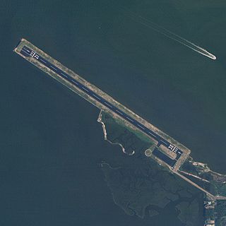
Jeremiah Denton Airport, formerly Dauphin Island Airport, is a county-owned public-use airport in Mobile County, Alabama, United States. It is just northwest of the central business district of Dauphin Island, a town located on a barrier island. The airport is on Mobile Bay, west of the Aloe Bay Channel.

North Pickens Airport airport in Alabama, United States of America

North Pickens Airport is a county-owned public-use airport in Pickens County, Alabama, United States. It is located one nautical mile north of the central business district of Reform, Alabama. The airport is included in the FAA's National Plan of Integrated Airport Systems for 2011–2015, which categorized it as a general aviation facility.

Ardmore Airport (Alabama) airport in Alabama, United States of America

Ardmore Airport is a privately owned, public-use airport located two nautical miles southwest of the central business district of Ardmore, a city in Limestone County, Alabama, United States.

Kroelinger Airport is a privately owned, public-use airport in Cumberland County, New Jersey, United States. It is located three nautical miles north of the central business district of Vineland.

N50 may refer to :

Tri-County Airport is a public-use airport located six nautical miles northeast of the central business district of the city of Bonifay in Holmes County, Florida, United States. The airport is publicly owned.

Tok Junction Airport airport in Alaska, United States of America

Tok Junction Airport is a state-owned public-use airport located one nautical mile east of the central business district of Tok, in the Southeast Fairbanks Census Area of the U.S. state of Alaska.

St. Charles Airport was a privately owned, public use airport located four nautical miles (7.41 km) north of the central business district of the City of St. Charles in St. Charles County, Missouri, United States. According to the FAA's National Plan of Integrated Airport Systems for 2007–2011, it was categorized as a reliever airport. The airport closed on June 30, 2010.

Humboldt Municipal Airport (Iowa) airport in Iowa, United States of America

Humboldt Municipal Airport is a city-owned public-use airport located one nautical mile (1.85 km) west of the central business district of Humboldt, a city in Humboldt County, Iowa, United States. According to the FAA's National Plan of Integrated Airport Systems for 2009–2013, it is classified as a general aviation airport.

Goheen Airport airport in Washington, United States of America

Goheen Airport is a privately owned, public use airport located three nautical miles (6 km) northwest of the central business district of Battle Ground, a city in Clark County, Washington, United States.

Franklin Field is a county-owned public-use airport in Bullock County, Alabama, United States. It is located five nautical miles west of the central business district of Union Springs, Alabama. It is included in the FAA's National Plan of Integrated Airport Systems for 2011–2015, which categorized it as a general aviation facility.

Grimes Airport airport in Pennsylvania, United States of America

Grimes Airport is a privately owned public-use airport located two nautical miles east of the central business district of Bethel, in Berks County, Pennsylvania, United States.

Austin Executive Airport airport in Texas, United States of America

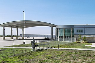
Austin Executive Airport is a public-use airport located in unincorporated Travis County, 12 mi (19 km) northeast of the central business district of Austin, and immediately southeast of Pflugerville. It was known as Bird's Nest Airport prior to 2011.

Gold King Creek Airport airport in Alaska, United States of America

Gold King Creek Airport is a public-use airport located at 64°11′53″N147°55′43″W. It is 39 nautical miles southeast of Fairbanks, Alaska, and is owned by the State of Alaska DOT&PF.

Cherry Ridge Airport airport in Pennsylvania, United States of America

Cherry Ridge Airport is a privately owned, public use airport located three nautical miles (6 km) south of the central business district of Honesdale, a borough in Wayne County, Pennsylvania, United States. This airport was included in the National Plan of Integrated Airport Systems for 2009–2013, which categorized it as a general aviation facility.

Kentland Municipal Airport airport in Indiana, United States of America

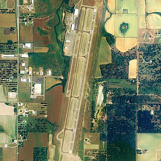
Kentland Municipal Airport is a public use airport located one nautical mile (2 km) southeast of the central business district of Kentland, in Newton County, Indiana, United States. It is owned by the Kentland Board of Aviation Commissioners. This airport included in the National Plan of Integrated Airport Systems for 2011–2015, which categorized it as a general aviation facility.

References

  1. 1 2 3 "N50 - Li Calzi Airport - FAA information effective 30 June 2011". FAA data republished by AirNav. Archived from the original on 21 July 2011.
The National Map

The National Map is a collaborative effort of the United States Geological Survey (USGS) and other federal, state, and local agencies to improve and deliver topographic information for the United States. The purpose of the effort is to provide "...a seamless, continuously maintained set of public domain geographic base information that will serve as a foundation for integrating, sharing, and using other data easily and consistently".