
The Fraser Valley Regional District (FVRD) is a regional district in British Columbia, Canada. Its headquarters are in the city of Chilliwack. The FVRD covers an area of 13,361.74 km² (5,159 sq mi). It was created by an amalgamation of the Fraser-Cheam Regional District and Central Fraser Valley Regional District and the portion of the Dewdney-Alouette Regional District from and including the District of Mission eastwards.

Canim Beach Provincial Park is a provincial park in British Columbia, Canada, located at the southwest end of Canim Lake in the Interlakes District of the South Cariboo region, adjacent to the Secwepemc Indian reserve community of Canim Lake, British Columbia just northeast of 100 Mile House. The park was established by Order-in-Council in 1956 and expanded by later legislation in 2000 and 2004 to total a current approximate of 8.2 hectares.
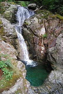
Davis Lake Provincial Park is a provincial park in British Columbia, Canada. It is located east of the southern end of Stave Lake, northeast of Mission, British Columbia. The park's area is c. 185 acres (0.75 km2). There are campgrounds and beaches at the south end of the lake, and the water is warm enough to allow swimming; access is walk-in only. The park features prime bird habitat and a relatively untouched stand of old growth Western Hemlock, as well as a relatively close-up view of Mount Robie Reid.
Mehatl Creek Provincial Park is a provincial park in British Columbia, Canada, located in the central Lillooet Ranges to the west of Boston Bar.
Kwikwasut'inuxw Haxwa'mis, formerly the Kwicksutaineuk-ah-kwa-mish First Nation is a First Nations band government based on northern Vancouver Island in British Columbia, Canada, in the Queen Charlotte Strait region. It is a member of the Musgamagw Tsawataineuk Tribal Council, along with the ‘Namgis First Nation and the Tsawataineuk First Nation. The Kwikwasut'inuxw and Haxwa'mis are two of the many subgroups of the peoples known as Kwakwaka'wakw, which means "speakers of Kwak'wala", their language, and were combined into one band by the Department of Indian and Northern Affairs.
The Williams Lake Indian Band is a First Nations government of the Secwepemc (Shuswap) Nation, located in the Cariboo region of the Central Interior region of the Canadian province of British Columbia, at the city of Williams Lake. It was created when the government of the then-Colony of British Columbia established an Indian Reserve system in the 1860s. It is a member government of the Northern Shuswap Tribal Council. Its main Indian Reserve is Williams Lake Indian Reserve No. 1, a.k.a. "Sugarcane" or "The Cane" or "SCB".
The Alkali Lake Indian Band, also known as the Esketemc First Nation, is a First Nations government of the Secwepemc (Shuswap) people, located at Alkali Lake in the Cariboo region of the Central Interior of the Canadian province of British Columbia. It was created when the government of the then-Colony of British Columbia established an Indian Reserve system in the 1860s. It is one of three Secwepemc bands that is not a member of either the Shuswap Nation Tribal Council or the Northern Shuswap Tribal Council.
The Tl'etinqox-t'in Government Office is a First Nations government located in the Chilcotin District in the western Central Interior region of the Canadian province of British Columbia. Governing a reserve communities near Alexis Creek known as Anaham Reserve First Nations or Anaham, it is a member of the Tsilhqot'in Tribal Council aka known as the Tsilhqot'in National Government. The main reserve is officially known as Anahim's Flat No. 1, and is more commonly as Anaham. Other reserves are Anahim's Meadow No. 2 and 2A, and Anahim Indian Reserves Nos. 3 through 18. Anaham, or Anahim and Alexis were chiefs of the Tsilhqot'in during the Chilcotin War of 1864, although they and their people did not take part in the hostilities.
Huntingdon is a community within Abbotsford, British Columbia, Canada. It is located immediately north of the Canada–US border, and is the location of the Sumas-Huntingdon Border Crossing. The main road through the community is Highway 11. The name of the community is also the present name of the border crossing connecting to Sumas, Washington.
Vedder Mountain is located in the Fraser Valley of British Columbia, Canada, between the village of Yarrow and the village of Cultus Lake. The mountain stands 924 m high and is tree covered to its summit with some open areas. A hiking trail crosses the mountain. Old logging roads are also present. Catherwood Logging rail logged the hill in the 1930s—both east and west sides were cut with rails coming from Vedder Crossing.
Brandywine Creek, also formerly known as the Long John River after a local prospector and trapper, is a tributary of the Cheakamus River in the Pacific Ranges of the Coast Mountains in British Columbia, Canada, entering that stream via Daisy Lake, just below Brandywine Falls. The creek is about 14 km in length and originates on the south slope of Brandywine Mountain in Brandywine Meadows, at the southern end of the Powder Mountain Icefield and is the next basin immediately southwest of that of the Callaghan Valley, the site of the Nordic events facility for the 2010 Olympics. The creek's valley has been partially logged. An unnamed hot spring lies in its upper reaches, near Mount Fee.

The Katzie First Nation or Katzie Nation is the band government of the Katzie people of the Lower Fraser Valley region of British Columbia, Canada.
The Tahltan First Nation, also known as the Tahltan Indian Band, is a band government of the Tahltan people. Their main community and reserves are located at Telegraph Creek, British Columbia. Their language is the Tahltan language, which is an Athabaskan language also known as Nahanni, is closely related to Kaska and Dunneza. Their Indian and Northern Affairs Canada band number is 682. The Tahltan First Nation is joined with the Iskut First Nation in a combined tribal council-type organization known as the Tahltan Nation.
The Leq' a: mel First Nation, formerly known as the Lakahahmen First Nation, is a First Nations band government whose community and offices are located in the area near Deroche, British Columbia, Canada, about 12 kilometres east of the District of Mission. They are a member government of the Sto:lo Nation tribal council, which is one of two tribal councils of the Sto:lo.
South Chilcotin Mountains Provincial Park is a provincial park in British Columbia, Canada, located northwest of Lillooet, British Columbia. The park, which is 56,796 ha. in size, was established in 2010. It was created out of a portion of the Spruce Lake Protected Area.
Rose Lake is an unincorporated community on the Yellowhead Highway in the Bulkley Valley region of northwestern British Columbia, Canada. Its name is derived from the nearby waterbody Rose Lake. The community and the lake are along the northern mainline of the Canadian National Railway just northeast of Bulkley Lake.
Atchelitz is a rural community within the City of Chilliwack in the Eastern Fraser Valley region of British Columbia, Canada. It is located southwest of the city core, to the north of the Vedder Canal.


