
This is a list of locations in Jerusalem sometimes described by the term East Jerusalem :
This is a list of locations in Jerusalem sometimes described by the term East Jerusalem :
The following locations were included within the borders of the Jordanian municipality in the eastern part of the city between 1949 and 1967:
The following locations were included within the borders of the Israeli municipality after its expansion following the 1967 Six-Day War, formalised in the 1980 Israeli Jerusalem Law:

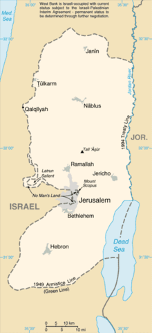
East Jerusalem is the sector of Jerusalem that was held by Jordan after the 1948 Arab–Israeli War, as opposed to the western sector of the city, West Jerusalem, which was held by Israel. Under international law, East Jerusalem is considered a part of the West Bank and, therefore, of the Palestinian territories. A number of states recognize East Jerusalem as the capital of the State of Palestine, whereas other states assert that East Jerusalem "will be the capital of Palestine", while referring to it as "an occupied territory".

Giv'at Ze'ev is an urban Israeli settlement in the West Bank, five kilometers northwest of Jerusalem. The settlement was founded in 1977 on the site of the abandoned Jordanian military camp, adjacent to the site of ancient Gibeon. While it lies within the borders of the Matte Binyamin Regional Council, it is a separate municipal entity. In 2021 it had a population of 20,034.

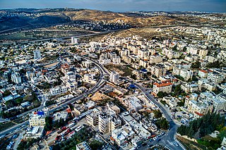
Beit Sahour or Beit Sahur is a Palestinian town east of Bethlehem, in the Bethlehem Governorate of the State of Palestine. The city is under the administration of the Palestinian National Authority. The population was of 13,281 in 2017, consisting of approximately 80% Christians and 20% Muslims.

Har Gilo is an Israeli settlement in the West Bank, organized as a community settlement, located about 2 kilometers west of the Palestinian city of Bethlehem and 5 kilometers south of Jerusalem, in the northern Judean hills.
The Green Line, (pre-)1967 border, or 1949 Armistice border is the demarcation line set out in the 1949 Armistice Agreements between the armies of Israel and those of its neighbors after the 1948 Arab–Israeli War. It served as the de facto borders of the State of Israel from 1949 until the Six-Day War in 1967, and continues to represent Israel’s internationally recognized borders with the two Palestinian territories: the West Bank and the Gaza Strip.

The Jewish Quarter is one of the four traditional quarters of the Old City of Jerusalem. The area lies in the southwestern sector of the walled city, and stretches from the Zion Gate in the south, along the Armenian Quarter on the west, up to the Street of the Chain in the north and extends to the Western Wall and the Temple Mount in the east. In the early 20th century the Jewish population of the quarter reached 19,000.

The Jahalin Bedouin are a Palestinian tribe of Bedouin Arabs who currently live in the eastern Judaean Desert in the West Bank.
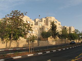
Gilo is an Israeli settlement in south-western East Jerusalem, with a population of 30,000, mostly Jewish inhabitants. Although it is located within the Jerusalem Municipality, it is widely considered a settlement, because as one of the five Ring Neighborhoods built by Israel surrounding Jerusalem, it was built on land in the West Bank that was occupied by and effectively annexed to Israel following the 1967 Six-Day War and 1980 Jerusalem Law.

The Quds Governorate, also Jerusalem Governorate, is one of the 16 governorates of Palestine and located in the central part of the West Bank. The current governor, appointed by the Palestinian National Authority, is Adnan Ghaith since 2018, who succeeded to Adnan al-Husayni, appointed in 2008. The Governorate has two sub-districts: Jerusalem J1, which includes the localities within the territory controlled by the Israeli Jerusalem municipality, and Jerusalem J2, which includes the remaining parts of the Jerusalem Governorate. The district capital of the Governorate is East Jerusalem (al-Quds).
Beit Hanina is an Arab Palestinian neighborhood in East Jerusalem. It is on the road to Ramallah, eight kilometers north of central Jerusalem, at an elevation of 780 meters above sea level. Beit Hanina is bordered by Pisgat Ze'ev and Hizma to the east, Ramot, Ramat Shlomo and Shuafat to the south, Beit Iksa and Nabi Samwil to the west, and Bir Nabala, al-Jib, Kafr Aqab and ar-Ram to the north.
Ad-Dhahiriya is a Palestinian city in the Hebron Governorate of the State of Palestine, 22 km southwest of the city of Hebron in the southern West Bank. According to the Palestinian Central Bureau of Statistics, ad-Dhahiriya had a population of 35,924 in 2017.

Beit Safafa is a Palestinian town along the Green Line, with the vast majority of its territory in East Jerusalem and some northern parts in West Jerusalem.

Beit Ummar is a Palestinian town located eleven kilometers northwest of Hebron in the Hebron Governorate of the State of Palestine. According to the Palestinian Central Bureau of Statistics, in 2017, the town had a population of 16,977 inhabitants. Over 4,800 residents of the town are under the age of 18. Since the Second Intifada, unemployment ranges between 60 and 80 percent due mostly to the inability of residents to work in Israel and a depression in the Palestinian economy. A part of the city straddles Road 60 and due to this, several propositions of house demolition have occurred.
Givat HaMatos is a planned Israeli settlement in East Jerusalem. It encompasses an area of 170 dunams. It is bordered by Talpiot in the north, Gilo in the south, and Beit Safafa in the west. Israel has approved plans to build a new Israeli settlement there.

Al-Kum is a Palestinian village in the southern West Bank, part of the Hebron Governorate and located 13 kilometers west of Hebron. Its municipal borders stretch from the border with Israel in the west to boundaries of the city of Dura in the east. It had a population of 1,464 in the 2017 census by the Palestinian Central Bureau of Statistics.

Musrara is a formerly Palestinian neighborhood in what is now West Jerusalem. It is bordered by the Israeli neighborhoods of Mea Shearim and Beit Yisrael to the north, by the Russian Compound and Kikar Safra to the west, and by the Palestinian Territories’ East Jerusalem to the south and east: East Jerusalem’s Old City to the south and the Palestinian neighborhood of Bab a-Zahara to the east.

Sharafat is a Palestinian Arab neighborhood of East Jerusalem, located within approximately 5 km to the south west of the Old City of Jerusalem. It is situated close to the Palestinian town of Beit Safafa and near the Israeli settlement of Gilo in the southern portion of East Jerusalem.

City Line is the name given to a segment of the Green Line that divided the city of Jerusalem from 1948 to 1967. It was 7 km in length, and constituted a temporary boundary line in accordance with Israel's Armistice Agreement with Jordan, which divided the city between East Jerusalem which was part of the Kingdom of Jordan, and West Jerusalem, the capital of the State of Israel. The Old City bordered the City line on the east side, and thus had been part of the "Jordanian Jerusalem". On both sides of the City line fortifications and obstacles were deployed, and different buildings in the city along the line were used as military posts.

The Israeli annexation of East Jerusalem, known to Israelis as the reunification of Jerusalem, refers to the Israeli occupation of East Jerusalem during the 1967 Six-Day War, and its annexation. Jerusalem was envisaged as a separate, international city under the 1947 United Nations partition plan, but it was divided by the 1948 war that followed Israel's declaration of independence. As a result of the 1949 Armistice Agreements, the city's western half came under Israeli control, while its eastern half, containing the famed Old City, fell under Jordanian control. In 1950, Jordan annexed East Jerusalem as part of its larger annexation of the West Bank.