Related Research Articles

Jan Mayen is a Norwegian volcanic island in the Arctic Ocean with no permanent population. It is 55 km (34 mi) long (southwest-northeast) and 373 km2 (144 sq mi) in area, partly covered by glaciers. It has two parts: larger northeast Nord-Jan and smaller Sør-Jan, linked by a 2.5 km (1.6 mi) wide isthmus. It lies 600 km (370 mi) northeast of Iceland, 500 km (310 mi) east of central Greenland, and 900 km (560 mi) northwest of Vesterålen, Norway. The island is mountainous, the highest summit being the Beerenberg volcano in the north. The isthmus is the location of the two largest lakes of the island, Sørlaguna and Nordlaguna. A third lake is called Ullerenglaguna. Jan Mayen was formed by the Jan Mayen hotspot and is defined by geologists as a microcontinent.

Svalbard, previously known as Spitsbergen or Spitzbergen, is a Norwegian archipelago in the Arctic Ocean. North of mainland Europe, it lies about midway between the northern coast of Norway and the North Pole. The islands of the group range from 74° to 81° north latitude, and from 10° to 35° east longitude. The largest island is Spitsbergen, followed in size by Nordaustlandet and Edgeøya. The largest settlement is Longyearbyen on the west coast of Spitsbergen.
Shetland, also called the Shetland Islands and formerly Zetland, is an archipelago in Scotland lying between Orkney, the Faroe Islands, and Norway. It is the northernmost region of the United Kingdom.

The Barents Sea is a marginal sea of the Arctic Ocean, located off the northern coasts of Norway and Russia and divided between Norwegian and Russian territorial waters. It was known earlier among Russians as the Northern Sea, Pomorsky Sea or Murman Sea ; the current name of the sea is after the historical Dutch navigator Willem Barentsz.

Spitsbergen, is the largest and the only permanently populated island of the Svalbard archipelago in northern Norway.

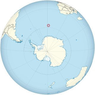
Peter I Island is an uninhabited volcanic island in the Bellingshausen Sea, 450 kilometres (240 nmi) from continental Antarctica. It is claimed as a dependency of Norway and, along with Bouvet Island and Queen Maud Land, composes one of the three Norwegian dependent territories in the Antarctic and Subantarctic. The island measures approximately 11 by 19 kilometres, with an area of 156 km2 (60 sq mi); its highest point is the ultra-prominent, 1,640-metre-tall (5,380 ft) Lars Christensen Peak. Nearly all the island is covered by a glacier, and it is surrounded most of the year by pack ice, making it inaccessible during these times. There is little vertebrate animal life on the island, apart from some seabirds and seals.
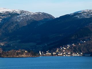
Osterøy is an island municipality in Vestland county, Norway. It is located in the traditional district of Nordhordland. The municipality encompasses most of the island of Osterøy. The administrative centre of Osterøy is the village of Lonevåg in the central part of the island. The largest settlement is the village of Valestrandfossen with 1,219 inhabitants as of 1 January 2016.

Radøy is a former municipality in the Nordhordland district of the old Hordaland county, Norway. The municipality existed from 1964 until its dissolution in 2020 when it was merged into the new municipality of Alver in Vestland county. The municipality included almost all of the island of Radøy plus many small surrounding islands. The administrative centre of the municipality was the village of Manger. Other villages in the municipality included Askeland, Austmarka, Bøvågen, Haugland, Sæbø, and Sletta.
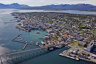
Tromsø is a municipality in Troms og Finnmark county, Norway. The administrative centre of the municipality is the city of Tromsø.
A dependent territory, dependent area, or dependency is a territory that does not possess full political independence or sovereignty as a sovereign state, yet remains politically outside the controlling state's integral area.

Barentsøya, anglicized as Barents Island, is an island in the Svalbard archipelago of Norway, lying between Edgeøya and Spitsbergen. Barents Island has no permanent human inhabitants. Named for the Dutch explorer Willem Barents, it is a part of Søraust-Svalbard Nature Reserve.

Kvitøya is an island in the Svalbard archipelago in the Arctic Ocean, with an area of 682 square kilometres (263 sq mi). It is the easternmost part of the Kingdom of Norway. The closest Russian Arctic possession, Victoria Island, lies only 62 kilometres (39 mi) to the east of Kvitøya.

Øyeren is a lake in the Glomma River watershed, southeast of Lillestrøm. It is located within the municipalities of Enebakk, Skedsmo, Fet, and Rælingen in Akershus county and Spydeberg and Trøgstad municipalities in Østfold county.

Lågøya is an island in Svalbard, Norway. It is situated north west of Nordaustlandet. The area is 103.5 km2. The island has rarely been visited.

The following outline provides an overview of, and topical guide to, the Kingdom of Norway.
Foyn Island, also known as Svend Foyn Island, is the second largest island in the Possession Islands, East Antarctica, lying 6 kilometres (4 mi) south-west of Possession Island. An Adélie penguin rookery covers much of the island, which is often included in the itinerary of Antarctic cruises.
Bouvet Island is an island and dependency of Norway, and declared an uninhabited protected nature reserve. It is a subantarctic volcanic island, situated in the South Atlantic Ocean at the southern end of the Mid-Atlantic Ridge, making it the world's most remote island. It is not part of the southern region covered by the Antarctic Treaty System.
Filla Island is a rocky island about 5.5 kilometres (3.4 mi) long, located in the northern part of the Rauer Islands and being the largest island in the group. It was charted by Norwegian cartographers from air photos taken by the Lars Christensen Expedition (1936–37). They gave the name Filla to a larger island here, presumably for the ragged outline of the feature as shown on the Norwegian chart. In 1952, John Roscoe made a study of this area as revealed in aerial photographs taken by U.S. Navy Operation Highjump (1946–47). He found that what the Norwegians had named Filla was in fact a cluster of small islands. He applied the name Filla Island to the largest of these as described.

Vestland is a county in Norway established on 1 January 2020. The county is located in Western Norway and it is centred around the city of Bergen, Norway's second largest city. The administrative centre of the county is the city of Bergen, where the executive and political leadership is based, but the County Governor is based in Hermansverk. The county is one of two counties in Norway that have Nynorsk as their official written language form.