The Union of South Africa was the historical predecessor to the present-day Republic of South Africa. It came into existence on 31 May 1910 with the unification of the Cape, the Natal, the Transvaal, and the Orange River colonies. It included the territories that were formerly a part of the South African Republic and the Orange Free State.

The Province of the Cape of Good Hope, commonly referred to as the Cape Province and colloquially as The Cape, was a province in the Union of South Africa and subsequently the Republic of South Africa. It encompassed the old Cape Colony, as well as Walvis Bay, and had Cape Town as its capital. In 1994, the Cape Province was divided into the new Eastern Cape, Northern Cape and Western Cape provinces, along with part of the North West.

South Africa is divided into nine provinces. On the eve of the 1994 general election, South Africa's former homelands, also known as Bantustans, were reintegrated, and the four existing provinces were divided into nine. The twelfth, thirteenth and sixteenth amendments to the Constitution of South Africa changed the borders of seven of the provinces.

Andrew Geddes Bain, was a South African geologist, road engineer, palaeontologist and explorer.
The Cabot Trail is a scenic highway on Cape Breton Island in Nova Scotia, Canada. It is a 298 km (185 mi) loop around the northern tip of the island, passing along and through the Cape Breton Highlands and the Cape Breton Highlands National Park.

The Eastern Cape is one of the provinces of South Africa. Its capital is Bhisho, but its two largest cities are East London and Gqeberha.

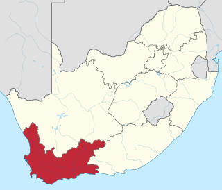
The Western Cape is a province of South Africa, situated on the south-western coast of the country. It is the fourth largest of the nine provinces with an area of 129,449 square kilometres (49,981 sq mi), and the third most populous, with an estimated 7 million inhabitants in 2020. About two-thirds of these inhabitants live in the metropolitan area of Cape Town, which is also the provincial capital. The Western Cape was created in 1994 from part of the former Cape Province. The two largest cities are Cape Town and George.

The N1 is a national route in South Africa that runs from Cape Town through Bloemfontein, Johannesburg, Pretoria and Polokwane to Beit Bridge on the border with Zimbabwe. It forms the first section of the famed Cape to Cairo Road.

The Swartberg mountains are a mountain range in the Western Cape province of South Africa. It is composed of two main mountain chains running roughly east–west along the northern edge of the semi-arid Little Karoo. To the north of the range lies the other large semi-arid area in South Africa, the Great Karoo. Most of the Swartberg Mountains are above 2000 m high, making them the tallest mountains in the Western Cape. It is also one of the longest, spanning some 230 km from south of Laingsburg in the west to between Willowmore and Uniondale in the east. Geologically, these mountains are part of the Cape Fold Belt.

Kommetjie is a small town near Cape Town, in the Western Cape province of South Africa. It lies about halfway down the west coast of the Cape Peninsula, at the southern end of the long wide beach that runs northwards towards Chapman's Peak and Noordhoek.

The Langeberg Range is a mountain range in the Western Cape province of South Africa. Its highest peak is Keeromsberg at 2,075 m that lies 15 km northeast of the town of Worcester. Some of the highest peaks of the range are located just to the north of Swellendam, in a subrange known as the Clock Peaks whose highest point is the 1,710 m high Misty Point. Local lore states one can tell the time by means of the shadows cast by the seven summits of the Clock Peaks.

The M3 is an expressway in Cape Town, South Africa, connecting the upper part of the City Bowl to the Southern Suburbs and ending in Tokai. For most of its route it parallels - though further to the south and west - the M4, which was the original road connecting central Cape Town with the settlements to the south.

The South Africa Act 1909 was an Act of the British Parliament which created the Union of South Africa from the British colonies of the Cape of Good Hope, Natal, Orange River Colony, and Transvaal. The Act also made provisions for admitting Rhodesia as a fifth province of the Union in the future, but Rhodesian colonists rejected this option in a referendum held in 1922. The South Africa Act was the third major piece of legislation passed by the Parliament of the United Kingdom with the intent of uniting various British colonies and granting them some degree of autonomy. Earlier, the British North America Act, 1867 had united three colonies and the Commonwealth of Australia Constitution Act, 1900 had united the Australian colonies.
The system of racial segregation in South Africa known as apartheid was implemented and enforced by many acts and other laws. This legislation served to institutionalise racial discrimination and the dominance by white people over people of other races. While the bulk of this legislation was enacted after the election of the National Party government in 1948, it was preceded by discriminatory legislation enacted under earlier British and Afrikaner governments. Apartheid is distinguished from segregation in other countries by the systematic way in which it was formalised in law.

The Western Cape Provincial Parliament (WCPP) is the legislature of the Western Cape province of South Africa. It is located at 7 Wale Street in Cape Town.

The Eastern Cape Provincial Legislature is the primary legislative body of the South African province of Eastern Cape. It is unicameral in its composition, and elects the premier and the provincial cabinet from among the members of the leading party or coalition in the parliament.

The Constitution of the Western Cape is, subject to the Constitution of South Africa, the highest law regulating the structure and powers of the government of the Western Cape province of South Africa. It was enacted by the Western Cape Provincial Legislature in terms of Chapter 6 of the national constitution, and came into force on 16 January 1998. The Western Cape is the only South African province to have adopted a constitution.
The Coloured vote constitutional crisis, also known as the Coloured vote case, was a constitutional crisis that occurred in the Union of South Africa during the 1950s as the result of an attempt by the Nationalist government to remove Coloured voters in the Union's Cape Province from the common voters' rolls. It developed into a dispute between the judiciary and the other branches of government over the power of Parliament to amend an entrenched clause in the South Africa Act and the power of the Appellate Division to overturn the amendment as unconstitutional. The crisis ended when the government enlarged the Senate and altered its method of election, allowing the amendment to be successfully enacted.

The Northern Cape Provincial Legislature is the legislature of the Northern Cape province of South Africa. It is a unicameral body of 30 members elected every five years. The current legislature was elected on 8 May 2019 and has an African National Congress majority of 18 members. It is situated in Kimberley, in a newly built complex to the west of the city centre on the edge of Galeshewe.

Cape independence – also known by the portmanteau CapeXit – is the political movement to make the Western Cape province, and often other regions of the Eastern and Northern Cape provinces, an independent state from the rest of South Africa.