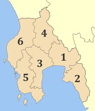
Messenia or Messinia is a regional unit in the southwestern part of the Peloponnese region, in Greece. Until the implementation of the Kallikratis plan on 1 January 2011, Messenia was a prefecture (nomos) covering the same territory. The capital and largest city of Messenia is Kalamata.

Drama is a city and municipality in Macedonia, northeastern Greece. Drama is the capital of the regional unit of Drama which is part of the East Macedonia and Thrace region. The city is the economic center of the municipality, which in turn comprises 60 percent of the regional unit's population. The next largest communities in the municipality are Χiropótamos (2,535), Choristi, Kallífytos (1,627), Kalós Agrós (838), and Koudoúnia (814).

Florina is one of the regional units of Greece. It is part of the region of Western Macedonia, in the geographic region of Macedonia, Greece. Its capital is the town of Florina with a population of around 49.500 (2019)

Chalkidiki, also known as Chalcidice, is a peninsula and regional unit of Greece, part of the region of Central Macedonia, in the geographic region of Macedonia in Northern Greece. The autonomous Mount Athos region constitutes the easternmost part of the peninsula, but not of the regional unit.

Rhodope is one of the regional units of Greece. It is part of the region of East Macedonia and Thrace. Its name is derived from the Rhodope Mountains, which cover the northern part of its territory. Together with the regional units Evros and Xanthi, it forms the geographical region of Western Thrace. The capital of the prefecture is the city of Komotini. The second largest town is Sapes. Most of the Muslims of Thrace, the only officially recognized minority in Greece, are settled in this area, where they form around half of the regional unit's population.

Pyrgos is a city in the northwestern Peloponnese, Greece, capital of the regional unit of Elis and the seat of the Municipality of Pyrgos. The city is located in the middle of a plain, 4 kilometres from the Ionian Sea. The river Alfeios flows into sea about 7 km (4 mi) south of Pyrgos. The population of the town Pyrgos is 25,180, and of the municipality 47,995 (2011). Pyrgos is 16 km (10 mi) west of Olympia, 16 km (10 mi) southeast of Amaliada, 70 km (43 mi) southwest of Patras and 85 km (53 mi) west of Tripoli.

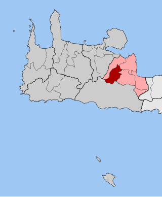
Ierapetra is a Greek city and municipality located on the southeast coast of Crete.

Paralia is a tourist seaside settlement and a former municipality in the eastern part of the Pieria regional unit, Greece. Since the 2011 local government reform it is part of the municipality Katerini, of which it is a municipal unit. The seat of the municipality was in Kallithea. The 2021 census reported a population of 928 for the community of Paralia, and 6,228 for the municipal unit. The municipal unit has an area of 24.344 km2, the community 1.849 km2. Paralia Katerinis actually translated "Beach of Katerini" and is the closest beach to the capital city of Katerini.
Orestiada, is the northeasternmost, northernmost and newest city of Greece and the second largest town of the Evros regional unit of Thrace. Founded by Greek refugees from Edirne after the Treaty of Lausanne when the population exchange occurred between Turkey and Greece, in which the river Evros became the new border between the two countries. The population is around 20,000.
Ioannina is one of the regional units of Greece, located in the northwestern part of the country.

Rethymno is one of the four regional units of Crete, Greece. Its capital is the city of Rethymno. Today its main income is tourism. The countryside is also based economically on agriculture and herding.

Pikrolimni is a former municipality in the Kilkis regional unit, Greece. Since the Kallikratis Plan for local government reform was implemented in 2011, Pikrolimni is administrated as part and constitutes a municipal unit of the municipality of Kilkis. The municipal unit has an area of 164.06 km2, and its population in the 2021 census was 4,297, down from 7,395 in 2001. The seat of the municipality was Mikrokampos.

Gonnoi is a former municipality in the Larissa regional unit, Thessaly, Greece. Since the 2011 local government reform it is part of the municipality Tempi, of which it is a municipal unit. Population 2,462 (2011). The municipal unit has an area of 113.333 km2. The municipality was created under the Kapodistrias Law in 1997 out of the former communes of Gonnoi, Kallipefki, Itea and Elaia. About 2 kilometres (1.2 mi) southeast of the town lies the site of the ancient city of Gonnus, after which the present town is named.
Melivoia is a town and a former municipality in the Larissa regional unit, Thessaly, Greece. Since the 2011 local government reform it is part of the municipality Agia, of which it is a municipal unit. Population 2,195 (2011). The municipal unit has an area of 197.633 km2. The seat of the municipality was in Kato Sotiritsa. Melivoia is located east of Larissa, the capital of the regional unit and Thessaly, and a few kilometers north of Agia. The municipal unit stretches along the Aegean Sea coast, at the foot of Mount Ossa. It was named after the ancient city Meliboea. The municipal unit borders on Magnesia to the southeast.

Oichalia Greek: Οιχαλία, before 1981: Νεοχώρι - Neochori) is a town and a former municipality in the Trikala regional unit, Thessaly, Greece. Since the 2011 local government reform it is part of the municipality Farkadona, of which it is a municipal unit. The municipal unit has an area of 85.628 km2. In 2011 the population of the municipality was 4,781, the population of the town proper was 2,357. Oichalia is located 8 km west of Farkadona centre, and 20 km east of the city of Trikala. It is situated on the edge of the Thessalian Plain near the ancient city of Oechalia. The Greek National Road 6 passes south of Oichalia.
Fres is a village and former municipality in the Chania regional unit, Crete, Greece. Since the 2011 local government reform, it is part of the municipality Apokoronas, of which it is a municipal unit. The municipal unit has an area of 53.819 km2 (20.780 sq mi). Fres has a population of 326 (2011). The city has a large main square surrounded by several cafés where the locals in the village meet and socialize. An archway in Fres leads through to the upper village and to the chapel of Our Lady of the Two Rocks.
Mesochora is a mountain village in the municipal unit of Pindos in the southwestern part of the Trikala regional unit, Greece. It is located in the Athamanika mountains, on the upper course of the river Acheloos, about 800 m above sea level. It is situated 40 km west of the city of Trikala. It is located by the Greek National Road 30. In 2011 Mesochora had a population of 141 for the settlement, and 143 for the community, including the small villages Exochi and Spitia. It became a part of the municipality of Pindos in 1997 under the Capodistrian Plan.
Messini is a municipal unit and the seat town (edra) of the municipality (dimos) of Messini within the regional unit of Messenia in the region (perifereia) of Peloponnese, one of 13 regions into which Greece has been divided. Before 2011 the same hierarchy prevailed, according to Law 2539 of 1997, the Kapodistrias Plan, except that Messenia was a nomos and the Municipal unit was a locality. The dimos existed under both laws, but not with the same constituents.

Attica is an administrative region of Greece, that encompasses the entire Athens metropolitan area, the core city of which is the country's capital and largest city, Athens. The region is coextensive with the former Attica Prefecture of Central Greece and covers a greater area than the historical region of Attica.