
Canals or artificial waterways are waterways or engineered channels built for drainage management or for conveyancing water transport vehicles. They carry free, calm surface flow under atmospheric pressure, and can be thought of as artificial rivers.

The Erie Canal is a historic canal in upstate New York that runs east–west between the Hudson River and Lake Erie. Completed in 1825, the canal was the first navigable waterway connecting the Atlantic Ocean to the Great Lakes, vastly reducing the costs of transporting people and goods across the Appalachians. In effect, the canal accelerated the settlement of the Great Lakes region, the westward expansion of the United States, and the economic ascendancy of New York State. It has been called "The Nation's First Superhighway."

British Waterways, often shortened to BW, was a statutory corporation wholly owned by the government of the United Kingdom. It served as the navigation authority for the majority of canals and a number of rivers and docks in England, Scotland and Wales.

The Intracoastal Waterway (ICW) is a 3,000-mile (4,800 km) inland waterway along the Atlantic and Gulf of Mexico coasts of the United States, running from Massachusetts southward along the Atlantic Seaboard and around the southern tip of Florida, then following the Gulf Coast to Brownsville, Texas. Some sections of the waterway consist of natural inlets, saltwater rivers, bays, and sounds, while others are artificial canals. It provides a navigable route along its length without many of the hazards of travel on the open sea.

The New York–New Jersey Harbor Estuary, also known as the Hudson-Raritan Estuary, is in the northeastern states of New Jersey and New York on the East Coast of the United States. The system of waterways of the Port of New York and New Jersey forms one of the most intricate natural harbors in the world and one of the busiest ports of the United States. The harbor opens onto the New York Bight in the Atlantic Ocean to the southeast and Long Island Sound to the northeast.

Delaware Bay is the estuary outlet of the Delaware River on the northeast seaboard of the United States, lying between the states of Delaware and New Jersey. It is approximately 782 square miles (2,030 km2) in area, the bay's freshwater mixes for many miles with the saltwater of the Atlantic Ocean.

The United States Lighthouse Service, also known as the Bureau of Lighthouses, was the agency of the United States Government and the general lighthouse authority for the United States from the time of its creation in 1910 as the successor of the United States Lighthouse Board until 1939 when it was merged into the United States Coast Guard. It was responsible for the upkeep and maintenance of all lighthouses and lightvessels in the United States.

Water police, also called bay constables, coastal police, harbor patrols, marine/maritime police/patrol, nautical patrols, port police, or river police are a specialty law enforcement portion of a larger police organization, who patrol in water craft. Their patrol areas may include coastal tidal waters, rivers, estuaries, harbors, lakes, canals or a combination of these.

The New York State Canal System is a successor to the Erie Canal and other canals within New York. Currently, the 525-mile (845 km) system is composed of the Erie Canal, the Oswego Canal, the Cayuga–Seneca Canal, and the Champlain Canal. In 2014 the system was listed as a national historic district on the National Register of Historic Places in its entirety, and in 2016 it was designated a National Historic Landmark.

The Port of New York and New Jersey is the port district of the New York-Newark metropolitan area, encompassing the region within approximately a 25-mile (40 km) radius of the Statue of Liberty National Monument.

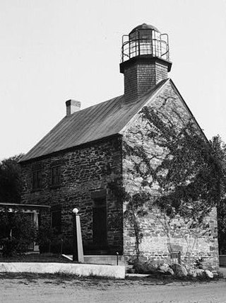
The Stony Point Light is the oldest lighthouse on the Hudson River. It is located at the Stony Point Battlefield in Stony Point, New York.

The Steamboat Inspection Service was a United States agency created in 1871 to safeguard lives and property at sea. It merged with the Bureau of Navigation in 1932 to form the Bureau of Navigation and Steamboat Inspection, which in 1936 was reorganized into the Bureau of Marine Inspection and Navigation. The Bureau of Marine Inspection and Navigation's responsibilities were transferred temporarily to the United States Coast Guard in 1942. The Bureau was abolished in 1946, when its functions were transferred permanently to the Coast Guard.

Buffalo (Main) Light is a lighthouse at the mouth of Buffalo River/Erie Canal, directly across from the Erie Basin Marina in Buffalo, New York.

United States Naval Districts is a system created by the United States Navy to organize military facilities, numbered sequentially by geographic region, for the operational and administrative control of naval bases and shore commands in the United States and around the world. Established in 1903, naval districts became the foundational system for organizing U.S. naval forces ashore during the 20th century. The term "Naval" forces includes United States Marine Corps and current United States Coast Guard units.
Selkirk Lighthouse is located at mouth of the Salmon River in New York. It is one of only four lighthouses in the United States that retains its original bird-cage lantern.

The Port of Albany–Rensselaer, widely known as the Port of Albany, is a port of entry in the United States with facilities on both sides of the Hudson River in Albany and Rensselaer, New York. Private and public port facilities have existed in both cities since the 17th century, with an increase in shipping after the Albany Basin and Erie Canal were built with public funds in 1825.
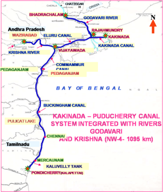
National Waterway 4 (NW-4) is a 1,095 kilometres (680 mi) long waterway in India. It has been declared as an Indian National Waterway and is currently under development. It connects the Indian states of Telangana, Andhra Pradesh, Tamil Nadu, and the union territory of Puducherry. The NW-4 runs along the Coromandal Coast through Kakinada, Eluru, Commanur, Buckingham Canals and also through part of Krishna and Godavari rivers in South India. It was declared a National Waterway on 24 November 2008 under the Provisions of National Waterways Bill, 2006. It is being developed by the Inland Waterways Authority of India (IWAI), and was scheduled for completion by 2013. The National Waterways Act, 2016 has extended the length of NW-4 from 1,095 km (680 mi) to 2,890 km (1,800 mi) by connecting the Krishna and Godavari Rivers. The Project would be undertaken in 3 phases with first phase beginning in October, 2017 and to be completed by June, 2019 intent { //Hacked //By //Yy

The Port of Salem is a shallow-draft port in the vicinity of the Salem River Cut-Off on the Salem River in Salem, New Jersey in the United States about 2 miles (3.2 km) east of the Delaware River and about 54 miles (87 km) from the Atlantic Ocean. It was re-designated a port of entry in 1984 and became a foreign trade zone (FTZ) in 1987. Transloading operations include the handling of a variety of bulk cargo, notably of construction aggregate, break bulk cargo, and containers for clothing, fishing apparel, agricultural produce, and other consumer goods, and has at times involved lighterage. It is operated under the auspices of the South Jersey Port Corporation. The port is envisioned as being a component of the supply chain for the development of windpower in the Atlantic Ocean off the coast of New Jersey.