This article lists proposed canals, that have not yet been built.

This article lists proposed canals, that have not yet been built.


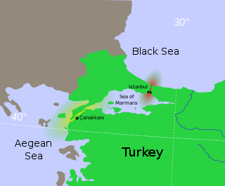
The Bosporus or Bosphorus Strait is a natural strait and an internationally significant waterway located in Istanbul, Turkey. The Bosporus connects the Black Sea to the Sea of Marmara and forms one of the continental boundaries between Asia and Europe. It also divides Turkey by separating Anatolia from Thrace. It is the world's narrowest strait used for international navigation.

Canals or artificial waterways are waterways or engineered channels built for drainage management or for conveyancing water transport vehicles. They carry free, calm surface flow under atmospheric pressure, and can be thought of as artificial rivers.

The (Montreux) Convention regarding the Regime of the Straits, often known simply as the Montreux Convention, is an international agreement governing the Bosporus and Dardanelles Straits in Turkey. Signed on 20 July 1936 at the Montreux Palace in Switzerland, it went into effect on 9 November 1936, addressing the long running Straits Question over who should control the strategically vital link between the Black and Mediterranean seas.

The Suez Canal is an artificial sea-level waterway in Egypt, connecting the Mediterranean Sea to the Red Sea through the Isthmus of Suez and dividing Africa and Asia. The 193.30-kilometre-long (120.11 mi) canal is a key trade route between Europe and Asia.

An isthmus is a narrow piece of land connecting two larger areas across an expanse of water by which they are otherwise separated. A tombolo is an isthmus that consists of a spit or bar, and a strait is the sea counterpart of an isthmus, a narrow stretch of sea between two landmasses that connects two larger bodies of water.

The Aire and Calder Navigation is the canalised section of the Rivers Aire and Calder in West Yorkshire, England. The first improvements to the rivers above Knottingley were completed in 1704 when the Aire was made navigable to Leeds and the Calder to Wakefield, by the construction of 16 locks. Lock sizes were increased several times, as was the depth of water, to enable larger boats to use the system. The Aire below Haddlesey was bypassed by the opening of the Selby Canal in 1778. A canal from Knottingley to the new docks and new town at Goole provided a much shorter route to the River Ouse from 1826. The New Junction Canal was constructed in 1905, to link the system to the River Don Navigation, by then part of the Sheffield and South Yorkshire Navigation.

The Lake Washington Ship Canal, which runs through the city of Seattle, connects the fresh water body of Lake Washington with the salt water inland sea of Puget Sound. The Hiram M. Chittenden Locks accommodate the approximately 20-foot (6.1 m) difference in water level between Lake Washington and the sound. The canal runs east–west and connects Union Bay, the Montlake Cut, Portage Bay, Lake Union, the Fremont Cut, Salmon Bay, and Shilshole Bay, which is part of the sound.

The Chesapeake & Delaware Canal is a 14-mile (22.5 km)-long, 450-foot (137.2 m)-wide and 35-foot (10.7 m)-deep ship canal that connects the Delaware River with the Chesapeake Bay in the states of Delaware and Maryland in the United States.

The Danube–Black Sea Canal is a navigable canal in Romania, which runs from Cernavodă on the Danube river, via two branches, to Constanța and Năvodari on the Black Sea. Administered from Agigea, it is an important part of the waterway link between the North Sea and the Black Sea via the Rhine–Main–Danube Canal. The main branch of the canal, with a length of 64.4 km (40.0 mi), which connects the Port of Cernavodă with the Port of Constanța, was built in 1976–1984, while the northern branch, known as the Poarta Albă–Midia Năvodari Canal, with a length of 31.2 km (19.4 mi), connecting Poarta Albă and the Port of Midia, was built between 1983 and 1987.

Lenin Volga–Don Shipping Canal is a ship canal in Russia. It connects the Volga and the Don at their closest points. Opened in 1952, its length is 101 km (63 mi), 45 km (28 mi) of which is through rivers and reservoirs.

Maroochydore is a coastal city in the Sunshine Coast Region, Queensland, Australia.
The Arabian Canal is a proposed mega-infrastructure project located in the United Arab Emirates that aims to create a man-made waterway connecting the Persian Gulf to the Arabian Sea.

The Turkish Straits are two internationally significant waterways in northwestern Turkey. The Straits create a series of international passages that connect the Aegean and Mediterranean seas to the Black Sea. They consist of the Dardanelles and the Bosphorus. The straits are on opposite ends of the Sea of Marmara. The straits and the Sea of Marmara are part of the sovereign sea territory of Turkey and are treated as Turkish internal waters.

The Northern river reversal or Siberian river reversal was an ambitious project to divert the flow of the Northern rivers in the Soviet Union, which "uselessly" drain into the Arctic Ocean, southwards towards the populated agricultural areas of Central Asia, which lack water.

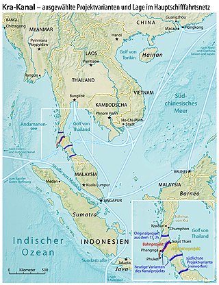
The Thai Canal, also known as Kra Canal or Kra Isthmus Canal, is any of several proposals for a canal that would connect the Gulf of Thailand with the Andaman Sea across the Kra Isthmus in southern Thailand. Such a canal would significantly reduce travel times through heavily-navigated trade routes.
The Grand Korean Waterway, officially known as the Pan Korea Grand Waterway, was a proposed 540-kilometer-long (340 mi) canal connecting Seoul and Busan, South Korea's two largest cities. The canal would run diagonally across the country connecting the Han River, which flows through Seoul into the Yellow Sea, to the Nakdong River, which flows through Busan into the Korea Strait. The proposed canal would traverse difficult mountainous terrain.

The Eurasia Canal is a proposed 700-kilometre-long (430 mi) canal connecting the Caspian Sea to the Black Sea along the Kuma-Manych Depression. Currently, a chain of lakes and reservoirs and the shallow irrigation Kuma–Manych Canal are found along this route. If completed the canal would also link several landlocked countries in Asia with the open seas through the Bosphorus.

The Caspian Sea is the world's largest inland body of water, often described as the world's largest lake and sometimes referred to as a full-fledged sea. An endorheic basin, it lies between Europe and Asia: east of the Caucasus, west of the broad steppe of Central Asia, south of the fertile plains of Southern Russia in Eastern Europe, and north of the mountainous Iranian Plateau. It covers a surface area of 371,000 km2 (143,000 sq mi), an area approximately equal to that of Japan, with a volume of 78,200 km3 (19,000 cu mi). It has a salinity of approximately 1.2%, about a third of the salinity of average seawater. It is bounded by Kazakhstan to the northeast, Russia to the northwest, Azerbaijan to the southwest, Iran to the south, and Turkmenistan to the southeast.

The Danube is the second-longest river in Europe, after the Volga in Russia. It flows through Central and Southeastern Europe, from the Black Forest south into the Black Sea. A large and historically important river, it was once a frontier of the Roman Empire. In the 21st century, it connects ten European countries, running through their territories or marking a border. Originating in Germany, the Danube flows southeast for 2,850 km (1,770 mi), passing through or bordering Austria, Slovakia, Hungary, Croatia, Serbia, Romania, Bulgaria, Moldova, and Ukraine. Among the many cities on the river are four national capitals: Vienna, Bratislava, Budapest, and Belgrade. Its drainage basin amounts to 817,000 km² and extends into nine more countries.

The Istanbul Canal is a project for an artificial sea-level waterway planned by Turkey in East Thrace, connecting the Black Sea to the Sea of Marmara, and thus to the Aegean and Mediterranean seas. The Istanbul Canal would bisect the current European side of Istanbul and thus form an island between Asia and Europe. The new waterway would bypass the current Bosporus.