This is a list of provincial parks in Southwestern Ontario . These provincial parks are maintained by Ontario Parks. For a list of other provincial parks in Ontario, see the List of provincial parks in Ontario.
| Name | Established | Commons category | Picture | Coordinates |
|---|---|---|---|---|
| Clear Creek Forest Provincial Park | 2014 | 42°28′20″N81°43′24″W / 42.472314°N 81.723261°W | ||
| Rondeau Provincial Park | 1894 | Rondeau Provincial Park |  | 42°17′00″N81°52′00″W / 42.2833°N 81.8667°W |
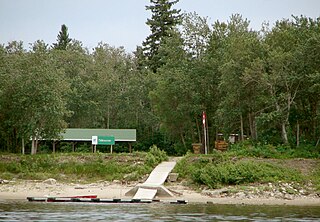
| Wheatley Provincial Park | 1971 | Wheatley Provincial Park |  | 42°05′24″N82°26′50″W / 42.09°N 82.4472°W |
| Name | Established | Coordinates |
|---|---|---|
| John E. Pearce Provincial Park | 1957 | 42°36′29″N81°26′48″W / 42.608055555556°N 81.446666666667°W |
| Port Bruce Provincial Park | 1974 | 42°39′18″N81°00′48″W / 42.655°N 81.013333333333°W |
| Port Burwell Provincial Park (formerly Iroquois Beach Provincial Park 1971-1986) | 1971 | 42°38′53″N80°48′58″W / 42.648055555556°N 80.816111111111°W |
| Name | Established | Commons category | Picture | Coordinates |
|---|---|---|---|---|
| James N. Allan Provincial Park | 1989 | 42°50′58″N79°39′48″W / 42.84948°N 79.663466°W | ||
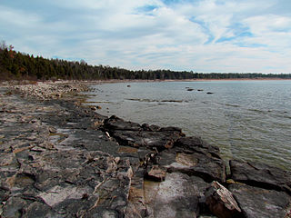
| Rock Point Provincial Park | 1957 | Rock Point Provincial Park |  | 42°50′54″N79°33′09″W / 42.8482°N 79.5525°W |
| Selkirk Provincial Park | 1967 | 42°48′50″N79°57′32″W / 42.813888888889°N 79.958888888889°W |
| Name | Established | Commons category | Picture | Coordinates |
|---|---|---|---|---|
| The Pinery Provincial Park | 1957 | Pinery Provincial Park |  | 43°15′36″N81°49′40″W / 43.26°N 81.8278°W |
| Name | Established | Coordinates |
|---|---|---|
| Komoka Provincial Park | 1989 | 42°57′00″N81°23′51″W / 42.95°N 81.3975°W |
| Name | Established | Commons category | Picture | Coordinates |
|---|---|---|---|---|
| Long Point Provincial Park | 1921 | Long Point Provincial Park |  | 42°34′48″N80°23′06″W / 42.58°N 80.385°W |
| Turkey Point Provincial Park | 1959 |  | 42°42′17″N80°20′00″W / 42.7047°N 80.3333°W |
| Name | Established | Coordinates |
|---|---|---|
| Trillium Woods Provincial Park | 1969 | 43°03′50″N80°46′40″W / 43.06377°N 80.77787°W |
Ontario Parks is the Ontario government agency in Ontario, Canada, that protects significant natural and cultural resources in a system of parks and protected areas that is sustainable and provides opportunities for inspiration, enjoyment and education. The Ontario Parks system covers over 78,000 square kilometres (30,000 sq mi), which is about 10 percent of the province's surface area or the equivalent of an area approximately equal to Nova Scotia. It falls under the responsibility and mandate of the province's Ministry of the Environment, Conservation and Parks. It was formerly under the mandate of the Ministry of Natural Resources and Forestry.
Polar Bear Provincial Park is an isolated wilderness park in the far north of Ontario, Canada. It lies on the western shore where James Bay joins Hudson Bay. The terrain is part of the Hudson Bay Lowlands and features unspoiled low-lying tundra in the Hudson Plains ecozone.
Tidewater Provincial Park is a provincial park located on five islands in the Moose River estuary between Moosonee and Moose Factory, Ontario, Canada:

Lady Evelyn-Smoothwater Provincial Park is a remote wilderness park in northeastern Ontario, Canada, north of Lake Temagami. It is one of five provincial parks located in the Temagami area.
Inverhuron Provincial Park is a provincial park located on the shores of Lake Huron beside the small village of Inverhuron, Ontario, near Tiverton, Ontario, Canada. The Park opened in 1956.

Foy Provincial Park is a provincial park on Round Lake, Ontario. Since it is non-operational, camping is prohibited, but day use activities such as swimming and hiking are permitted. The park property includes facilities used by the Ontario Ranger program of the Ministry of Natural Resources.

Upper Madawaska River Provincial Park is a waterway-class provincial park on the Madawaska River in the Municipality of South Algonquin in Nipissing District, Ontario, Canada. The park consists of a strip of land along both shores of the Madawaska River from the communities of Whitney to Madawaska. It is upstream and north of the Lower Madawaska River Provincial Park.
King's Highway 51, commonly referred to as Highway 51, was a provincially maintained highway in the Canadian province of Ontario that connected Highway 3 in Eatonville with Rondeau Provincial Park. An earlier designation existed south of Orangeville, connecting Highway 24 with Highway 10 in Caledon Village. This iteration was assumed in 1938, but later renumbered as Highway 24 In 1961. The more recent incarnation of the route number was assumed in 1970, but then decommissioned in 1997 and transferred to what is now the city of Chatham-Kent.

Woodland Caribou Provincial Park is a provincial park in Northwestern Ontario, Canada, west of the municipality of Red Lake. It borders Atikaki Provincial Park and Nopiming Provincial Park in eastern Manitoba, and is made up of Canadian Shield and boreal forest. Woodland Caribou Provincial Park is a wilderness park of 450,000 hectares, and it became part of the Pimachiowin Aki UNESCO World Heritage Site in 2018.

Fitzroy Provincial Park is a provincial park on the Ottawa River in Ontario, designated as recreational-class by Ontario Parks. White pine covers much of this park. The park has century-old trees and a stand of 300-year-old bur oaks by the Carp River. There are two campgrounds within the park, both with comfort stations, a boat launch and park store. The main campgrounds have 235 campsites, 107 with electrical service, 205 with room for trailers, and a separate area with facilities for group camping and picnicking.

Driftwood Provincial Park is a provincial park on the south shore of the Ottawa River, about 40 kilometres (25 mi) west of Deep River, Ontario. It is administered by Ontario Parks which classifies it as a recreation park.

Sharbot Lake Provincial Park is a park under the auspices of Ontario Parks in the municipality of Central Frontenac, Frontenac County in Eastern Ontario, Canada. The park has an area of 80 hectares and was established in 1958.


