The following is a list of rivers in the Marlborough Region. The list is arranged in alphabetical order with tributaries indented under their downstream parent's name.
The following is a list of rivers in the Marlborough Region. The list is arranged in alphabetical order with tributaries indented under their downstream parent's name.

The Potomac River is a major river in the Mid-Atlantic region of the United States that flows from the Potomac Highlands in West Virginia to the Chesapeake Bay in Maryland. It is 405 miles (652 km) long, with a drainage area of 14,700 square miles (38,000 km2), and is the fourth-largest river along the East Coast of the United States and the 21st-largest in the United States. More than 5 million people live within its watershed.

The Rock River is a tributary of the Mississippi River, approximately 299 miles (481 km) long, in the U.S. states of Wisconsin and Illinois. The river was known as the Sinnissippi to Sauk and Meskwaki peoples; the name means "rocky waters".

The Patapsco River mainstem is a 39-mile (63 km) river in central Maryland that flows into the Chesapeake Bay. The river's tidal portion forms the harbor for the city of Baltimore. With its South Branch, the Patapsco forms the northern border of Howard County, Maryland. The name "Patapsco" is derived from the Algonquian pota-psk-ut, which translates to "backwater" or "tide covered with froth".

The Gale River is a 13.1-mile-long (21.1 km) tributary of the Ammonoosuc River in northwestern New Hampshire in the United States. Via the Ammonoosuc, it is part of the watershed of the Connecticut River, which flows to Long Island Sound.
The West Branch of the Little Magalloway River is a 5.3-mile-long (8.5 km) river in northern New Hampshire and northwestern Maine in the United States. It is a tributary of the Middle Branch Little Magalloway River, located in the Androscoggin River watershed of Maine and New Hampshire.
The West Branch of the Magalloway River is a 9.3-mile-long (15.0 km) river in northernmost New Hampshire and northwestern Maine in the United States. It is a tributary of the Magalloway River, located in the Androscoggin River watershed of Maine and New Hampshire.

The North Branch of the Millers River is a river in southwestern New Hampshire and northern Massachusetts in the United States. It is a tributary of the Millers River, which flows west to the Connecticut River, which in turn flows south to Long Island Sound, an arm of the Atlantic Ocean.
The South Branch of the Souhegan River is a 5.8-mile-long (9.3 km) river located in northern Massachusetts and southern New Hampshire in the United States. It is a tributary of the Souhegan River, which flows to the Merrimack River and ultimately to the Gulf of Maine.
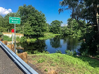
The Palmer River is a river in the U.S. states of Massachusetts and Rhode Island. It flows approximately 17 km (11 mi).
The Branch River, a watercourse of the Mid-Coast Council system, is located in the Mid North Coast and Upper Hunter regions of New South Wales, Australia.
The Campbell Branch Little Black River is a short river in Quebec (Canada) and northern Maine.
The North Branch Meduxnekeag River is a river in Aroostook County, Maine and Carleton County, New Brunswick. From the outlet of a small pond in Maine Township 8, Range 3, WELS, the river runs about 20 miles (30 km) northeast, south, and east to the Canada–United States border, crossing into Canada at 46°16′40″N67°46′56″W. It runs about 4 miles (6 km) southeast to its confluence with the Meduxnekeag River in Wakefield, NB.