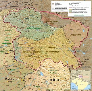
Baltistan also known as Baltiyul or Little Tibet, is a mountainous region in the Pakistani-administered territory of Gilgit–Baltistan. It is located near the Karakoram and borders Gilgit to the west, China's Xinjiang to the north, Indian-administered Ladakh to the southeast, and the Indian-administered Kashmir Valley to the southwest. The average altitude of the region is over 3,350 metres (10,990 ft). Baltistan is largely administered under the Baltistan Division.

Gilgit is the capital city of Gilgit–Baltistan, Pakistan. The city is located in a broad valley near the confluence of the Gilgit River and the Hunza River. It is a major tourist destination in Pakistan, serving as a hub for trekking and mountaineering expeditions in the Karakoram mountain range.

Skardu is a city located in Gilgit−Baltistan, Pakistan. Skardu serves as the capital of Skardu District and the Baltistan Division. It is situated at an elevation of nearly 2,500 metres in the Skardu Valley, at the confluence of the Indus and Shigar Rivers. The city is an important gateway to the eight-thousanders of the nearby Karakoram mountain range. The Indus River running through the region separates the Karakoram from the Ladakh Range.

The Gilgit Agency was an agency of the British Indian Empire consisting of the subsidiary states of the princely state of Jammu and Kashmir at its northern periphery, mainly with the objective of strengthening these territories against Russian encroachment. The subsidiary states included Hunza, Nagar and other states in the present day districts of Gupis-Yasin, Ghizer, Darel, Tangir and Diamer. The agency headquarters was based in the town of Gilgit, which was itself under the direct administration of the Maharaja of Jammu and Kashmir.

Kargil or Kargyil is a city and a joint capital of the union territory of Ladakh, India. It is also the headquarters of the Kargil district. It is the second-largest city in Ladakh after Leh. Kargil is located 204 kilometres (127 mi) east of Srinagar in Jammu and Kashmir, and 234 kilometres (145 mi) to the west of Leh. It is on the bank of the Suru River near its confluence with the Wakha Rong river, the latter providing the most accessible route to Leh.

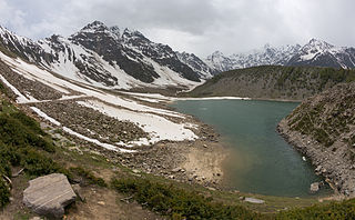
Rama Lake is a lake located near Astore in Gilgit−Baltistan, Pakistan. It is situated within the Astore Valley, which has a light covering of oak trees and other greenery. As of 2013, the region has been greatly affected by the loss of forest cover, low average rainfall and low vegetation, due in part to widespread illegal logging practices in the valley.

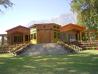
The Ghanche District is the easternmost district of the 14 districts of Pakistan-administered territory of Gilgit-Baltistan. Pakistan Army's brigade headquarters is located at Goma, Ghanche district. Pakistan Army's Gayari Sector Battalion Headquarters is 20 miles (32 km) west of Siachen Glacier. With its administrative headquarters in the historic city of Khaplu, the Ghanche District is famous as a tourist destination for its outstanding scenery and high altitude landscapes.

The Diamer District, also spelled Diamir District,) is a district in Gilgit-Baltistan territory of Pakistan. The headquarters of the district is the town of Chilas. The district is bounded by on the north by the Tangir and the Gilgit districts, on the east by the Astore District, on the south by the Mansehra district of Pakistan's Khyber Pakhtunkhwa Province and the Neelum District of Azad Kashmir, and on the west by the Upper Kohistan District of Khyber Pakhtunkhwa Province. The Karakoram Highway passes through the Diamer District.

Astore District is one of the 14 districts of the Pakistani-administered territory of Gilgit−Baltistan. Its administrative headquarters are located at Eidgah in the Astore Valley. The Astore District is bounded by Gilgit District to the north, Roundu District to the northeast, Skardu District to the east, Kharmang District to the southeast, Diamer District to the west, the Neelum District of Azad Jammu and Kashmir to the southwest, and the Bandipore District of Indian-administered Jammu and Kashmir to the south.

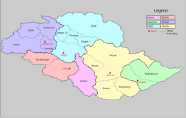
Gilgit-Baltistan is an administrative territory of Pakistan in the northern part of the country. It was given self-governing status on August 29, 2009. Gilgit-Baltistan comprises 14 districts within three divisions. The four districts of Skardu Kharmang Shigar and Ghanche are in the Baltistan Division, four districts of Gilgit Ghizer Hunza and Nagar districts which were carved out of Gilgit District are in the Gilgit Division and the third division is Diamir, comprising Chilas and Astore. The main political centres are the towns of Gilgit and Skardu.

Jammu and Kashmir, officially known as the Princely State of Kashmir and Jammu, was a princely state during the Company rule from 1846 to 1858 as well as the British Raj in India from 1858 to 1947. The princely state was created after the First Anglo-Sikh War, from the territories that had earlier been in the Sikh Empire. After the British Raj ended and the Partition of India happened in 1947, the state was briefly independent, till roughly a third of the state came under Pakistani control after a Pakistani-supported invasion of Pashtun tribesman. The rest remains disputed under Indian and Chinese control. The India–Pakistan dispute regarding the accession remains unresolved.

Gilgit-Baltistan, formerly known as the Northern Areas, is a region administered by Pakistan as an administrative territory and constituting the northern portion of the larger Kashmir region which has been the subject of a dispute between India and Pakistan since 1947, and between India and China from somewhat later. It borders Azad Kashmir to the south, the province of Khyber Pakhtunkhwa to the west, the Wakhan Corridor of Afghanistan to the north, the Xinjiang region of China, to the east and northeast, and the Indian-administered union territories Jammu and Kashmir and Ladakh to the southeast.

Brigadier Sher Jung Thapa MVC was a military officer of the Jammu and Kashmir State Forces and later the Indian Army. Revered as the Hero of Skardu, he was a recipient of the Indian Army's second highest gallantry award, the Maha Vir Chakra (MVC).

The Nagar District is one of the 14 districts of Pakistan-administered territory of Gilgit-Baltistan. The Nagar District was established in 2015 by the division of the Hunza–Nagar District into two districts: the Hunza District and the Nagar District. The Nagar District is bounded on the north and north-east by the Hunza District, on the south-east by the Shigar District, on the south by the Gilgit District, and on the west by the Gupis-Yasin District. The district headquarters in the town of Nagarkhas.

Tourism in Gilgit-Baltistan, an administered territory of Pakistan, focuses on its access to various mountain ranges and alpine terrain.

Shigar District is one of the 14 districts of Pakistani territory of Gilgit-Baltistan. The district is bounded on the north by the Nagar District, the Hunza District, and the Kashgar Prefecture of China's Xinjiang Uyghur Autonomous Region, on the south-east by the Ghanche District, on the south-west by the Rondu District and the Skardu District, and on the west by the Gilgit District. The Shigar District was established in 2015, prior to which time it had been part of the Skardu District.

Karakoram International University or Karakoram University is an international level university in Gilgit-Baltistan, Pakistan. It was established in 2002 with a charter from the Federal Government of Pakistan, with the goal of improving access to higher education for the people of Gilgit-Baltistan. The KIU is one of two public university in the Gilgit–Baltistan region of Pakistan, along with University of Baltistan in Skardu.

Bunji (Urdu:بنجی) is a town in Astore District, Gilgit-Baltistan, Pakistan. it is historically important being in the end of Dogra rule before 1948 and on the edge of ancient Yagistan. It was economically hub for barter trade between Yagistan and Dogras. The distance from Bunji to Gilgit is about 50 kilometres (31 mi) on the Karakoram Highway. Bunji, located at the junction of Three Great Mountain Ranges, has its historical importance. The village has its prominent traces in the socio-political and economical situations of the region in History. Literacy rate of bunji is almost 100 percent except outsider coming from other places for jobs. River Indus covers the village from North to west while from eastern side it is connected with river Astore. Baltistan region joins its territory from the North-East.


