
Sulham is a village and civil parish in West Berkshire, England. The larger village of Tidmarsh is adjacent to Sulham on the west side and of Tilehurst on the east side.
Church Shocklach is a former civil parish, now in the parish of Shocklach Oviatt and District, in the Borough of Cheshire West and Chester and ceremonial county of Cheshire in England. In 2001 it has a population of 113, increasing to 290 at the 2011 Census. The parish included most of the village of Shocklach. The civil parish was abolished in 2015 to form Shocklach Oviatt and District.

Horton by Malpas is a former civil parish, now in the parish of Shocklach Oviatt and District, in the Borough of Cheshire West and Chester and ceremonial county of Cheshire in England. In 2001 it has a population of 62. The parish included the hamlet of Horton Green. The civil parish was abolished in 2015 to form Shocklach Oviatt and District.
Anderton is a civil parish in the Borough of Chorley, Lancashire, England. It contains twelve buildings that are recorded in the National Heritage List for England as designated listed buildings, all of which are listed at Grade II. This grade is the lowest of the three gradings given to listed buildings and is applied to "buildings of national importance and special interest". The parish is mainly rural, with its northern part containing residential areas linking with the town of Adlington. The listed buildings reflect the agricultural history of the parish, with nine of them being farmhouses or farm buildings. The other listed buildings are a portion of a medieval cross, the remains of a set of stocks, and a house from the early 20th century.
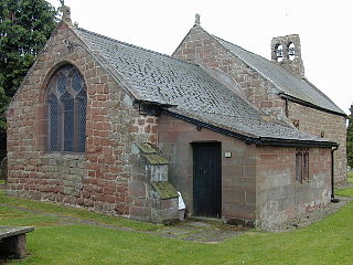
Church Shocklach is a former civil parish, now in the parish of Shocklach Oviatt and District, in Cheshire West and Chester, England. It contains three buildings that are recorded in the National Heritage List for England as designated listed buildings. Of these, one is listed at Grade I, and the other two at Grade II. The parish contains part of the village of Shocklach, and is otherwise rural. The listed buildings consist of a Norman church, a Medieval cross in the churchyard, and a farmhouse that was originally timber-framed.
Huntington is a civil parish in Cheshire West and Chester, England. It contains nine buildings that are recorded in the National Heritage List for England as designated listed buildings, all of which are at Grade II. This grade is the lowest of the three gradings given to listed buildings and is applied to "buildings of national importance and special interest". The parish is entirely rural, and all the listed buildings are domestic or related to farming.
There are over 9,000 Grade I listed buildings in England. This page is a list of these buildings in the unitary authority of Cheshire West and Chester.
Thornton-le-Moors is a civil parish in Cheshire West and Chester, England. It contains nine buildings recorded in the National Heritage List for England as designated listed buildings. Of these, one is listed at Grade I, the highest of the three grades, and the others are at Grade II, the lowest grade. Apart from the village of Thornton-le-Moors, the parish is rural, other than the area north of the A5117 road, which is occupied by an oil refinery. The listed buildings consist of the village church and associated structures, houses, farmhouses, and farm buildings.
Wigland is a civil parish in Cheshire West and Chester, England. It contains three buildings that are recorded in the National Heritage List for England as designated listed buildings, all of which are listed at Grade II. This grade is the lowest of the three gradings given to listed buildings and is applied to "buildings of national importance and special interest". The parish is entirely rural, and the listed buildings consist of farmhouses and farm buildings
Adlington is a civil parish in Lancashire, England. It contains twelve buildings that are recorded in the National Heritage List for England as designated listed buildings, all of which are designated at Grade II. This grade is the lowest of the three gradings given to listed buildings and is applied to "buildings of national importance and special interest". The parish contains the small town of Adlington, which is surrounded by countryside. The listed buildings in the town consist of a row of three cottages, an active church, a redundant church, and a former school and master's house. Outside the town, the listed buildings are mainly houses, farmhouses, and farm buildings. The Leeds and Liverpool Canal runs through the parish, and two bridges crossing it and an aqueduct carrying it over a river are listed.
Pleasington is a civil parish in Blackburn with Darwen, Lancashire, England. The parish contains 12 buildings that are recorded in the National Heritage List for England as designated listed buildings. Of these, one is listed at Grade I, the highest of the three grades, one at Grade II*, the middle grade, and the others are at Grade II, the lowest grade. Apart from the village of Pleasington, the parish is rural, and many of the listed buildings are farmhouses. The other listed buildings are the parish church, an ice house, an entrance to Woodfold Park, and three bridges.
Hapton is a civil parish in the borough of Burnley, Lancashire, England. The parish contains seven buildings that are recorded in the National Heritage List for England as designated listed buildings. Of these, one is listed at Grade I, the highest of the three grades, one at Grade II*, the middle grade, and the others are at Grade II, the lowest grade. Apart from the village of Hapton, and some industrial encroachment from Burnley to the northeast the parish is rural. Three of the listed buildings are or have been farmhouses. The most notable building in the parish is Shuttleworth Hall; this together with associated structures, is listed. The Leeds and Liverpool Canal passes through the parish, and two of the bridges crossing it are listed.
Heskin is a civil parish in the Borough of Chorley, Lancashire, England. It contains 17 buildings that are recorded in the National Heritage List for England as designated listed buildings. Of these, one is listed at Grade I, the highest of the three grades, one is at Grade II*, the middle grade, and the others are at Grade II, the lowest grade. The parish is almost completely rural, and most of the listed buildings are, or originated as, farmhouses and farm buildings. The other listed buildings are large houses and associated structures, and a cottage.
Ulnes Walton is a civil parish in the Borough of Chorley, Lancashire, England. It contains five buildings that are recorded in the National Heritage List for England as designated listed buildings, all of which are listed at Grade II. This grade is the lowest of the three gradings given to listed buildings and is applied to "buildings of national importance and special interest". The parish is almost entirely rural, and the listed buildings consist of farmhouses and farm buildings, and a boundary stone.
Bashall Eaves is a civil parish in Ribble Valley, Lancashire, England. It contains 22 listed buildings that are recorded in the National Heritage List for England. Of these, three are at Grade II*, the middle grade, and the others are at Grade II, the lowest grade. The parish contains the village of Bashall Eaves, and is otherwise rural. The most important building in the parish is Bashall Hall; this and structures are associated with it are listed. Most of the other listed buildings are houses and associated structures, farmhouses and farm buildings. In addition, three bridges and a public house are listed.
Thornley-with-Wheatley is a civil parish in Ribble Valley, Lancashire, England. It contains nine listed buildings that are recorded in the National Heritage List for England. All of the listed buildings are designated at Grade II, the lowest of the three grades, which is applied to "buildings of national importance and special interest". The parish is entirely rural, and most of the listed buildings are farmhouses and farm buildings. The other listed buildings are a house, a church and presbytery, and a mounting block.
West Bradford is a civil parish in Ribble Valley, Lancashire, England. It contains nine listed buildings that are recorded in the National Heritage List for England. All of the listed buildings are designated at Grade II, the lowest of the three grades, which is applied to "buildings of national importance and special interest". The parish contains the village of West Bradford and surrounding countryside. Most of the listed buildings are house, farmhouses and associated structures, the others comprising a public house and a bridge.
Myndtown is a civil parish in Shropshire, England. It contains eight listed buildings that are recorded in the National Heritage List for England. Of these, one is at Grade II*, the middle of the three grades, and the others are at Grade II, the lowest grade. The parish contains the villages of Asterton and Myndtown and the surrounding countryside. Apart from a church that originated in the 12th century, all the listed buildings are houses, cottages, farmhouses, and farm buildings.


