See also
This article includes a geography-related list of lists.
The Lists of rivers of U.S. insular areas include:

This is a list of the lists of islands in the world grouped by country, by continent, by body of water, and by other classifications. For rank-order lists, see the other lists of islands below.

The Ohio River is a 981-mile (1,579 km) long river in the United States. It is located at the boundary of the Midwestern and Southern United States, flowing southwesterly from far-western Pennsylvania south of Lake Erie to its mouth on the Mississippi River at the southern tip of Illinois. It is the third largest river by discharge volume in the United States and the largest tributary by volume of the north-south flowing Mississippi River that divides the eastern from western United States. It is also the 6th oldest river on the North American continent. The river flows through or along the border of six states, and its drainage basin includes parts of 14 states. Through its largest tributary, the Tennessee River, the basin includes several states of the southeastern U.S. It is the source of drinking water for three million people.
This page serves as an index of lists of United States Supreme Court cases. The United States Supreme Court is the highest federal court of the United States.

This is a comprehensive list of lists of rivers, organized primarily by continent and country.
This article contains links to lists of hospitals in the United States, including U.S. States, the District, insular areas, and outlying islands. Links to more detailed state lists are shown. According to a report by the Sheps Center for Health Services Research at the University of North Carolina in 2017, 79 mostly rural hospitals have closed since 2010, mostly across the Southern United States.
The pages below contain lists of television stations in the U.S. by call sign.

The protected areas of the United States are managed by an array of different federal, state, tribal and local level authorities and receive widely varying levels of protection. Some areas are managed as wilderness, while others are operated with acceptable commercial exploitation. As of 2020, the 36,283 protected areas covered 1,118,917 km2 (432,016 sq mi), or 12 percent of the land area of the United States. This is also one-tenth of the protected land area of the world. The U.S. also had a total of 787 National Marine Protected Areas, covering an additional 3,210,908 km2 (1,239,739 sq mi), or 37 percent of the total marine area of the United States.

This is a list of properties and historic districts in Washington that are listed on the National Register of Historic Places. There are at least three listings in each of Washington's 39 counties.
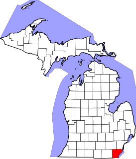
This is a list of the National Register of Historic Places listings in Monroe County, Michigan.

Various lists of the Wonders of the World have been compiled from antiquity to the present day, in order to catalogue the world's most spectacular natural features and human-built structures.

This article is a collection of lists of natural and artificial waterways.

This is a list of the National Register of Historic Places listings in Davenport, Iowa. This is intended to be a complete list of the properties and districts on the National Register of Historic Places in Davenport, Iowa, United States. Latitude and longitude coordinates are provided for many National Register properties and districts; these locations may be seen together in an online map.