
Snowdonia is a mountainous region in northwestern Wales and a national park of 823 square miles (2,130 km2) in area. It was the first to be designated of the three national parks in Wales, in 1951. It contains the highest peaks in the United Kingdom outside Scotland.

Offa's Dyke Path is a long-distance footpath broadly following the Wales–England border. Officially opened on 10 July 1971, by Lord Hunt, it is one of Britain's National Trails and draws walkers from throughout the world. About 60 miles (97 km) of the 177-mile (285 km) route either follows, or keeps close company with, the remnants of Offa's Dyke, an earthwork, most of which was probably constructed in the late 8th century on the orders of King Offa of Mercia.

Powys is a principal area and county, and one of the preserved counties of Wales. It is named after the Kingdom of Powys which was a Welsh successor state, petty kingdom and principality that emerged during the Middle Ages following the end of Roman rule in Britain.
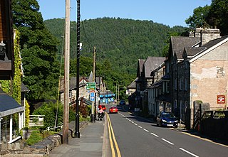
Betws-y-coed ; English: prayer house in the wood) is a village and community in the Conwy valley in Conwy County Borough, Wales, located in the historic county of Caernarfonshire, right on the boundary with Denbighshire, in the Gwydir Forest. It is now a very popular visitor destination in the Snowdonia National Park.

Llanishen is a district and community in the north of Cardiff, the capital city of Wales. The Cardiff community population taken at the 2011 census was 17,417. Llanishen is the former home of the 'Tax Offices', the tallest buildings in north Cardiff and a landmark for miles around. The office complex overlooks the 'Crystal and Fishguard estates', the Parc Tŷ Glas industrial estate, Llanishen village, leafy suburban roads and parks that constitute the district. Llanishen is also home to a Leisure Centre and the former 60-acre (24 ha) Llanishen Reservoir – a local beauty spot that is connected to a green corridor which bisects the city from the rising hills in the north to Cardiff Bay in the south.

The Taff Trail is a popular walking and cycle path that runs for 55 miles (89 km) between Cardiff Bay and Brecon in Wales. It is so named because it follows the course of the River Taff. Along much of its length, it follows the National Cycle Network Route 8 that continues to Holyhead, and is substantially off-road.

The River Taff is a river in Wales. It rises as two rivers in the Brecon Beacons; the Taf Fechan and the Taf Fawr before becoming one just north of Merthyr Tydfil. Its confluence with the River Severn estuary is in Cardiff.

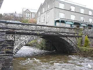
The River Conwy is a river in north Wales. From its source to its discharge in Conwy Bay it is 55 kilometres (34 mi) long and drains an area of 678 square km. "Conwy" was formerly Anglicised as "Conway."

The Clwydian Range is a series of hills in north east Wales that runs from Llandegla in the south to Prestatyn in the north, with the highest point being the popular Moel Famau. The range forms part of the Clwydian Range and Dee Valley Area of Outstanding Natural Beauty.
Gwydir Forest, also spelled Gwydyr, is located in Conwy county borough and the Snowdonia National Park in Wales. It takes its name from the ancient Gwydir Estate, established by the John Wynn family of Gwydir Castle, which owned this area.

Ruabon Moors are an area of upland moorland in Wales to the west of Ruabon and Wrexham. They lie partly within Wrexham county borough and partly within Denbighshire.

The Horseshoe Pass is a mountain pass in Denbighshire, north-east Wales. It separates Llantysilio Mountain to the west from the 565 metre mountain and Marilyn Cyrn-y-Brain to the east. The A542 road from Llandegla to Llangollen runs through the pass, reaching a maximum height of 417 metres (1,368 ft). The road travels in a horseshoe shape around the sides of a valley, giving the pass its English name.
The Afon Crafnant is a tributary of the River Conwy, which is the main river of the Conwy valley in north-west Wales.

Llandegla or Llandegla-yn-Iâl is a village and community in the county of Denbighshire in Wales. In the 2011 census, the community had a population of 567.
The Clwydian Way is a waymarked long-distance footpath in the United Kingdom, running through Denbighshire in north-east Wales.
Macclesfield Forest is an area of woodland, predominantly conifer plantation, located around 3 mi (5 km) south east of Macclesfield in the civil parish of Macclesfield Forest and Wildboarclough, in Cheshire, England. The existing woodland is the last substantial remnant of the Royal Forest of Macclesfield, a once-extensive ancient hunting reserve. The area also includes two reservoirs, Trentabank and Ridgegate. Macclesfield Forest lies on the western edge of the Peak District, within the South West Peak, and is partly inside the boundary of the National Park. The hills of Tegg's Nose and Shutlingsloe stand to the north west and south east, respectively; the moorland of High Moor lies to the south and the Goyt Valley lies to the west. Nearby villages include Langley and Wildboarclough.

The Afon Clun is a 14-mile (23 km) long tributary of the River Ely, in the counties of Cardiff and Rhondda Cynon Taf, Wales. Its bedrock is predominantly of sandstone. Beginning on the western slope of The Garth the river is fast-flowing, in clear shallow water with a hard substrate, flowing to the south of Llantrisant and generally west to its confluence with the River Ely at Pontyclun, falling 715 feet (218 m) over its course.

Hafod Elwy Moor National Nature Reserve, located in the moorland above the town of Denbigh in Denbighshire, North Wales, is part of the Mynydd Hiraethog Site of Special Scientific Interest, formerly managed by the Countryside Council for Wales and now under the jurisdiction of Natural Resources Wales. Established in 1999, it comprises an 82-hectare (200-acre) patch of upland moor lying between the lakes of Llyn Brenig and Llyn Alwen. A conifer forest planted by the Forestry Commission borders the moor to the south and east.

Bro Machno is a community in Conwy County Borough, in Wales, formed from the former civil parish of Penmachno. It covers the Penmachno Valley, through which runs the Afon Machno, and includes the villages of Penmachno and Cwm Penmachno. To the south west borders Gwynedd, and is located 4.8 miles (7.7 km) south of Betws-y-Coed, 21.8 miles (35.1 km) north west of Corwen, and 19.4 miles (31.2 km) south of Conwy. The whole of the community is within the Snowdonia national park, while much of it forms part of Gwydir Forest. According to the 2011 census, the population of the Bro Machno Parish was 617, of whom 342 (55%) were able to speak Welsh and 214 (34%) had no skills in Welsh.

Nant-y-Ffrith refers to a stream and the wooded valley through which it flows on the border between Flintshire and Wrexham County Borough in Wales. The stream begins in moorland to the east of Llandegla. It passes Bwlchgwyn village before entering a rather steep-sided, rocky valley. It passes under the viaduct of a disused railway line before joining the River Cegidog at Ffrith.
