
Crickhowell is a town and community in southeastern Powys, Wales, near Abergavenny, and is in the historic county of Brecknockshire.

The Taff Trail is a walking and cycle path that runs for 55 miles (89 km) between Cardiff Bay and Brecon in Wales. It is so named because it follows the course of the River Taff. Along much of its length, it follows the National Cycle Network Route 8 that continues to Holyhead, and is substantially off-road.

The Sugar Loaf is a hill situated two miles (3.2 km) north-west of Abergavenny in Monmouthshire, Wales, within the Brecon Beacons National Park. It is the southernmost of the summit peaks of the Black Mountains, and rises to 1,955 feet (596 metres). The Sugar Loaf was gifted to the National Trust by suffragette Lady Rhondda.

Rhiwderin is a small village in the west of the city of Newport, South Wales.
Mamhilad is a village in the community of Goetre Fawr in Monmouthshire, south east Wales.

Partrishow, also known as Patricio, Patrishow, or by its Welsh names Merthyr Isw and Llanisw, is a small village and historic parish in the county of Powys, close to its border with Monmouthshire. It is in the valley of the Grwyne Fawr, in the Black Mountains of South Wales, within the Brecon Beacons National Park.

The Beacons Way is a waymarked long distance footpath in the Brecon Beacons National Park, Wales. It is a linear route which runs for 99 miles (159 km) east to west through the National Park, and passes many of the most important landmarks and mountain peaks in the mountain range. It also includes a few of the towns in the park as well as popular attractions such as Carreg Cennen Castle near Llandeilo at the western end of the path.

Llywel is a small village located on the A40, about 4 miles (6.4 km) west of Sennybridge in Powys, Wales. The Afon Gwydderig runs through the village, not far from its source. Llywel also gives its name to a community. The main settlement in the community is Trecastle. According to the 2001 Census the population of the Llywel community is 524, falling to 497 in the 2011 Census. The village was historically in Brecknockshire.

Coelbren is a small rural village within the community of Tawe Uchaf in southernmost Powys, Wales. It lies on the very northern edge of the South Wales Coalfield some six miles north-east of Ystradgynlais and just outside the southern boundary of the Brecon Beacons National Park. It is known for Henrhyd Falls, a 27m high waterfall which serves as a National Trust-managed visitor attraction on the Nant Llech. To the east of the village flows the Afon Pyrddin which plunges over two more spectacular falls.
Heol Senni is a hamlet in the valley of the Afon Senni just north of the Fforest Fawr section of the Brecon Beacons National Park. It lies within the community of Maescar in the county of Powys, Wales. The Welsh name means the 'road by Senni' and reflects its position near the crossing of the river by the minor road running from the A4067 to the A4215 road. This route was, and to some extent still is, an important link between Brecon and the upper Swansea Valley.

The Grwyne Fawr is a river in the Brecon Beacons National Park in south Wales. A section of it forms the administrative border between Powys and Monmouthshire and also of the historic counties of Brecon and Monmouth. The river and its major tributary the Grwyne Fechan flow into the River Usk at Glangrwyney.

Llangattock is a village, community and electoral ward in the Brecon Beacons National Park in Powys, Wales. It lies in the Usk Valley just across the river from the town of Crickhowell. The Monmouthshire and Brecon Canal passes through the village en route between Brecon and Pontypool. It is in the historic county of Breconshire.

Libanus is a village in the Brecon Beacons National Park, Powys, Wales, United Kingdom, and in the community of Glyn Tarell. Presumably, the name of the village derives from Mount Lebanon, also known as the Lebanon Mountains, the ancient name for which was Libanus, a common name for chapels in Wales.

Penderyn is a Welsh whisky distillery and brand, producing the first commercially available whisky made in Wales since the 19th century. Produced at the Penderyn Distillery, Penderyn is a single malt whisky produced in several expressions, e.g. Madeira Finish, Peated, Sherrywood and Portwood.

Llanspyddid is a small village just west of Brecon within the Brecon Beacons National Park. It lies within the valley of the River Usk in the community of Glyn Tarell in the county of Powys, Wales. Llanspyddid sits on the A40 trunk road between Brecon and Llandovery. The Welsh name signifies the 'church of Saint Ysbyddyd', though the village church is in fact dedicated to Saint Cadog.

Llanfrynach is a village and community in the county of Powys, Wales, and the historic county of Brecknockshire. The population of the community as taken at the 2011 census was 571. It lies just to the southeast of Brecon in the Brecon Beacons National Park. The village sits astride the Nant Menasgin, a right bank tributary of the River Usk. The B4558 passes just to its north and the Monmouthshire and Brecon Canal also passes around the village. The Welsh name signifies the 'church of Brynach'. The community includes the hamlets of Llanhamlach and Groesffordd.

Defynnog,, is a small village in the community of Maescar in the historic county of Brecknockshire, Wales, now lying within the unitary authority area of Powys. It lies immediately south of Sennybridge and about ten miles west of Brecon within the Brecon Beacons National Park.
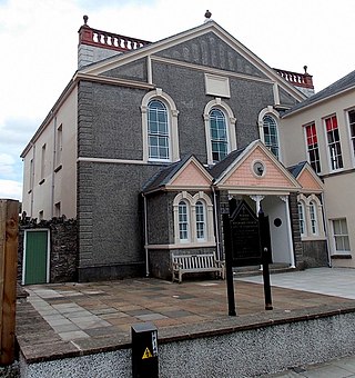
Plough Lane Chapel or Plough United Reformed Church is a historic building in Brecon, Wales. The chapel's foundation dates to the 17th century and the structure was rebuilt in 1841, then again in 1892. Cadw, the historic environment service of the Welsh Government, listed the chapel as a Grade II* historic building in 1976 for its "unusual porch" and "elaborate and fine interior".

Brecon Corinthians A.F.C. are a Welsh football club from the town of Brecon in Powys. The club played for much of its history in the Welsh Football League, as well as spells in league in South and Mid Wales. They currently play in the Ardal SE League.
Richard William Payne Davies was a Welsh Anglican priest in the 19th century, the archdeacon of Brecon from 1859 to 1875..
