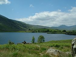
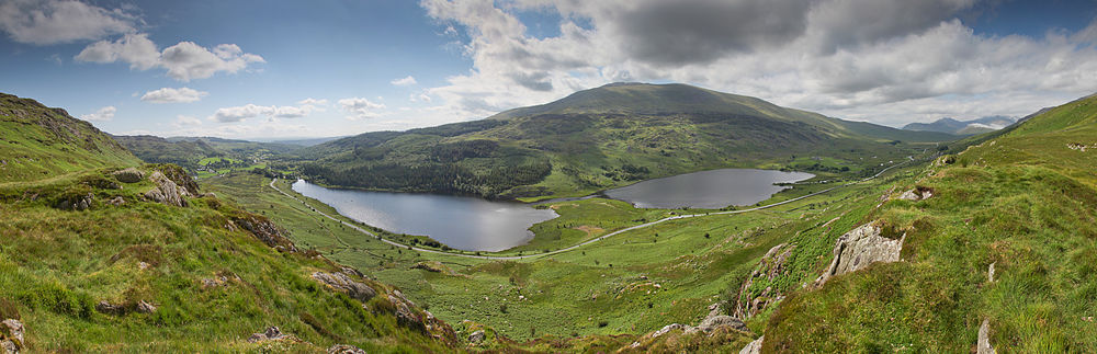
Llynnau Mymbyr are two lakes located in Dyffryn Mymbyr, a valley running from the village of Capel Curig to the Pen-y-Gwryd hotel in Snowdonia, north-west Wales. The A4086 runs along their northern banks.
Strictly speaking this is one lake, originally called Llyn Mymbyr, with a maximum depth of 30 feet. About 3/4 mile long in total, a delta has built up midway along the north shore, and this has to all purposes cut the lake in two - hence the plural name.
The river feeding the lakes is the Nantygwryd (or Nant-y-gwryd), which has its source at Llyn Cwm-y-ffynnon, also marked on maps as the Nant Gwryd, which is a tributary of the Afon Llugwy. The two rivers join at Capel Curig.
The lake was used for fly-fishing and sub-aqua courses in the 1960s and is still used today as a canoe training resource by Plas y Brenin and other local education authorities.
Geographical and Geological Context
The lakes lie in a depression formed by a ring of sandstone called the Capel Curig Volcanic Formation which can be vaguely seen in the panorama below which was taken from the north side. The igneous rocks of Moel Siabod can be seen behind the lakes which are linear but in the panorama appear to bend at the delta between the two.
Snowdonia is a mountainous region in northwestern Wales and a national park of 823 square miles (2,130 km2) in area. It was the first to be designated of the three national parks in Wales, in 1951. It contains the highest peaks in the United Kingdom outside Scotland.
Capel Curig is a village and community in the historic county of Caernarfonshire, currently administered as part of the unitary authority of Conwy County Borough, in Wales. It lies in the heart of Snowdonia, on the River Llugwy, and has a population of 226, reducing slightly to 206 at the 2011 census. It lies at the junction of the A5 road from Bangor and Bethesda to Betws-y-Coed with the A4086 road from Caernarfon, Llanberis, Pen-y-Pass and Pen-y-Gwryd. It is surrounded by hills and mountains, including Moel Siabod and Pen Llithrig y Wrach.
Plas y Brenin, located in Conwy County Borough, Wales, is a National Outdoor Centre owned by Sport England. The centre is situated in Dyffryn Mymbyr, the Mymbyr Valley, in Snowdonia and is less than a quarter of a mile south-west of the centre of Capel Curig on the A4086 road.
Pen-y-Pass is a mountain pass in Snowdonia, Gwynedd, north-west Wales. It is a popular location from which to walk up Snowdon, as three of the popular routes can be started here. Glyder Fawr, to the north, is also accessible from here.
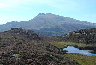
Moel Siabod, is a mountain in Snowdonia, North Wales, which sits isolated above the villages of Betws-y-Coed and Capel Curig. At 872 metres (2,861 ft), it is the highest peak in the Moelwynion mountain range. The UK National Mountain Centre, Plas-y-Brenin, is located at the foot of Moel Siabod. From the top of the mountain, it is reputedly possible to see 13 of the 14 highest peaks in Wales on a clear day without turning one's head.
Pen-y-Gwryd is a pass at the head of Nantygwryd and Nant Cynnyd rivers close to the foot of Snowdon in Gwynedd, Wales. The area is located at the junction of the A4086 from Capel Curig to Llanberis and Caernarfon and the A498 from Beddgelert and Nant Gwynant about a mile from the head of the Llanberis Pass. It is close to the boundary with Conwy county borough in northern Snowdonia. The famous mountaineering hostelry, Pen-y-Gwryd Hotel, is located in the pass. It is also a mountain rescue post with links to the other rescue posts at Ogwen Cottage and Plas y Brenin.
The Llanberis Pass in Snowdonia carries the main road (A4086) from the south-east to Llanberis, over Pen-y-Pass, between the mountain ranges of the Glyderau and the Snowdon massif. At the bottom of the pass is the small village of Nant Peris.
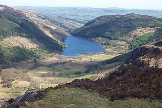
Llyn Crafnant is a lake that lies in a valley in Wales where the northern edge of the Gwydir Forest meets the lower slopes of the Carneddau mountains and, more specifically, the ridge of Cefn Cyfarwydd. The head of the valley offers a profile of crags which are silhouetted at sunset. The Forest Park guide (2002) states that "the is one of the most breathtaking views in all Snowdonia". The summits include Crimpiau 475 metres, and Craig Wen 548 metres which provide views to Moel Siabod and the Ogwen Valley, and Snowdon. Further up is Creigiau Gleision. At 63 acres (250,000 m2) it is the best part of a mile long, although it was clearly once much longer - its southern end shows the evidence of centuries of silting. Jehu’s survey (see references) recorded a maximum depth of 71 ft (22 m).
Nant Gwynant is a valley in north Wales. The A498 road descends 600 feet (180 m) into the valley in about two miles from Pen-y-Gwryd; it follows the Nant Cynnyd, the Afon Glaslyn and alongside Llyn Gwynant, then beside the Nant Gwynant river to Llyn Dinas and passing below Dinas Emrys to Beddgelert. The road continues through the Aberglaslyn Pass to Porthmadog.
The Nant Ffrancon Pass in Snowdonia, North Wales, is the long steady climb of the A5 road between Bethesda, Gwynedd, and Llyn Ogwen in Conwy. The summit at 312 metres (1,024 ft) is at Pont Wern-gof, about one-third of a mile beyond the eastern end of Llyn Ogwen. From here the road descends through Nant y Benglog to Capel Curig and through to Betws-y-Coed. The A5 is the Holyhead to London trunk road, which was re-engineered by Thomas Telford between 1810 and 1826. The original road through the Nant Ffrancon was constructed by Lord Penrhyn in the late 18th century, and at Capel Curig in 1801 he built a coaching inn, which is now Plas y Brenin, the UK National Mountaineering Centre.
Geirionydd was a rural district in the administrative county of Caernarvonshire, North Wales from 1894 to 1934.
Cwm Idwal is a cirque in the Glyderau range of mountains in northern Snowdonia, the national park in the mountainous region of North Wales. Its main interest is to hill walkers and rock climbers, but it is also of interest to geologists and naturalists, given its combination of altitude, aspect (north-facing) and terrain. In a 2005 poll conducted by Radio Times, Cwm Idwal was ranked the 7th greatest natural wonder in Britain.
Dyffryn Mymbyr is a valley in Snowdonia, in north-west Wales, approximately 5 miles (8.0 km) in length, and leading up from Capel Curig to the Pen-y-Gwryd hotel.
The Nant y Cynnyd is a small river in Gwynedd, north Wales, starting near the Pen-y-Gwryd hotel near Capel Curig. The Ordnance Survey map is not completely specific, but the river grows into Afon Glaslyn and into Llyn Gwynant.
The A4086 is an A road in Gwynedd. The road goes between Caernarfon and the A5 near Capel Curig.
Llyn Cwm-y-ffynnon is a lake in Snowdonia, below the summit of Moel Berfedd in Cwmffynnon. The lake's original name was Fynnon Mymbyr as outlined in Llywelyn ap Iorwerth's charter of 1198. As the name suggests, the lake nestles in a short valley, a cwm, high above the Pen-y-Gwryd hotel. The lake is the source of the Nantygwryd, river which in Welsh translates to Pen-y-Gwryd.
Buan is a community in the Welsh county of Gwynedd, located on the Llŷn Peninsula. It includes the villages of Boduan and Rhydyclafdy, and has a population of 469, increasing to 484 at the 2011 Census.
Trefeurig is a community in Mid and West Wales, situated around 4 miles (6.4 km) north-east of Aberystwyth. It is a site of particular prehistoric, Roman, and Iron Age interest, and has a long history as a mining area. In 2011 the local population was estimated at around 1,771 people.
Bragdy Nantpronunciation (help·info) is an ale brewery near the town of Llanrwst, North Wales. The brewery produces cask and bottle-conditioned ales, and is one of four North Wales breweries jointly operating the Albion Ale House in the town of Conwy. The name Bragdy Nant is Welsh for River or Stream Brewery.
The geology of Snowdonia National Park is dominated by sedimentary and volcanic rocks from the Cambrian and Ordovician periods with intrusions of Ordovician and Silurian age. There are Silurian and Cenozoic sedimentary rocks on the park's margins. The succession was intensely faulted and folded during the Caledonian Orogeny. The region was uplifted as the North Atlantic Ocean opened during the Cenozoic. The current mountainous landscape arises from repeated glaciations during the Quaternary period.
This page is based on this Wikipedia article Text is available under the CC BY-SA 4.0 license; additional terms may apply. Images, videos and audio are available under their respective licenses.