Related Research Articles

The Allegheny River is a 325-mile (523 km) long headwater stream of the Ohio River in western Pennsylvania and New York. The Allegheny River runs from its headwaters just below the middle of Pennsylvania's northern border northwesterly into New York then in a zigzag southwesterly across the border and through Western Pennsylvania to join the Monongahela River at the Forks of the Ohio on the "Point" of Point State Park in Downtown Pittsburgh, Pennsylvania. The Allegheny River is, by volume, the main headstream of both the Ohio and Mississippi Rivers. Historically, the Allegheny was considered to be the upper Ohio River by both Native Americans and European settlers.

Schuylkill County is a county in the U.S. state of Pennsylvania. As of the 2020 census, the population was 143,049. The county seat is Pottsville. The county was created on March 1, 1811, from parts of Berks and Northampton counties and named for the Schuylkill River, which originates in the county. On March 3, 1818, additional territory in its northeast was added from Columbia and Luzerne counties.

Penn Hills is a township with home rule status in Allegheny County, Pennsylvania, United States. The population as of the 2010 census was 42,329. Penn Hills is the second-largest municipality in Allegheny County, after the city of Pittsburgh.

Plum is a borough in Allegheny County in the U.S. state of Pennsylvania. A suburb of Pittsburgh, Pennsylvania, it is located northeast of the city of Pittsburgh, in what is commonly referred to as the East Hills suburbs. In 2018, Plum's population was 27,135.

Springdale is a borough in Allegheny County, Pennsylvania, 18 miles (29 km) northeast of Pittsburgh along the Allegheny River. The population was 3,405 at the 2010 census.

The Herefordshire and Gloucestershire Canal is a canal in the west of England, which ran from Hereford to Gloucester, where it linked to the River Severn. It was opened in two phases in 1798 and 1845, and closed in 1881, when the southern section was used for the course of the Ledbury and Gloucester Railway. It is the subject of an active restoration scheme.
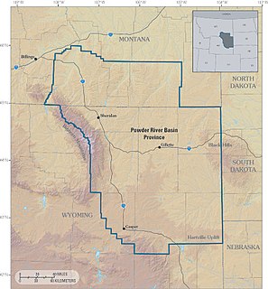
The Powder River Basin is a geologic structural basin in southeast Montana and northeast Wyoming, about 120 miles (190 km) east to west and 200 miles (320 km) north to south, known for its extensive coal reserves. The former hunting grounds of the Oglala Lakota, the area is very sparsely populated and is known for its rolling grasslands and semiarid climate.

This is a list of the earliest railroads in North America, including various railroad-like precursors to the general modern form of a company or government agency operating locomotive-drawn trains on metal tracks.

The Main Line of Public Works was a package of legislation passed by the Commonwealth of Pennsylvania in 1826 to establish a means of transporting freight between Philadelphia and Pittsburgh. It funded the construction of various long-proposed canal and road projects, mostly in southern Pennsylvania, that became a canal system and later added railroads. Built between 1826 and 1834, it established the Pennsylvania Canal System and the Allegheny Portage Railroad.
Railroad electrification in the United States began at the turn of the 20th century and comprised many different systems in many different geographical areas, few of which were connected. Despite this situation, these systems shared a small number of common reasons for electrification.

Catawissa Creek is a 41.8-mile-long (67.3 km) tributary of the Susquehanna River in east-central Pennsylvania in the United States. Its watershed has an area of 153 square miles (400 km2).

Thomas Penn was a hereditary proprietor of the Province of Pennsylvania, the English North American colony that became the U.S. state of Pennsylvania. He was a son of William Penn, the colony's founder and original proprietor.
The Seddonville Branch, later truncated as the Ngākawau Branch, is a branch line railway in the West Coast region of New Zealand's South Island. Construction began in 1874 and it reached its terminus at the Mokihinui Mine just beyond Seddonville in 1895. In 1981 it was closed past Ngākawau and effectively became an extension of the Stillwater–Westport Line, since formalised as the Stillwater–Ngākawau Line.

Mahanoy Creek is a 51.6-mile-long (83.0 km) tributary of the Susquehanna River in Northumberland and Schuylkill counties, Pennsylvania. There are at least 35 sources of acid mine drainage in the creek's watershed. Anthracite was mined in the upper part of the Mahanoy Creek watershed in the 19th and 20th centuries. Mahanoy Creek's tributaries include Schwaben Creek, Zerbe Run, Little Mahanoy Creek, Shenandoah Creek, and North Mahanoy Creek. Little Mahanoy Creek and Schwaben Creek are two streams in the watershed that are unaffected by acid mine drainage. Schwaben Creek has a higher number and diversity of fish species than the main stem.
Monaville is an unincorporated community and census-designated place (CDP) in Logan County, West Virginia, United States. As of the 2010 census, its population was 309.
The South Waratah Colliery was a coal mine located at Charlestown, in New South Wales Australia.

Ethel is an unincorporated community in Logan County, West Virginia, United States. Ethel is located on West Virginia Route 17, 4.5 miles (7.2 km) east-northeast of Logan. Ethel has a post office with ZIP code 25076.
Henlawson is a census-designated place (CDP) in Logan County, West Virginia, United States. Henlawson has a post office with ZIP code 25624. As of the 2010 census, its population was 442. Henlawson is believed to have been named after a resident, Henry Lawson. Merrill Coal Mines opened Merrill Mines here in 1921 and built homes to house the miners.
The Beaver Meadow Railroad & Coal Company (BMRC) was chartered April 7, 1830, to build a railroad from the mines near Beaver Meadows, Pennsylvania, beyond Broad Mountain along Beaver Creek to Penn Haven and along the Lehigh River through Mauch Chunk to the Lehigh Canal at Parryville, Pennsylvania. The settlement of Beaver Meadows dated to a 1787 land sale to Patrick and Mary Keene, thence to Nathan Beach.
Plymouth, Pennsylvania sits on the west side of Pennsylvania's Wyoming Valley, wedged between the Susquehanna River and the Shawnee Mountain range. Just below the mountain are hills that surround the town and form a natural amphitheater that separates the town from the rest of the valley. Below the hills, the flat lands are formed in the shape of a frying pan, the pan being the Shawnee flats, once the center of the town's agricultural activities, and the handle being a spit of narrow land extending east from the flats, where the center of town is located. At the beginning of the 19th century, Plymouth's primary industry was agriculture. However, vast anthracite coal beds lay below the surface at various depths, and by the 1850s, coal mining became the town's primary occupation.
References
| Counties |  | |
|---|---|---|
| Major cities | ||
| Cities and towns 15k–50k (in 2010) | ||
| Airports | ||
| Topics | ||
| | This article about a building or structure in Pennsylvania is a stub. You can help Wikipedia by expanding it. |
This United States tunnel–related article is a stub. You can help Wikipedia by expanding it. |