See also
| This disambiguation page lists articles associated with the title Lookouts. If an internal link led you here, you may wish to change the link to point directly to the intended article. |
Lookouts is the plural of lookout, and may also refer to:
| This disambiguation page lists articles associated with the title Lookouts. If an internal link led you here, you may wish to change the link to point directly to the intended article. |
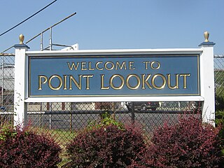
Point Lookout is a hamlet and census-designated place (CDP) located in the town of Hempstead in Nassau County, New York. The population was 1,219 at the time of the 2010 census. The town is mostly made up of residential homes, with several small businesses on Lido Boulevard. The town is surrounded on three sides by water. Today, Point Lookout has become a popular location for summer residences. Among its inhabitants, it is commonly referred to as "PLO".
Lookout Records was an independent record label, initially based in Laytonville, California and later in Berkeley, focusing on punk rock. Established in 1987, the label is best known for having released Operation Ivy’s only album, Energy, and Green Day's first two albums, Kerplunk and 39/Smooth.
The Chattanooga Lookouts are a Minor League Baseball team of the Southern League and the Double-A affiliate of the Cincinnati Reds. They are located in Chattanooga, Tennessee, and are named for nearby Lookout Mountain. The team plays its home games at AT&T Field which opened in 2000 and seats 6,340 fans. They previously played at Engel Stadium from 1930 through 1999, with a one-year break in Montgomery, Alabama's Cramton Bowl in 1943.

The Jamison Valley forms part of the Coxs River canyon system in the Blue Mountains of New South Wales, Australia. It is situated approximately 100 kilometres west of Sydney, capital of New South Wales, and a few kilometres south of Katoomba, the main town in the Blue Mountains.

A fire lookout is a person assigned the duty to look for fire from atop a building known as a fire lookout tower. These towers are used in remote areas, normally on mountain tops with high elevation and a good view of the surrounding terrain, to spot smoke caused by a wildfire.

Lookout Mountain is a mountain ridge located at the northwest corner of the U.S. state of Georgia, the northeast corner of Alabama, and along the Tennessee state line in Chattanooga. Lookout Mountain was the scene of the "Last Battle of the Cherokees" during the Nickajack Expedition, which took place in the 18th century, as well as the November 24, 1863 Battle of Lookout Mountain during the American Civil War.

Sioux Lookout is a town in Northwestern Ontario, Canada. Located approximately 350 km (220 mi) northwest of Thunder Bay, it has a population of 5,272 people and an elevation of 390 m (1,280 ft). Known locally as the "Hub of the North", it is serviced by the Sioux Lookout Airport, Highway 72, and the Sioux Lookout railway station. According to a 2011 study commissioned by the municipality, health care and social services ranked as the largest sources of employment, followed by the retail trade, public administration, transportation and warehousing, manufacturing, accommodation and food services, and education.
The Lookouts were an American punk rock band that existed from 1985 to 1990 on Iron Peak, a remote rural mountain community outside Laytonville, California, United States. The members were Larry Livermore on guitar and vocals, Kain Kong on bass and vocals, and Tré Cool on drums and vocals. All three contributed on songwriting.

Cleveland National Forest encompasses 460,000 acres, mostly of chaparral, with a few riparian areas. A warm dry mediterranean climate prevails over the Forest. It is the southernmost National forest of California. It is administered by the United States Forest Service, a government agency within the United States Department of Agriculture. It is divided into the Descanso, Palomar and Trabuco Ranger Districts and is located in the counties of San Diego, Riverside, and Orange.
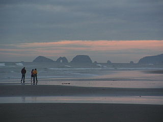
Cape Lookout State Park is a state park on Cape Lookout in the U.S. state of Oregon. It is located in Tillamook County, south of the city of Tillamook, on a sand spit between Netarts Bay and the Pacific Ocean.
Point Lookout State Park is a Maryland state park occupying Point Lookout, the southernmost tip of a peninsula formed by the confluence of Chesapeake Bay and the Potomac River in St. Mary's County, Maryland. The state park preserves the site of an American Civil War prisoner of war camp and the Point Lookout Light, which was built in 1830. It is the southernmost spot on Maryland's western shore, the coastal region on the western side of the Chesapeake Bay.
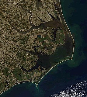
Cape Lookout is the southern point of the Core Banks, one of the natural barrier islands on the Atlantic coast of North Carolina, USA. It delimits Onslow Bay to the west from Raleigh Bay to the east. Core Banks and Shackleford Banks have been designated as parts of the Cape Lookout National Seashore.

The Cape Lookout Lighthouse is a 163-foot high lighthouse located on the Southern Outer Banks of North Carolina. It flashes every 15 seconds and is visible at least 12 miles out to sea and up to 19 miles. The Cape Lookout Light is one of the very few lighthouses that operate during the day. It became fully automated in 1950. The Cape Lookout Lighthouse is the only such structure in the United States to bear the checkered daymark, intended not only for differentiation between similar light towers, but also to show direction. The center of the black diamonds points in a north-south direction, while the center of the white diamonds points east-west.

A fire lookout tower, fire tower or lookout tower, provides housing and protection for a person known as a "fire lookout" whose duty it is to search for wildfires in the wilderness. The fire lookout tower is a small building, usually located on the summit of a mountain or other high vantage point, in order to maximize the viewing distance and range, known as view shed. From this vantage point the fire lookout can see smoke that may develop, determine the location by using a device known as an Osborne Fire Finder, and call fire suppression personnel to the fire. Lookouts also report weather changes and plot the location of lightning strikes during storms. The location of the strike is monitored for a period of days after in case of ignition.

Point Lookout, a mountain on the Snowy Range, a spur of the Great Dividing Range, is located in the New England National Park on the eastern edge of the Northern Tablelands in the New England region of New South Wales, Australia.

Lookout Mountain is a foothill on the eastern flank of the Front Range of the Rocky Mountains of North America. The 7,377-foot (2,249 m) peak is located in Lookout Mountain Park, 1.7 miles (2.7 km) west-southwest of downtown Golden in Jefferson County, Colorado, United States.

USS Lookout (YAGR/AGR-2) was a Guardian-class radar picket ship, converted from a Liberty Ship, acquired by the US Navy in 1954. She was reconfigured as a radar picket ship and assigned to radar picket duty in the North Atlantic Ocean as part of the Distant Early Warning Line.
Mount Zion Demonstration State Forest is located in the town of Pine Grove, Amador County, California, United States. It features a ranger lookout station and microwave tower atop Mount Zion, which is accessed via Mount Zion Road from California State Route 88.

Canadian Forces Station Sioux Lookout is a closed General Surveillance Radar station. It is located 3.7 miles (6.0 km) west of Sioux Lookout, Ontario. It was closed in 1987.

Lookout Mountain at 9,954 feet (3,034 m) above sea level is a peak in the White Cloud Mountains of Idaho. The peak is located in Sawtooth National Recreation Area in Custer County 4.72 mi (7.60 km) from Blackmon Peak, its line parent. A maintained trail goes to the summit where an old U.S. Forest Service fire lookout is located. The lookout was built by the Civilian Conservation Corps and was recently refurbished.