Altadena is an unincorporated area and census-designated place in the Verdugo Mountains region of Los Angeles County, California, approximately 14 miles (23 km) from downtown Los Angeles, and directly north of the city of Pasadena, California. The population was 42,777 at the 2010 census, up from 42,610 at the 2000 census.

The Pacific Electric Railway Company, nicknamed the Red Cars, was a privately owned mass transit system in Southern California consisting of electrically powered streetcars, interurban cars, and buses and was the largest electric railway system in the world in the 1920s. Organized around the city centers of Los Angeles and San Bernardino, it connected cities in Los Angeles County, Orange County, San Bernardino County and Riverside County.

The Arroyo Seco Parkway, also known as the Pasadena Freeway, is one of the oldest freeways built in the United States. The parkway connects Los Angeles with Pasadena alongside the Arroyo Seco seasonal river. It is notable not only for being an early freeway, mostly opened in 1940, but for representing the transitional phase between early parkways and later freeways. It conformed to modern standards when it was built, but is now regarded as a narrow, outdated roadway. A 1953 extension brought the south end to the Four Level Interchange in downtown Los Angeles and a connection with the rest of the freeway system.

Old Pasadena, often referred to as Old Town Pasadena or simply Old Town, is the original commercial center of Pasadena, a city in California, United States, and had a latter-day revitalization after a period of decay.

The Southern California freeways are a vast network of interconnected freeways in the megaregion of Southern California, serving a population of 23 million people. The Master Plan of Metropolitan Los Angeles Freeways was adopted by the Regional Planning Commission in 1947 and construction began in the early 1950s. The plan hit opposition and funding limitations in the 1970s, and by 2004, only some 61% of the original planned network had been completed.

The Arroyo Seco, meaning "dry stream" in Spanish, is a 24.9-mile-long (40.1 km) seasonal river, canyon, watershed, and cultural area in Los Angeles County, California. The area was explored by Gaspar de Portolà who named the stream Arroyo Seco as this canyon had the least water of any he had seen. During this exploration he met the Chief Hahamog-na (Hahamonga) of the Tongva Indians.

Lake Avenue is a major north–south feeder road for the Pasadena and Altadena communities in Los Angeles County, California. The road was developed in the mid 19th century and takes its name from a lake which was located at its southernmost end known variously as Mission Lake, Kewen Lake, and Wilson Lake reflecting different owners of the land. The lake bed still exists as a municipal park in the City of San Marino just south of the Raymond Dike, but it holds no water. It has been surrounded by residences who are served by a crisscross set of roads that dip into the edges of impression and back out the other side. Lake Avenue is approximately 5.06 miles (8.14 km) in length.
Foothill Boulevard is a major road in the city and county of Los Angeles, as well as an arterial road in the city and county of San Bernardino, stretching well over 60 miles (97 km) in length, with some notable breaks along the route. Like its name implies, Foothill Boulevard runs across the foothills of the San Gabriel and San Bernardino Mountains.

Fair Oaks Avenue in Pasadena, California, is a major north–south road connecting the communities of Altadena, Pasadena, and South Pasadena, running 7.9 miles (12.7 km) in length. It starts at its southernmost end in South Pasadena at Huntington Drive. It travels due north to a terminus above Loma Alta Avenue in Altadena and the gates of Angelus County Park. Beyond this, the road becomes a private easement.

The Los Angeles and Salt Lake Railroad was a rail company in California, Nevada, and Utah in the United States, that completed and operated a railway line between its namesake cities, via Las Vegas, Nevada. Incorporated in Utah in 1901 as the San Pedro, Los Angeles and Salt Lake Railroad, the line was largely the brainchild of William Andrews Clark, a Montana mining baron and United States Senator. Clark enlisted the help of Utah's U.S. Senator Thomas Kearns, mining magnate and newspaper man, to ensure the success of the line through Utah. Construction of the railroad's main line was completed in 1905. Company shareholders adopted the LA&SL name in 1916. The railway was also known by its official nickname, "The Salt Lake Route", and was sometimes informally referred to as "The Clark Road". The tracks are still in use by the modern Union Pacific Railroad, as the Cima, Caliente, Sharp, and Lynndyl Subdivisions.

South Pasadena Local was a local streetcar line operated by the Pacific Electric Railway between Downtown Los Angeles and South Pasadena, California by way of the Arroyo Seco Route. This was one of four lines that connected the two cities.
The North Lake Line was a local streetcar line in Pasadena, California. It ran primarily on Lake Avenue and was mostly associated with the Pacific Electric Railway route which operated until 1941.

The Pasadena via Oak Knoll Line was an interurban route of the Pacific Electric Railway. It operated from 1906 until 1950, between Downtown Los Angeles and Downtown Pasadena, California. Cars ran as far as Altadena during rush hours.

The Pasadena Short Line was a passenger railway line of the Pacific Electric Railway. It ran between Downtown Los Angeles and Downtown Pasadena, California, through Eastside Los Angeles along the foot of the eastern San Rafael Hills to the western San Gabriel Valley. It was in service under the company between 1902 until 1951, though it had operated under different companies back to its beginnings as a horsecar line. The route, designated by the company as line 2, was the key component of the company's Northern Subdivision.
Pasadena is a city in Los Angeles County, California, United States. Founded in 1874 and incorporated in 1886, the city is famous for its colorful history and for the hosting of both the Tournament of Roses Parade and the annual Rose Bowl game football game. It is also the home of the world-renowned California Institute of Technology (Caltech) and Jet Propulsion Laboratory (JPL)

The Santa Fe Arroyo Seco Railroad Bridge in Highland Park, Los Angeles, is more than 710 feet (220 m) long and crosses the Arroyo Seco Parkway at an elevation of over 56 feet (17 m). It is the tallest and longest railroad span in the city of Los Angeles, and most likely the oldest such structure still in use. The bridge crosses the lower part of the Arroyo Seco, a watershed canyon from the San Gabriel Mountains.

W was a streetcar line in Los Angeles, California. It was operated by the Los Angeles Railway (LARy) from 1895 to 1956.

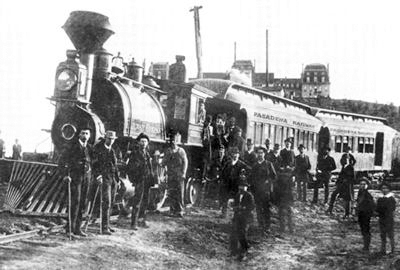
The Los Angeles and San Gabriel Valley Railroad was a railroad founded on September 5, 1883, by James F. Crank with the goal of bringing a rail line to Pasadena, California from downtown Los Angeles, the line opened in 1886. Los Angeles and San Gabriel Valley Railroad was sold and consolidated on May 20, 1887 into the California Central Railway. In 1889 this was consolidated into Southern California Railway Company. On Jan. 17, 1906 Southern California Railway was sold to the Atchison, Topeka and Santa Fe Railway and called the Pasadena Subdivision. The main line closed in 1994. The railroad later reopened as the MTA Gold Line Light Rail service in July 2003.
There are several neighborhoods in the city of Pasadena, California