
The United Nations Convention on the Law of the Sea (UNCLOS), also called the Law of the Sea Convention or the Law of the Sea treaty, is the international agreement that resulted from the third United Nations Conference on the Law of the Sea, which took place between 1973 and 1982. The Law of the Sea Convention defines the rights and responsibilities of nations with respect to their use of the world's oceans, establishing guidelines for businesses, the environment, and the management of marine natural resources. The Convention, concluded in 1982, replaced four 1958 treaties. UNCLOS came into force in 1994, a year after Guyana became the 60th nation to ratify the treaty. As of June 2016, 167 countries and the European Union have joined in the Convention. It is uncertain as to what extent the Convention codifies customary international law.

The terms international waters or trans-boundary waters apply where any of the following types of bodies of water transcend international boundaries: oceans, large marine ecosystems, enclosed or semi-enclosed regional seas and estuaries, rivers, lakes, groundwater systems (aquifers), and wetlands.

Freedom of the seas is a principle in the international law and sea. It stresses freedom to navigate the oceans. It also disapproves of war fought in water. The freedom is to be breached only in a necessary international agreement.
Law of the Sea is a body of international law that concerns the principles and rules by which public entities, especially states, interact in maritime matters, including navigational rights, sea mineral rights, and coastal waters jurisdiction. It is the public law counterpart to admiralty law, which concerns private maritime intercourse. The United Nations Convention on the Law of the Sea (UNCLOS), concluded in 1982 and coming into force in 1994, is generally accepted as a codification of customary international law of the sea.

The intertidal zone, also known as the foreshore and seashore and sometimes referred to as the littoral zone, is the area that is above water at low tide and underwater at high tide. This area can include many different types of habitats, with many types of animals, such as starfish, sea urchins, and numerous species of coral.
Canadian Internal Waters is a Canadian term for the waters "on the landward side of the baselines of the territorial sea of Canada."
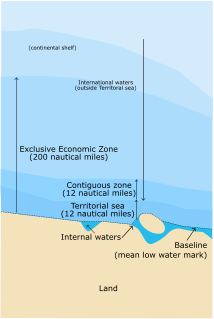
According to the United Nations Convention on the Law of the Sea, a nation's internal waters include waters on the side of the baseline of a nation's territorial waters that is facing toward the land, except in archipelagic states. It includes waterways such as rivers and canals, and sometimes the water within small bays.
Hot pursuit refers to the urgent and direct pursuit of a criminal suspect by law enforcement officers, or by belligerents under international rules of engagement for military forces. Such a situation grants the officers in command powers they otherwise would not have.

Socotra Rock is a submerged rock 4.6 metres (15 ft) below sea level located in the Yellow Sea. International maritime law stipulates that a submerged rock outside of a nation's territorial sea can not be claimed as territory by any nation. However, the rock is the subject of a maritime dispute between South Korea and China, which consider it to lie within their respective exclusive economic zones.
A baseline, as defined by the United Nations Convention on the Law of the Sea, is the line along the coast from which the seaward limits of a state's territorial sea and certain other maritime zones of jurisdiction are measured, such as a state's exclusive economic zone. Normally, a sea baseline follows the low-water line of a coastal state. When the coast is deeply indented, has fringing islands or is highly unstable, straight baselines may be used.
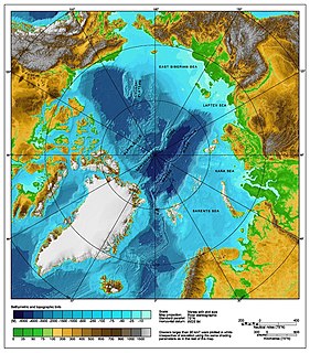
The Arctic consists of land, internal waters, territorial seas, exclusive economic zones (EEZs) and high seas. All land, internal waters, territorial seas and EEZs in the Arctic are under the jurisdiction of one of the eight Arctic coastal states: Canada, Norway, Russia, Denmark, Iceland, Sweden, Finland and the United States. International law regulates this area as with other portions of the Earth.

Portugal has the 5th largest exclusive economic zone (EEZ) within Europe, 4th largest of the EU and the 20th largest EEZ in the world, at 1,727,408 km2.

Subi Reef, also known as Zhubi Reef is a reef in the Spratly Islands of the South China Sea located 26 km (16 mi) southwest of Philippine-occupied Thitu Island. It is occupied by China, and claimed by Taiwan, Vietnam, and the Philippines. It currently falls under the de facto jurisdiction of Nansha islands, Sansha city, Hainan province, China.

Philippines v. China, also known as the South China Sea Arbitration, was an arbitration case brought by the Republic of the Philippines against the People's Republic of China under Annex VII to the United Nations Convention on the Law of the Sea (UNCLOS) concerning certain issues in the South China Sea including the legality of China's Nine-dash line.

The exclusive economic zone of Somalia covers 830,389 km2 in the Indian Ocean. It extends to a distance of 200 nautical miles from the baselines, from which the breadth of the nation's territorial waters is measured. In accordance with Law No. 37 passed in 1972, Somalia's EEZ falls under its territorial sovereignty.
Qit'at Jaradah is a cay in the Persian Gulf to the east of Bahrain Island, located 32 km (20 mi) east of Manama, the capital of Bahrain. Historically, the feature is above water only during spring low tide; it sits approximately midway between Bahrain and Qatar, within the 12-mile (19 km) territorial waters of both countries. It was one of several maritime features contributing to a long running dispute between Bahrain and Qatar.


