Lowe Stand

Last updated
Hoyland Lowe Stand Hoyland Lowe Stand 2014.jpg
Hoyland Lowe Stand

Lowe Stand is an 18th-century folly built for Thomas Watson-Wentworth, 1st Marquess of Rockingham, and likely originally intended as a hunting lodge. [1] It is situated in the South Yorkshire town of Hoyland, 5 miles (8 km) southeast of Barnsley. Today the stand is a Grade II listed building [2] but is in a fairly advanced state of decay. [1] In 2008 the deeds were handed over from the council to voluntary group, the Friends of Hoyland Lowe Stand (now the Lowe Stand Trust). [3] The council has given permission to restore it according to the plan produced. [4]

Folly architectural structure characterized by a certain excess in terms of eccentricity, cost, or conspicuous inutility; often found in gardens or parks

In architecture, a folly is a building constructed primarily for decoration, but suggesting through its appearance some other purpose, or of such extravagant appearance that it transcends the range of garden ornaments usually associated with the class of buildings to which it belongs.

Thomas Watson-Wentworth, 1st Marquess of Rockingham, KB, PC (I) of Wentworth Woodhouse, Yorkshire was a British Whig politician who sat in the House of Commons from 1715 until 1728 when he was raised to the Peerage as Baron Malton.

South Yorkshire County of England

South Yorkshire is a metropolitan county in England. It is the southernmost county in the Yorkshire and the Humber region and had a population of 1.34 million in 2011. It has an area of 1,552 square kilometres (599 sq mi) and consists of four metropolitan boroughs, Barnsley, Doncaster, Rotherham and Sheffield. South Yorkshire was created on 1 April 1974 as a result of the Local Government Act 1972.Its largest settlement is Sheffield.

Related Research Articles

Humber Forts

The Humber Forts are two large fortifications in the mouth of the Humber Estuary in northern England: Haile Sand Fort and Bull Sand Fort.

Limehouse Town Hall former town hall in Limehouse, London

Limehouse Town Hall is a former town hall building on Commercial Road, in Limehouse, in the London Borough of Tower Hamlets.

Metropolitan Borough of Barnsley Metropolitan Borough in England

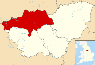
The Metropolitan Borough of Barnsley is a metropolitan borough of South Yorkshire, England; its main town is Barnsley.

High Hoyland village in the United Kingdom

High Hoyland is a village and civil parish in the Metropolitan Borough of Barnsley in South Yorkshire, England, on the border with West Yorkshire. It lies to the west of Kexbrough, and is located at approximately 53°35′10″N1°35′30″W, at an elevation of around 200 metres above sea level. At the 2001 census it had a population of 142, reducing to 128 at the 2011 Census.

Hoyland town near Barnsley in South Yorkshire, England

Hoyland is a town near Barnsley in Northern England. The town developed from the hamlets of Upper Hoyland, Hoyland and Hoyland Common.

St John and St Mary Magdalene Church, Goldthorpe Church

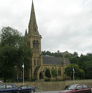
St John the Evangelist and St Mary Magdalene Church is a parish church in the Church of England Diocese of Sheffield in Goldthorpe, near Barnsley, South Yorkshire, England.

Municipal Buildings, Liverpool

Municipal Buildings is a Grade II* listed building on Dale Street, Liverpool, England.

Barnsley West and Penistone (UK Parliament constituency) Parliamentary constituency in the United Kingdom

Barnsley West and Penistone was a parliamentary constituency in South Yorkshire which returned one Member of Parliament (MP) to the House of Commons of the Parliament of the United Kingdom, elected by the first-past-the-post voting system.

Beckfoot Bridge grade II listed construction in the United kingdom

Beckfoot Bridge was historically a significant crossing point over Harden Beck in Bingley, West Yorkshire, England.

Carnaby, East Riding of Yorkshire farm village in the United Kingdom

Carnaby is a small village and civil parish on the A614 road in the East Riding of Yorkshire, England. It is situated approximately 2 miles (3 km) south-west of Bridlington town centre.

Elsecar Heritage Centre

Elsecar Heritage Centre is a living history centre in Elsecar, Barnsley, England.

Wool Exchange, Bradford Grade I listed building in the United Kingdom

The Wool Exchange Building in Bradford, West Yorkshire, England is a grade I-listed building built as a wool-trading centre in the 19th century. The grandeur of its Gothic Revival architecture is symbolic of the wealth and importance that wool brought to Bradford. Today it contains a small shopping centre.

Carlton Towers Grade I listed building in Selby, United Kingdom

Carlton Towers is a Grade I listed Victorian gothic country house in Carlton, North Yorkshire, England.

1st White Cloth Hall

The 1st White Cloth Hall is a Grade II* listed building on Kirkgate, in the city centre of Leeds in West Yorkshire, England.

Bettisons Folly

Bettison's Folly is a tower in Hornsea, East Riding of Yorkshire, England. Also referred to as Bettisons Tower and the Forgotten Folly, it was built some time between 1829 and 1853 by William Bettison.

Skidby Windmill

Skidby Windmill is a Grade II* listed windmill at Skidby near Beverley, in the East Riding of Yorkshire, England.

St Thomass Church, Huddersfield church in United Kingdom

St Thomas's Church is a Church of England church in the Diocese of Leeds. It is situated in Huddersfield, West Yorkshire, England and is a Grade II* listed building. The church was designed by Sir George Gilbert Scott and built between 1857 and 1859. It was consecrated in 1859 and celebrated its 150th anniversary in 2009.

Leeds Club Grade II* listed Victorian building in Leeds.

The Leeds Club is a Grade II* listed Victorian building in Leeds, West Yorkshire, England. It is situated on Albion Place in the city centre.

There are over 9,000 Grade I listed buildings in England. This page is a list of these buildings in the district of Craven in North Yorkshire.

Lytham Windmill Fylde, Lancashire, FY8

Lytham Windmill is situated on Lytham Green in the coastal town of Lytham St Annes, Lancashire, England. It is of the type known as a tower mill and was designed for grinding wheat and oats to make flour or bran. Since commercial milling on the site ceased in 1921 the mill has belonged to the town and is operated by Fylde Borough Council, who open it to the public during the summer. The mill also contains a museum run by the Lytham Heritage Trust which explains the history and practice of flour milling.

References

Historic England Executive non-departmental public body of the British Government, tasked with protecting the historical environment of England

Historic England is an executive non-departmental public body of the British Government sponsored by the Department for Culture, Media and Sport (DCMS). It is tasked with protecting the historical environment of England by preserving and listing historic buildings, ancient monuments and advising central and local government.

Images of England is an online photographic record of all the listed buildings in England at the date of February 2002. The archive gives access to over 323,000 colour images, each of which is matched with the item’s listed designation architectural description.

Coordinates: 53°30′15″N1°27′14″W / 53.5042°N 1.4539°W / 53.5042; -1.4539

Geographic coordinate system Coordinate system

A geographic coordinate system is a coordinate system that enables every location on Earth to be specified by a set of numbers, letters or symbols. The coordinates are often chosen such that one of the numbers represents a vertical position and two or three of the numbers represent a horizontal position; alternatively, a geographic position may be expressed in a combined three-dimensional Cartesian vector. A common choice of coordinates is latitude, longitude and elevation. To specify a location on a plane requires a map projection.