Lower Sava Valley

Last updated
Landscape near Radece LokaPriZidanemMostu1.jpg
Landscape near Radeče

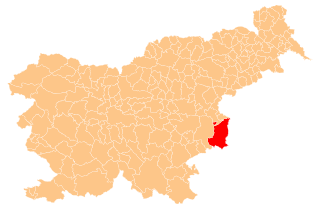
The Lower Sava Valley (Slovene : Posavje, also Spodnje Posavje and Posavska regija [1] ) is a region in southeastern Slovenia on the border with Croatia. It has three major urban centers: Brežice, Krško, and Sevnica. Its borders are almost identical with those of the Lower Sava statistical region.

Slovene language language spoken in Slovenia

Slovene or Slovenian belongs to the group of South Slavic languages. It is spoken by approximately 2.5 million speakers worldwide, the majority of whom live in Slovenia. It is the first language of about 2.1 million Slovenian people and is one of the 24 official and working languages of the European Union.

In geography, regions are areas that are broadly divided by physical characteristics, human impact characteristics, and the interaction of humanity and the environment. Geographic regions and sub-regions are mostly described by their imprecisely defined, and sometimes transitory boundaries, except in human geography, where jurisdiction areas such as national borders are defined in law.

Slovenia republic in Central Europe

Slovenia, officially the Republic of Slovenia, is a sovereign state located in southern Central Europe at a crossroads of important European cultural and trade routes. It is bordered by Italy to the west, Austria to the north, Hungary to the northeast, Croatia to the southeast, and the Adriatic Sea to the southwest. It covers 20,273 square kilometers (7,827 sq mi) and has a population of 2.07 million. One of the successor states of the former Yugoslavia, Slovenia is a parliamentary republic and a member of the United Nations, of the European Union, and of NATO. The capital and largest city is Ljubljana.

It extends along the lower part of the Sava River, on the border with Croatia. In terms of its acreage, it is the second smallest region in Slovenia because it has only 885 km² and covers 4.4 percent of Slovenia’s territory. The neighboring regions are the Savinja region to the north, the Central Sava Valley (Slovene : Zasavje) to the west, and Lower Carniola to the south.

Sava river in Southeast Europe

The Sava is a river in Central and Southeastern Europe, a right tributary of the Danube. It flows through Slovenia, Croatia, along the northern border of Bosnia and Herzegovina, and through Serbia, discharging into the Danube in Belgrade. Its central part is a natural border of Bosnia-Herzegovina and Croatia. The Sava forms the northern border of the Balkan Peninsula, and the southern edge of the Pannonian Plain.

Savinja river in Slovenia

The Savinja is a river in northeast Slovenia which flows mostly in the Upper and Lower Savinja Valley and through the cities of Celje and Laško. The Savinja is the main river of the Savinja Alps. It flows into the Sava River at the town of Zidani Most. It has often flooded, such as in the 1960s, 1990, and 1995. The Savinja has a length of 101.75 kilometres (63.22 mi) and a catchment area of 1,847.7 km2 (713.4 sq mi).

Central Sava Valley

The Central Sava Valley is a valley in the Sava Hills and a geographic region along the Sava in central Slovenia, now constituting the Central Sava Statistical Region. The region consists of three municipalities: Zagorje ob Savi, Trbovlje, and Hrastnik. Several coal mines operated in the Central Sava Valley, although all except the Trbovlje–Hrastnik Mine are now defunct. It is surrounded by the Sava Hills, with Kum on the right side of the Sava and Black Peak on Čemšenik Pasture at the left side of the Sava, as its highest peaks.

According to the 2003 census, 70,262 people lived in the region, which constitutes 3.5 percent of Slovenia’s population. The region represents approximately 4.5% of Slovenian territory and covers 885 km². It is not densely populated; there are 79 people per km². The inhabitants live in 409 settlements. The following municipalities are part of the Lower Sava Valley: Krško, Brežice, Sevnica, Kostanjevica na Krki, Radeče, and Bistrica ob Sotli.

Kostanjevica na Krki Place in Lower Carniola, Slovenia

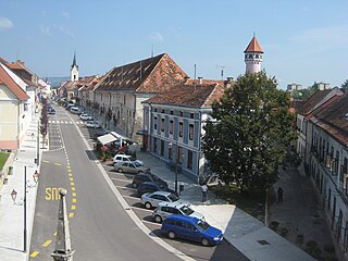
Kostanjevica na Krki, is a small town in the historic Lower Carniola region of southern Slovenia. It is the seat of the Municipality of Kostanjevica na Krki. Today it is part of the Lower Sava Statistical Region. It is located in the northern foothills of the Gorjanci Hills near the border with Croatia. The center of the settlement is on an island in the Krka River, and it is also promoted as the "Venice of Lower Carniola" in Slovenian.

Radeče Town in Slovenia

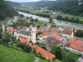
Radeče is a small town in the Lower Sava Valley in eastern Slovenia. It is located in the Sava Hills on the right bank of the Sava River at the confluence with Sopota Creek. It is the centre of the Municipality of Radeče and part of the traditional province of Lower Carniola. The town and the municipality are now included in the Lower Sava Statistical Region; until January 2014 they were part of the Savinja Statistical Region.

Bistrica ob Sotli Place in Styria, Slovenia

Bistrica ob Sotli is a settlement in eastern Slovenia. It is the seat of the Municipality of Bistrica ob Sotli. The settlement lies on a river terrace above the right bank of the Sotla River. The area traditionally belonged to the region of Styria. It is now included in the Lower Sava Statistical Region; until January 2014 it was part of the Savinja Statistical Region. The settlement includes the hamlets of Čehovec, Koče, and Marof.

The Lower Sava Valley is a popular tourist destination due to its cultural, natural, and historical riches. Local culinary specialties, high-quality wines, and towns with rich heritage offer many opportunities for both fun and relaxation. There are many walking trails, riding trails, golf courses, and spas.

Related Research Articles

Krško Place in Lower Carniola, Slovenia

Krško is a town in eastern Slovenia. It is the seat of the Municipality of Krško. The town lies on the Sava River. The area is traditionally divided between Styria and Lower Carniola. The entire municipality is now included in the Lower Sava Statistical Region.

Styria (Slovenia) Traditional region in Slovenia

Styria, also Slovenian Styria or Lower Styria, is a traditional region in northeastern Slovenia, comprising the southern third of the former Duchy of Styria. The population of Styria in its historical boundaries amounts to around 705,000 inhabitants, or 34.5% of the population of Slovenia. The largest city is Maribor.

Sevnica Place in Styria, Slovenia

Sevnica is a town on the left bank of the Sava River in central Slovenia. It is the seat of the Municipality of Sevnica. It is one of the three major settlements in the Lower Sava Valley. The old town of Sevnica lies beneath Sevnica Castle, which is perched on top of Castle Hill, while the new part of town stretches along the plain among the hills up the Sava Valley, forming another town core at the confluence of the Sevnična and Sava rivers.

Brežice Place in Styria, Slovenia

Brežice is a town in eastern Slovenia in the Lower Sava Valley, near the Croatian border. It is the seat of the Municipality of Brežice. The area was traditionally divided between Lower Styria and Lower Carniola. The whole municipality is now included in the Lower Sava Statistical Region.

Sutla river

The Sutla (Croatian) or Sotla (Slovene) is a river flowing through Slovenia and Croatia, mostly forming their border. It is a tributary to the Sava, itself a tributary to the Danube. It is 89 kilometres (55 mi) long and has a watershed area of 584 square kilometres (225 sq mi).

Lower Carniola Traditional region in Slovenia

Lower Carniola is a traditional region in Slovenia, the southeastern part of the historical Carniola region.

Krka (Sava) river in southern Slovenia

The Krka is a river in southeastern Slovenia, a right tributary of the Sava. With a length of 94.6 km (58.8 mi), it is the second-longest river flowing in its entirety in Slovenia, following the Savinja.

Brežice Castle

Brežice Castle is a 16th-century castle in the town of Brežice, in southeastern Slovenia, at the street address Cesta prvih borcev 1.

Jesenice, Brežice Place in Lower Carniola, Slovenia

Jesenice is a settlement on the right bank of the Sava River in the Municipality of Brežice in eastern Slovenia, right on the border with Croatia. The area was traditionally part of Lower Carniola. During the Second World War it was one of five Slovene settlements annexed by the Independent State of Croatia. It is now included in the Lower Sava Statistical Region.

Lower Sava Statistical Region Statistical region

The Lower Sava Statistical Region is a statistical region in Slovenia. It has good traffic accessibility and is located in the Sava and Krka Valleys, with hilly areas with vineyards and an abundance of water. It is the second-smallest statistical region in Slovenia. The only nuclear power plant in the country and Čatež spa are located in the region. The region annually spends EUR 22 million on environmental protection. In 2013, the employment rate in the region was 57.5%. The region was characterized by the largest difference between the employment rate for men and for women. In 2013 this region also stood out in number of convicted persons per 1,000 population (8.3).

Bračna Vas Place in Styria, Slovenia

Bračna Vas is a small settlement on the right bank of the Sotla River in the Municipality of Brežice in eastern Slovenia. It lies northeast of Bizeljsko, right next to the border with Croatia. The area was traditionally part of Styria. It is now included in the Lower Sava Statistical Region.

Slovenska Vas, Brežice Place in Lower Carniola, Slovenia

Slovenska Vas is a settlement in the Municipality of Brežice in eastern Slovenia, next to the border with Croatia. The area was traditionally part of Lower Carniola. During the Second World War, when it was known as Bregansko selo, it was one of five Slovene settlements annexed by the Independent State of Croatia. It is now included with the rest of the municipality in the Lower Sava Statistical Region.

Sobenja Vas Place in Lower Carniola, Slovenia

Sobenja Vas is a small village in the eastern foothills of the Gorjanci Hills in the Municipality of Brežice in eastern Slovenia, close to the border with Croatia. The area was traditionally part of Lower Carniola. It is now included with the rest of the municipality in the Lower Sava Statistical Region.

Stari Grad, Krško Place in Styria, Slovenia

Stari Grad is a settlement east of the town of Krško in eastern Slovenia. The area was traditionally part of Styria. It is now included with the rest of the municipality in the Lower Sava Statistical Region.

Hudo Brezje Place in Lower Carniola, Slovenia

Hudo Brezje is a settlement in the hills above the right bank of the Sava River in the western Krško Hills in east-central Slovenia. It belongs to the Municipality of Sevnica. The area is part of the historical region of Lower Carniola and is now included in the Lower Sava Statistical Region.

The Lower Sava Valley dialect is a Slovene dialect in the Styrian dialect group, bordering on the Lower Carniolan dialect group. It is spoken in the Sava Valley from Litija to Brežice and along the lower course of the Savinja River. It is divided into three subdialects: the Zagorje-Trbovlje subdialect, Laško subdialect, and Sevnica-Krško subdialect.

The Sevnica-Krško subdialect is a Slovene subdialect in the Styrian dialect group. It is a subdialect of the Lower Sava Valley dialect, extending along both banks of the Sava River from Zidani Most to just before Brežice, and then continuing on the right bank to the Croatian border. The main settlements in the dialect area are Radeče, Loka pri Zidanem Mostu, Boštanj, Sevnica, Zabukovje nad Sevnico, Brestanica, Senovo, Krško, Drnovo, Cerklje ob Krki, Čatež ob Savi, and Velika Dolina.

Municipality of Krško Municipality in Slovenia

The Municipality of Krško is a municipality in eastern Slovenia. Its seat is the town of Krško. The area is traditionally divided between Lower Styria and Lower Carniola. The entire municipality is now included in the Lower Sava statistical region.

Brezje, Sevnica Place in Lower Carniola, Slovenia

Brezje is a small village in the Municipality of Sevnica in southeastern Slovenia. It lies on a small rise east of Krmelj and the village of Hinjce and west of the Mirna River. Until 2006, the area was part of the settlement of Goveji Dol. The village is part of the traditional region of Lower Carniola and is included in the Lower Sava Statistical Region. One of the two roads from Krmelj to the main road linking Mokronog and Sevnica runs through the settlement, in the valley south of the village core. A cattle trough stands on its right side at the crossroad leading from it into the village. It was built in the 1940s.

Municipality of Brežice Municipality in Slovenia

The Municipality of Brežice is a municipality in eastern Slovenia in the Lower Sava Valley, near the Croatian border. The seat of the municipality is the town of Brežice. The area was traditionally divided between Lower Styria and Lower Carniola. The entire municipality is now included in the Lower Sava Statistical Region.

References

  1. Ferenc, Tone. 1995. "Posavje". Enciklopedija Slovenije vol 9. Ljubljana: Mladinska knjiga, pp. 155–156.

Coordinates: 45°57′0″N15°29′0″E / 45.95000°N 15.48333°E / 45.95000; 15.48333

Geographic coordinate system Coordinate system

A geographic coordinate system is a coordinate system that enables every location on Earth to be specified by a set of numbers, letters or symbols. The coordinates are often chosen such that one of the numbers represents a vertical position and two or three of the numbers represent a horizontal position; alternatively, a geographic position may be expressed in a combined three-dimensional Cartesian vector. A common choice of coordinates is latitude, longitude and elevation. To specify a location on a plane requires a map projection.